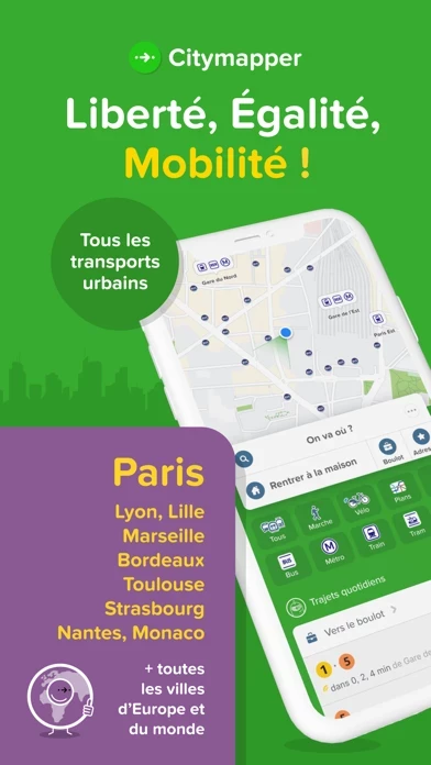
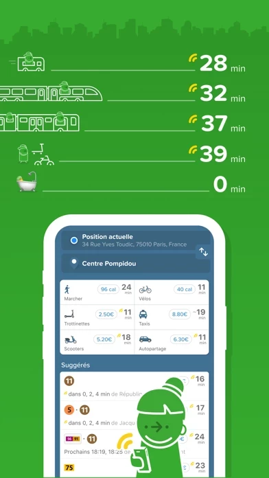
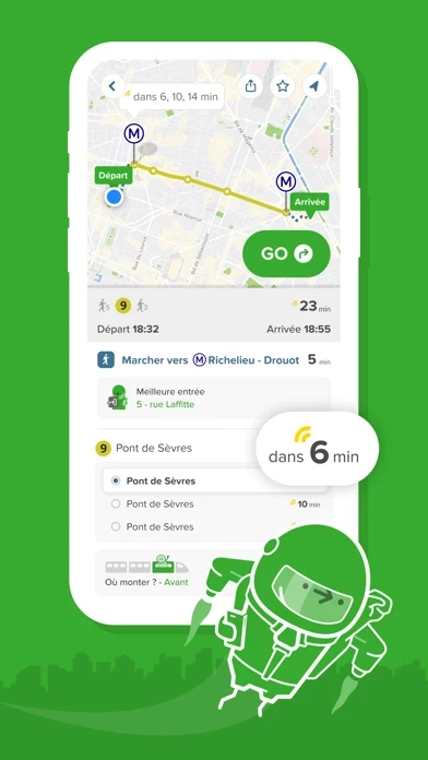
Citymapper: All Live Transit

Citymapper: All Live Transit Software


Company Name:

About: Citymapper is a transport app for cities.
Headquarters: London, England, United Kingdom.

 
  2023-10-28

Citymap Overview


What is Citymap? The Citymapper app is a comprehensive travel app that allows users to compare travel options in real-time across all transport modes globally. It provides turn-by-turn directions for public transportation, walking, cycling, and scooter trips. The app also allows users to compare cab fares, hail a ride, hop on a shared bike, or find the nearest e-scooter all from within the app. It covers several cities worldwide and uses open data from transit agencies in the cities it covers.


Features


- Simple trip planning combining all transport modes: bus, subway, train, ferry, cabs, ride share, car share, bike share, e-scooters, and walking.

- Turn-by-turn navigation for all your transit, walking, personal cycling, bike shares, and scooter trips.

- Compare cab fares, hail a ride, hop on a shared bike, or find the nearest e-scooter all from within the app.

- Live wait times and ETA so you'll never miss a bus, train, or ferry again.

- Save Home, Work, and your go-to stops or stations for lightning-fast trip planning.

- Share your live trip with friends to know when you'll arrive.

- Access offline the official NYC subway map, Manhattan bus map, Brooklyn bus map, Queens bus map, DC metro map, Muni Metro map, and more.

- Covers several cities worldwide and uses open data from transit agencies in the cities it covers.


Official Screenshots


Product Details and Description of


Instantly compare your travel options in real-time across all transport modes globally! Easily navigate your city with turn-by-turn directions for all your public transportation, walking, cycling and scooter trips. THOUSANDS OF 5 STAR REVIEWS * "This is my favorite transit app. Full-featured and a breeze to use. I really appreciate the Uber integration." * "Only way to get around NYC and Chicago. Easy and accurate. Download this one NOW" * "I love it. It’s the best thing since zippers, peanut and jelly and 1 TB thumb drives" * "Support for the SF Bay Area is particularly impressive because it aggregates all transit systems imaginable (BART, Caltrain, MUNI, VTA, etc.) into one seamless app" FIND THE BEST ROUTE ► Simple trip planning combining all transport modes: bus, subway, train, ferry, cabs, ride share, car share, bike share, e-scooters and walking. Discover routes you never knew existed HIT THE GO BUTTON FOR STEP-BY-STEP DIRECTIONS ► Turn-by-turn navigation for all your transit, walking, personal cycling, bike shares and scooter trips. Choose between 3 different map views, see the charge levels of e-scooters and e-bikes around you, we even help you avoid no-parking zones. We take care of the logistical thinking so you are free to enjoy the ride EXPERIENCE ONE-STOP-SHOP MOBILITY ► Compare cab fares, hail a ride, hop on a shared bike or find the nearest e-scooter all from within the app. Our partners include: Uber, Lyft, JUMP, Lime, Bird, Spin, Skip, Scoot, Citi Bike, JerseryBike, Bluebikes, Indego, CaBi, Divvy, Metro Bike, Breeze, Bay Wheels, Healthy Ride, Relay, BCycle, SA Bike Share, GREENbike, Grid, RTC Bike, BIKETOWN, Biki BEAT THE RUSH HOUR CROWD ► Live wait times and ETA so you'll never miss a bus, train or ferry again. Follow your bus / train as it's approaching on a real-time map, see the best train car to board, get alerted when it's time to get off, and get in and out from the best exit at any subway / train station PERSONALIZE YOUR CITY ► Save Home, Work and your go-to stops or stations for lightning fast trip planning. Subscribe to your favorite subway, train, bus or ferry line for automatic disruption, delay, and status alerts GET SOCIAL ► Share your live trip: let friends follow your live trip to know when you'll arrive. Share any location or address: one tap for others to get directions TRAVEL OFFLINE ► Access offline the official NYC subway map, Manhattan bus map, Brooklyn bus map, Queens bus map, DC metro map, Muni Metro map, and more CITY COVERAGE ► New York City | Chicago | Los Angeles | San Francisco | Washington DC | Boston | Philadelphia | Seattle | Miami | Atlanta | Portland | Denver | Baltimore | San Diego | Minneapolis | Houston | Phoenix | Dallas | Las Vegas | Pittsburgh | Honolulu | Salt Lake City | San Antonio | St. Louis | Cleveland | Austin + Many more worldwide! See the full list and vote for the next one in the app or at https://this app.com/cities TRANSIT AGENCIES ► We use open data from transit agencies in the cities we cover, including: MTA | CTA | LA Metro | MBTA | WMATA | SEPTA | NJ Transit | Muni | BART | King Bus | MARTA | LIRR | RTD | TriMet | Metro-North Railroad | PATH | Houston METRO | San Diego MTS | Miami-Dade Transit | Metro Transit | METRA | RTC Bus | TheBus | Port Authority | DART | AC Transit | Sound Transit | UTA | OCTA | VIA | PTD | Metro Transit | RTA | Capital Metro | Broward County Transit Division | NY Waterway Ferries | Washington State Ferries | LBT | Nassau Inter County Express (NICE)| Valley Metro | Metrolink | Santa Monica Big Blue Bus (BBB) KEEP IN TOUCH ► If you have questions or feedback or something we may have missed in your city email us at support@this app.com Like us on Facebook: http://facebook.com/thecitymapper Follow us on Twitter: http://twitter.com/this app Visit our website: http://this app.com


Top Reviews

By Rosie From Boston

LOVE this app

I recently went to NYC for a long weekend and though I know my way around the city pretty well I explored this visit to places I haven’t been, enter the this app app. You put in where you want to and it shows you how to get there and a multitude of ways. Whether it be walking taking the train or taking the bus or taking a cab or taking an Uber or Lyft. It gives you the time of each method of transportation how long it will take you to get there and it even gives you an estimated cab and Uber/Lyft fares. If you opt to take the train like I did it tells what car to get on to be closest to an exit and it even gives you walking directions when exiting the train to reach your final destination. This app is AWESOME! I highly recommend and will use it for years to come. Thank You this app.

By DarfNader

The Only Transit App You’ll Need in SF

I’ve lived in San Francisco since before there was even NextBus (dark, dark times) and since it came to be, I must have tried a dozen apps for years before I discovered this app. The key is that it calculates the ideal route for you taking into account time to walk to stops, when you need to be somewhere, or whether you want to get there fast or walk the least. It also has every transit system, including ferries and county bus lines like Sam Trans and Golden Gate Transit. Finally, the Apple watch app works very well by alerting you when the bus is coming or when your stop is next. I can’t find a single thing about it I don’t like except that the watch app sometimes needs to be manually started to connect, but that’s really it.

By Juper2356678990

This app made me love city travel again

Recently I visited NYC for 4 days. I have been there three times and each time I was a stressful ball of mess that would be switching back and forth between three different apps and still managing to get lost. NOT ANYMORE !! this app is the best app on the market for nagavating a big city. It took a few trail and errors to get the hang of it but once I got the gist of the app it was super easy . I love the fact that it gives you multiple options for getting to your destination and you just pick the one that works best for you. My preferences was buses with no transfers . So I found it and picked . I didn’t get lost not one time with this app and it actually made traveling the city seem like a breeze .


Most Popular Apps in Navigation