Nautical Maps Overview
What is Nautical Maps?
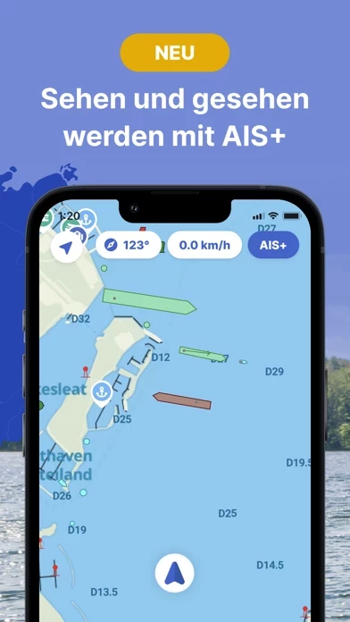
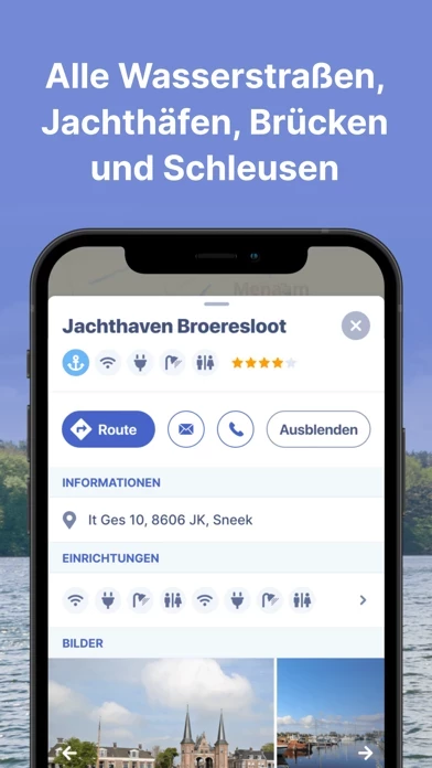
The Nautical Maps app is a comprehensive app for safe and prepared boating navigation. It offers complete nautical maps of the United Kingdom, Netherlands, Germany, and Belgium, access to all information from the paper ANWB Water Almanac 2, current information about marinas, bridges, and locks, and a route planner to plan the optimal route between your starting point and destination. The app also includes AIS+ to share your position in real-time and see where surrounding ships are located, offline use, and regular updates with free access to all new features.
Features
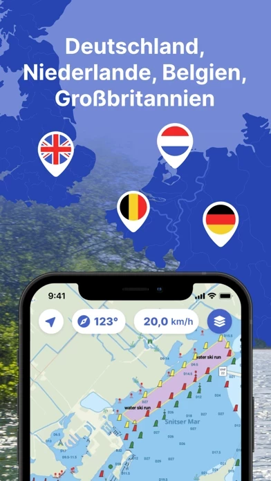
- Complete nautical maps of the United Kingdom, Netherlands, Germany, and Belgium
- Access to all information from the paper ANWB Water Almanac 2
- Current information about marinas, bridges, and locks including opening times
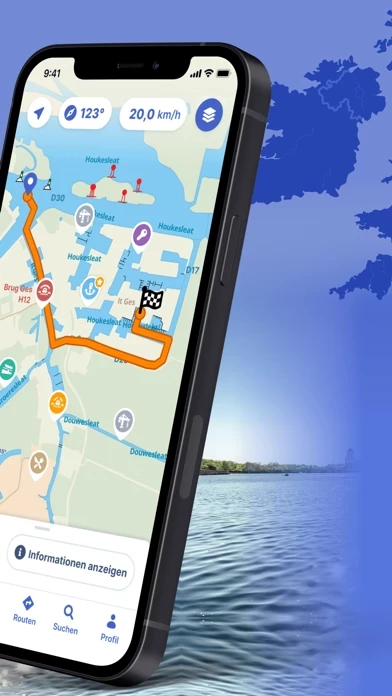
- Route planner to plan the optimal route between your starting point and destination
- AIS+ to share your position in real-time and see where surrounding ships are located (currently only available for the Netherlands)
- Show or hide information on the nautical maps to see exactly what you need
- Stay up-to-date with the current navigation reports and obstructions from the Rijkswaterstaat
- More than 200,000 nautical objects (bridges, locks, markings, mooring places, and more)
- Locations of more than 4,000 marinas and all details of existing facilities
- Offline use by downloading the corresponding charts
- Regular updates and free access to all new features
- Each user account can be used on up to 3 devices at no extra cost
- Free Windows version included with the subscription
- Reliable service with support available 7 days a week
- Monthly, seasonal, and annual subscription options available
- Automatic subscription renewal
- Payment methods include iTunes account, PayPal, or credit card
- Account creation to activate subscription on up to 3 devices
- Note: The app is only intended as an aid when navigating on the water. Stay alert to your surroundings while boating.
Official Screenshots
Product Details and Description of
The most comprehensive app for safe and prepared boating navigation. With ANWB Water Almanac 2, route planner, water maps, AIS+, marinas, bridges, locks, offline use and more. Try now and plan your next trip! With the Nautical Maps app you have everything you need at hand: • 4 countries, 1 price: Complete nautical maps of the United Kingdom, Netherlands, Germany and Belgium • Access all information from the paper ANWB Water Almanac 2 with just a few taps in the app • All current information about marinas, bridges and locks including opening times • Plan the optimal route between your starting point and destination, including the objects you encounter (beta 2.0) • New! AIS+: Share your position in real time and see at a glance where surrounding ships are located (currently only available for the Netherlands) • Show or hide information on the nautical maps to see exactly what you need • Stay up-to-date with the current navigation reports and obstructions from the Rijkswaterstaat • More than 200,000 nautical objects (bridges, locks, markings, mooring places and more) • Locations of more than 4,000 marinas and all details of existing facilities • Radio silence on the water? No problem! Download the corresponding charts for offline use • Regular updates and free access to all new features • Each user account can be used on up to 3 devices at no extra cost • Free Windows version included with the subscription • Reliable service: We are at your service 7 days a week ([email protected]) How the subscription works: Nautical Maps is free for the first 7 days. After that, the app only works with a valid subscription. You can purchase the following subscriptions: • Monthly subscription (€ 12,99) • Seasonal subscription (3 months for just € 29,99) • Annual subscription (€ 43,99) The subscription ends automatically. Please note: If you purchase a subscription during the free 7-day trial period, we will add your new credit to your remaining balance. Your purchased subscription is not automatically renewed. Payment methods for subscription: • The subscription will be charged to your iTunes account • At Apple you can use different payment methods for a subscription, such as PayPal or credit card Even more boating pleasure with a Nautical Maps account You can create an account in the app to activate your subscription on a total of 3 devices. Note: • The file size of the offline map material is very large and you are advised to download it on a stable Wi-Fi connection • Prolonged use of GPS in the background can considerably shorten the battery life of your device Do you have questions about the app? Please contact our helpdesk ([email protected]) or read more on our website (www.waterkaarten.app/en). Please note that this app is only intended as an aid when navigating on the water. Stay alert to your surroundings while boating.
Top Reviews
By Juan Trippe
Very good
This is a very good app for cruising the Holland canals. I wish it was in English, but useful nonetheless.
By DevilDog[USMC]
Useless
Can’t get it to do anything and it’s only a trial.