savvy navvy: Boat Navigation Software
Company Name: savvy navvy
About: Marine navigation in seconds, just two clicks and you're done!
Headquarters: London, England, United Kingdom.
savvy navvy Overview
What is savvy navvy?
The Savvy Navvy app is a comprehensive navigation tool for boaters, sailors, paddleboarders, jet skiers, kayakers, and fishermen. It offers free features such as USA nautical charts, weather forecasts, departure scheduling, GPS tracking, automatic weather routing, and marina information. The app also has premium features such as unlimited worldwide charts, multi-day weather forecasts, offline charts and weather, satellite chart overlay, and anchor alarm. The app is available on multiple devices and has a dedicated customer service team to assist users.
Features
- Access to all USA nautical savvy charts
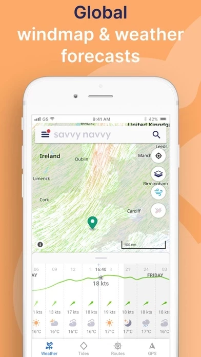
- Weather forecast
- Departure scheduling
- Record GPS tracks
- Automatic weather routing, including Course to Steer (CTA)
- Marina information
- Unlimited worldwide savvy charts
- Multi-day weather forecast
- Unlimited GPS tracks
- Multi-day departure scheduler
- Offline charts and weather
- Satellite chart overlay
- Anchor alarm
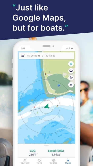
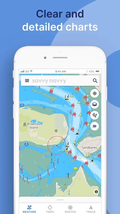
- Chart navigation
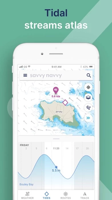
- Tidal heights and streams graph
- Active tracking
- Automatic routing
- Route export
- Marina and anchorage information
- Dedicated customer service.
Official Screenshots

savvy navvy Pricing Plans
| Duration | Amount (USD) |
|---|---|
| Billed Once | $33.32 |
**Pricing data is based on average subscription prices reported by Justuseapp.com users..
Product Details and Description of
Everything you need to get out on the water, if you are a boater, sailor, paddleboarder, Jet skier, Kayaker or just going fishing, we’ve got you covered. Free Features - • All USA nautical savvy charts TM • Weather Forecast • Departure scheduling • Record GPS Tracks • Automatic weather routing, including Course to Steer(CTA) • Marina information at the touch of a button. • And much more One app, multiple devices. Premium Features • Unlimited Worldwide savvy charts TM • Multi-day weather forecast • Unlimited GPS Tracks • Multi-day Departure Scheduler • Offline charts and weather • Satellite chart overlay • Anchor Alarm FEATURES CHART NAVIGATION Get access to all savvy charts, wherever we have coverage. Our sailing maps have been custom-built using quality data from NOAA, UKHO and other hydrographic offices around the world to provide easy and safe sailing navigation. TIDAL HEIGHTS & STREAMS GRAPH View tidal heights and streams on our tide chart. Scroll through the tidal graph to see changes in tidal highs and lows over time. WEATHER FORECASTS Use the weather forecast graph to scroll through days and times to see the effect on weather conditions, wind strength and direction. Use the wind icon to see a visual overlay of wind barbs! ACTIVE TRACKING Use boat tracking to hone in on your boat GPS location, see your course over ground (COG) and view your speed over ground (SOG). savvy navvy is essentially your nautical GPS! AUTOMATIC ROUTING Plot a sailing route in seconds with automatic course to steer. Drop a pin to indicate your start and finish points and savvy navvy will quickly plot a route to sail taking into account wind, chart and tidal data. 1. Drop a pin at your start and finish locations 2. Calculate your route 3. Preview your route and get an Estimated Time of Arrival 4. Export your route for use with your chart plotter ROUTE EXPORT Marine navigation made easy! Plot your route with savvy navvy and then export the GPX file for use with your chart plotter. Boating navigation couldn’t be easier! MARINA & ANCHORAGE INFORMATION Tap our dedicated icons for local marina and anchorage information on our sailing map and find: * VHF channel * Anchorage holding * Overnight weather and wind direction information * Mooring details * Restaurants, bathrooms and toilets * Fuel docks * Water * And much more... DEDICATED CUSTOMER SERVICE Our team is on standby to help you whenever you need us for questions about boating navigation, sailing, the chart plotter or anything else. Our in-app chatbot is managed by real team members with extensive experience in marine navigation who will help you get the most out of your boat navigation app! Read our terms of service here: https://www.savvy-navvy.com/terms-of-service
Top Reviews
By chwnyc
What a great start! Obviously designed by sailors
This is the first sailing app I’ve used that works to answer the most important questions I have as we sail: what is the current doing? Can I point to get there or will I have to tack? Well worth the price of subscription. And more importantly, it doesn’t show extraneous information and map features that clutter up other navigation apps. This adds to convenience, but most importantly SAFETY when a split-second decision is needed and your plotter is the key source of information. Finally it is a beautiful presentation. Our boat is beautiful, and Savvy Navvy fits right in. Other chart plotters look like the product manager’s kid chose the icons and colors. All the features I might want aren’t here yet, but I appreciate how the company is being careful about adding what is essential, vs. throwing the kitchen sink at the product.
By doghousedarr
one improvement
I love this app, but would make one improvement. I would like to see available routes four boats with no motor power. If there is weak wind the app says no route available, but it would be great to see a course, No matter how inefficient. For example if staying at anchor for 18 hours until the wind changes is the only possibility, it would be nice for the app to say that
By Solarken
Better and Better
This app is useful. It has improved from day one. Give feedback and ides and they listen. I’m impressed by the growth from the beginning.