Planimeter 55. Measure on map. Software
Company Name: Kalimex-Consulting s.r.o. @Blocoware & Stanislav Dvoychenko
Planimeter 55 Measure on map Overview
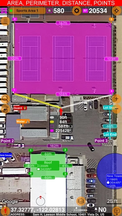
What is Planimeter 55 Measure on map? Planimeter is an app that allows users to measure distance, perimeter, and area on a map. It also allows users to add stand-alone points to better understand what is where on a map. The app is useful for measuring construction sites, roofs, lawns, fences, paving, pools, parking lots, fields, and paths. It also allows users to capture photos stamped with location, direction, altitude, and time, and share and export their projects.
Features
- Precise control of the planned/measured area
- Native Google maps support
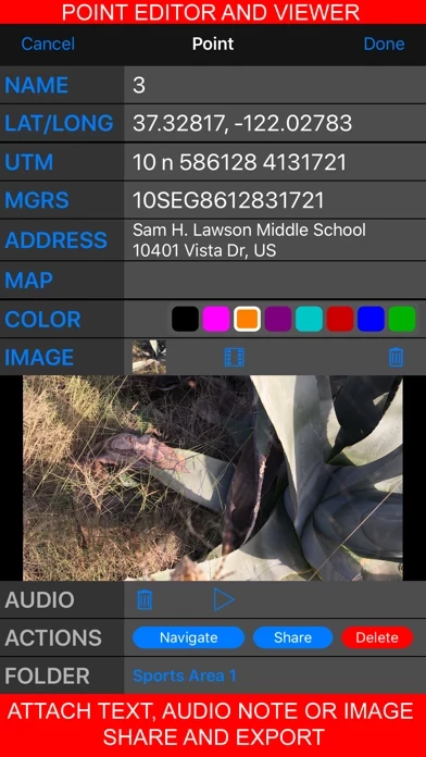
- Every point can have its own color and have text, audio, and image attached
- Ability to move points directly on the main map screen or in the dedicated point editor screen
- Ability to hide/show shapes and point collections
- Flexible units of measurement
- Custom URL, offline, and import maps support
- KMZ export and import option
- Basic version allows users to create an unlimited number of points and temporary measurement shapes
- Pro pack upgrade adds Google and custom URL, offline, imported maps support, ability to save multiple point collections/shapes, import and export for a single point and whole shapes/collections, and saving and sharing a map snapshot
- No subscription or recurring charges involved
- Support email is [email protected] and all emails are answered within hours or up to 9 hours if they come during CET/EU night time.
Official Screenshots


Product Details and Description of
Measure distance, perimeter and area on a map. Add stand alone points to understand better what is where on a map. Capture photos stamped with location, direction, altitude and time. Share and export your projects. Planimeter app will be useful for measuring construction sites, roofs, lawns, fences, paving, pools, parking lots, fields and paths. Or even for just putting stand alone points on a map. Where this planimeter app stands out? - Precise control of the planned/measured area. As you move a map, the app will show you what area/distance is going to be and what would be the size of adjacent lines. Even before you add a new point. - Native Google maps support adds extra zoom-in ability for satellite and hybrid maps. - Every point can have its own color and have text, audio and image attached. - You can move point directly on a main map screen (tap on a point and pick Move option) or in the dedicated point editor screen. Again, before you confirm the move you know perfectly what the resulting area/perimeter/distance will be. - You can hide/show shapes and point collections. This way you can focus only on what is important for the current project. - Flexible units of measurement allow you to configure when display of feet or meters changes to miles and kilometers. Same for area units. - Custom url, offline and import maps. Apple maps and Google maps are built into the app. And then, you can add other maps. The app supports adding custom url maps, downloading offline maps or importing maps (mbtiles, sqlitedb) that you might have crafted on your PC or Mac. - Kmz export and import option allows to transfer shapes and point collections in their entirety, including images and audio notes. This allows you to continue working on your project on different devices. Basic version allows you to create unlimited number of points and temporary measurement shapes (areas or routes), so you can measure with no limits. To add a new shape to measure, you just discard the previous one. Pro pack upgrade adds: - Google and custom url, offline, imported maps support. Google maps adds extra zoom ability for satellite and hybrid maps. - Ability to save multiple point collections/shapes. - Import and export for a single point and whole shapes/collections. - Saving and sharing a map snapshot, the one that shows only the objects that you created on a map - buttons and tools removed. Pro Pack upgrade is a one off upgrade, no subscription or recurring charges are involved. Use MENU (hamburger) button > DOCUMENTATION or SUPPORT AND FEEDBACK options to get help. Just in case, support email is [email protected]. All emails are answered within hours or up to 9 hours if they come during CET/EU night time. Wishing your happy measuring! Planimeter 55 team.
Top Reviews
By Boss123z
Excellent app, very useful!
I purchased this app to help me figure out the perimeter lines of my property. This app worked perfectly! This app also helped me locate the survey stakes at rear of my wooded property. I would recommend this to anyone, it’s a very useful tool for measuring your property.
By leathr
magical application tool
amazed every second of every day engineering the new world