National Park Trail Guide Software
Company Name: Recreational Equipment, Inc
About: Miracle Recreation Equipment Company is a recreational facility company providing outdoor playground
equipment.
Headquarters: , , .
National Park Trail Guide Overview
• Plan the perfect trip for you, using our hike difficulty ratings, elevation profiles, star ratings, and informed insights on seasons, camping and lodging, guided tours, food and drink, and more.
• Search for hikes using the map or a park's “best of” list curated through star rankings from the community.
• Other cool features: Create a to-do list, track your hikes, or send your exact location to help in case of emergency.
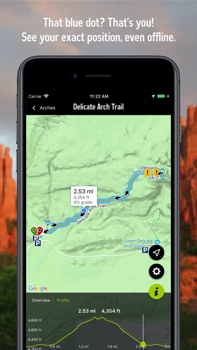
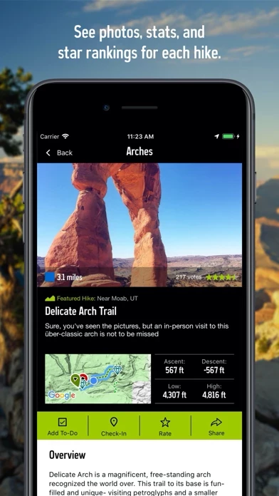
Official Screenshots


Product Details and Description of
National Park Trail Guide is your comprehensive guide to hiking and site seeing in our National Parks. • Currently packing complete trail data and hike descriptions for many of your favorite National Parks, including life-list destinations like Yellowstone, Yosemite, Grand Canyon, Zion, Grand Teton, Mount Rainier, Point Reyes, Rocky Mountain, Zion, Acadia and many more! • Search for hikes using the map or a park's “best of” list curated through star rankings from the community. • Never get lost again! See your live position on a terrain or satellite map and vertical profile • No cell signal needed. The data is available offline, and your phone uses its built-in GPS to show your location. • Plan the perfect trip for you, using our hike difficulty ratings, elevation profiles, star ratings, and informed insights on seasons, camping and lodging, guided tours, food and drink, and more. • Traveling with kids? We have an expert-selected list of Family Friendly Hikes. Want to target the park’s most beautiful features? View our list of Gems. • Other cool features: Create a to-do list, track your hikes, or send your exact location to help in case of emergency. • The app is completely free--it’s our gift to you as part of the National Park Service's Centennial Celebration. By using GPS, we can show your location on trails and vertical profiles. Continued use of GPS running in the background can dramatically decrease battery life.
Top Reviews
By Shredded Thumb
One of BEST apps I’ve used
I have 50+ apps on my iPhone and this is one of the top ones. I wish more apps did this — all content is available offline and combined with GPS location services, you can easily navigate your progress on one of our NP trails while you hike. That’s really important because usually you can’t get cellular data service while hiking in the wilderness. We’ve been using it in Yellowstone and Grand Teton parks and it’s been more helpful than the NPS hard copy maps! Thanks REI, GREAT work!
By dan beltran
Free offline maps
I really appreciate that REI put this out and offers offline maps with gps tracking throughout the national parks for free. I almost bought all trails for $30 because I was worried about a snow covered trail in Yosemite but REI tracked me perfectly, recognized every step, never lagged, and even tracked when I turned left and right in real time. I was able to follow where the trail should be underneath the snow using this app.
By DezzP
Gems, Hikes, and Time Saving
Though I only used this app a week ago while I visited Bryce Canyon for the very first time! I really enjoyed using it because it has the NPs to choose from and options of Gems ( The best Viewpoints ) and Hikes that have reviews to help navigate you to what you would consider doing. I didn’t have service but the app worked to show me what to visit in the park which was super cool! A big time saver!