How to Cancel Iphigénie | The Hiking Map App
Published by Max Barel on 2023-05-16We have made it super easy to cancel Iphigénie | The Hiking Map App subscription
at the root to avoid any and all mediums "Max Barel" (the developer) uses to bill you.
Complete Guide to Canceling Iphigénie | The Hiking Map App
A few things to note and do before cancelling:
- The developer of Iphigénie | The Hiking Map App is Max Barel and all inquiries must go to them.
- Cancelling a subscription during a free trial may result in losing a free trial account.
- You must always cancel a subscription at least 24 hours before the trial period ends.
Pricing Plans
**Gotten from publicly available data and the appstores.
iPhiGéNie offers a variety of subscription tiers based on the user's needs. The basic subscription is free and provides access to the user's location on the map. However, to access the app's tools, the user needs to purchase the Vmax module, which is a one-time purchase. The editor subscription is required to access certain maps, and it costs €9.99 per year. Additionally, there is a premium subscription that costs €19.99 per year and provides access to all maps and features, including the ability to download maps for offline use, create and edit GPS tracks, import useful markers, follow a GPS track with guidance sounds, customised vocal alerts, and beacon. The premium subscription also allows users to archive and share their tracks and markers in GPX format and provides cloud access. All subscriptions are recurrent, and their renewal is automatic.
How to Cancel Iphigénie | The Hiking Map App Subscription on iPhone or iPad:
- Open Settings » ~Your name~ » and click "Subscriptions".
- Click the Iphigénie | The Hiking Map App (subscription) you want to review.
- Click Cancel.
How to Cancel Iphigénie | The Hiking Map App Subscription on Android Device:
- Open your Google Play Store app.
- Click on Menu » "Subscriptions".
- Tap on Iphigénie | The Hiking Map App (subscription you wish to cancel)
- Click "Cancel Subscription".
How do I remove my Card from Iphigénie | The Hiking Map App?
Removing card details from Iphigénie | The Hiking Map App if you subscribed directly is very tricky. Very few websites allow you to remove your card details. So you will have to make do with some few tricks before and after subscribing on websites in the future.
Before Signing up or Subscribing:
- Create an account on Justuseapp. signup here →
- Create upto 4 Virtual Debit Cards - this will act as a VPN for you bank account and prevent apps like Iphigénie | The Hiking Map App from billing you to eternity.
- Fund your Justuseapp Cards using your real card.
- Signup on Iphigénie | The Hiking Map App or any other website using your Justuseapp card.
- Cancel the Iphigénie | The Hiking Map App subscription directly from your Justuseapp dashboard.
- To learn more how this all works, Visit here →.
How to Cancel Iphigénie | The Hiking Map App Subscription on a Mac computer:
- Goto your Mac AppStore, Click ~Your name~ (bottom sidebar).
- Click "View Information" and sign in if asked to.
- Scroll down on the next page shown to you until you see the "Subscriptions" tab then click on "Manage".
- Click "Edit" beside the Iphigénie | The Hiking Map App app and then click on "Cancel Subscription".
What to do if you Subscribed directly on Iphigénie | The Hiking Map App's Website:
- Reach out to Max Barel here »»
- Visit Iphigénie | The Hiking Map App website: Click to visit .
- Login to your account.
- In the menu section, look for any of the following: "Billing", "Subscription", "Payment", "Manage account", "Settings".
- Click the link, then follow the prompts to cancel your subscription.
How to Cancel Iphigénie | The Hiking Map App Subscription on Paypal:
To cancel your Iphigénie | The Hiking Map App subscription on PayPal, do the following:
- Login to www.paypal.com .
- Click "Settings" » "Payments".
- Next, click on "Manage Automatic Payments" in the Automatic Payments dashboard.
- You'll see a list of merchants you've subscribed to. Click on "Iphigénie | The Hiking Map App" or "Max Barel" to cancel.
How to delete Iphigénie | The Hiking Map App account:
- Reach out directly to Iphigénie | The Hiking Map App via Justuseapp. Get all Contact details →
- Send an email to [email protected] Click to email requesting that they delete your account.
Delete Iphigénie | The Hiking Map App from iPhone:
- On your homescreen, Tap and hold Iphigénie | The Hiking Map App until it starts shaking.
- Once it starts to shake, you'll see an X Mark at the top of the app icon.
- Click on that X to delete the Iphigénie | The Hiking Map App app.
Delete Iphigénie | The Hiking Map App from Android:
- Open your GooglePlay app and goto the menu.
- Click "My Apps and Games" » then "Installed".
- Choose Iphigénie | The Hiking Map App, » then click "Uninstall".
Have a Problem with Iphigénie | The Hiking Map App? Report Issue
Leave a comment:
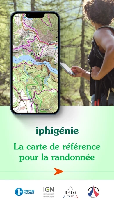
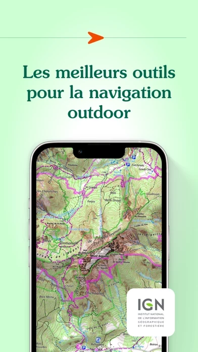
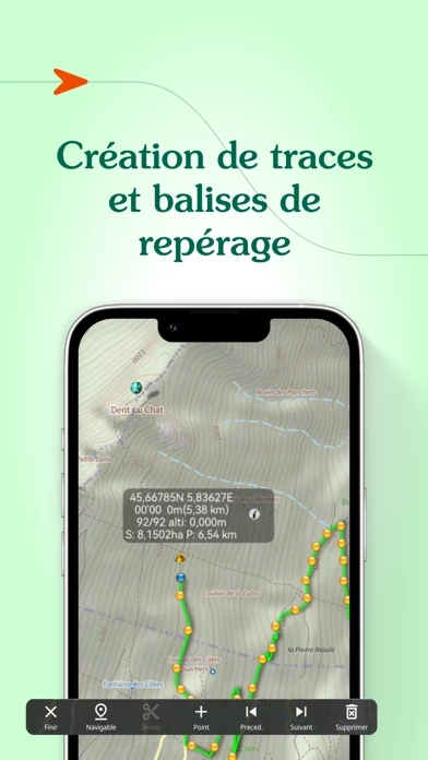
What is Iphigénie | The Hiking Map App?
Everyone understands the need for a map; to prepare for an outing, a walk, a hike, a trip or simply to know where you are and about the environment that surrounds you. Iphigénie is a complete mapping app which - thanks to more than 40 maps - will allow you to find your way anywhere in the world. We include some of the most popular maps in the world: - OpenTopoMap (worldwide topography) - OpenSnowMap (worldwide ski slopes) - French IGN topographic national maps - SwissTopo maps - Spanish topographic maps - Norwegian topographic maps and many others*… But much more than just your location on a map, iPhigénie offers you a variety of tools that will allow you to prepare, follow, record, archive and share your outings. PREPARE - download maps for offline access - create, edit, import GPS tracks - position, import useful markers (e.g. avalanche path, mushroom spots….) - 3D view FOLLOW - follow a GPS track (with optional guidance sounds to keep you on-track) - customised vocal alerts - information like distance covered, distance remaining, estimated arrival time - beacon, to allow chosen contacts to follow your outing progress in real time. RECORD - record your track, your position - information like distance covered, elevation gain and loss, average and current speed ARCHIVE - Tracks and markers saved in a folder - Cloud access SHARE - export your tracks and markers in GPX format By selecting iPhiGéNie, you enjoy not only a complete and stable application, but also a customer-f...