How to Cancel FATMAP
Published by Terrascope Ltd on 2023-12-11We have made it super easy to cancel FATMAP: Ski, Hike & Trail Maps subscription
at the root to avoid any and all mediums "Terrascope Ltd" (the developer) uses to bill you.
Complete Guide to Canceling FATMAP: Ski, Hike & Trail Maps
A few things to note and do before cancelling:
- The developer of FATMAP is Terrascope Ltd and all inquiries must go to them.
- Check the Terms of Services and/or Privacy policy of Terrascope Ltd to know if they support self-serve subscription cancellation:
- Cancelling a subscription during a free trial may result in losing a free trial account.
- You must always cancel a subscription at least 24 hours before the trial period ends.
Pricing Plans
**Gotten from publicly available data and the appstores.
FATMAP Explore
- Pricing: $49.99 per year
- Features:
- Global Topo map or official topo maps from swisstopo, USGS, IGN, basemap.it and more in 3D
- Real-time snow conditions
- Real-time resort status (at supported Ski Resorts)
- Offline maps
- Discounts in major partner brands like Mammut, Salomon, Suunto, Faction Skis and many more.
How to Cancel FATMAP: Ski, Hike & Trail Maps Subscription on iPhone or iPad:
- Open Settings » ~Your name~ » and click "Subscriptions".
- Click the FATMAP (subscription) you want to review.
- Click Cancel.
How to Cancel FATMAP: Ski, Hike & Trail Maps Subscription on Android Device:
- Open your Google Play Store app.
- Click on Menu » "Subscriptions".
- Tap on FATMAP: Ski, Hike & Trail Maps (subscription you wish to cancel)
- Click "Cancel Subscription".
How do I remove my Card from FATMAP?
Removing card details from FATMAP if you subscribed directly is very tricky. Very few websites allow you to remove your card details. So you will have to make do with some few tricks before and after subscribing on websites in the future.
Before Signing up or Subscribing:
- Create an account on Justuseapp. signup here →
- Create upto 4 Virtual Debit Cards - this will act as a VPN for you bank account and prevent apps like FATMAP from billing you to eternity.
- Fund your Justuseapp Cards using your real card.
- Signup on FATMAP: Ski, Hike & Trail Maps or any other website using your Justuseapp card.
- Cancel the FATMAP subscription directly from your Justuseapp dashboard.
- To learn more how this all works, Visit here →.
How to Cancel FATMAP: Ski, Hike & Trail Maps Subscription on a Mac computer:
- Goto your Mac AppStore, Click ~Your name~ (bottom sidebar).
- Click "View Information" and sign in if asked to.
- Scroll down on the next page shown to you until you see the "Subscriptions" tab then click on "Manage".
- Click "Edit" beside the FATMAP: Ski, Hike & Trail Maps app and then click on "Cancel Subscription".
What to do if you Subscribed directly on FATMAP's Website:
- Reach out to Terrascope Ltd here »»
- Visit FATMAP website: Click to visit .
- Login to your account.
- In the menu section, look for any of the following: "Billing", "Subscription", "Payment", "Manage account", "Settings".
- Click the link, then follow the prompts to cancel your subscription.
How to Cancel FATMAP: Ski, Hike & Trail Maps Subscription on Paypal:
To cancel your FATMAP subscription on PayPal, do the following:
- Login to www.paypal.com .
- Click "Settings" » "Payments".
- Next, click on "Manage Automatic Payments" in the Automatic Payments dashboard.
- You'll see a list of merchants you've subscribed to. Click on "FATMAP: Ski, Hike & Trail Maps" or "Terrascope Ltd" to cancel.
How to delete FATMAP account:
- Reach out directly to FATMAP via Justuseapp. Get all Contact details →
- Send an email to [email protected] Click to email requesting that they delete your account.
Delete FATMAP: Ski, Hike & Trail Maps from iPhone:
- On your homescreen, Tap and hold FATMAP: Ski, Hike & Trail Maps until it starts shaking.
- Once it starts to shake, you'll see an X Mark at the top of the app icon.
- Click on that X to delete the FATMAP: Ski, Hike & Trail Maps app.
Delete FATMAP: Ski, Hike & Trail Maps from Android:
- Open your GooglePlay app and goto the menu.
- Click "My Apps and Games" » then "Installed".
- Choose FATMAP: Ski, Hike & Trail Maps, » then click "Uninstall".
Have a Problem with FATMAP: Ski, Hike & Trail Maps? Report Issue
Leave a comment:
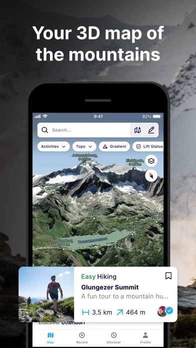
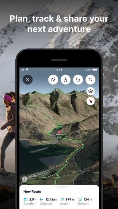
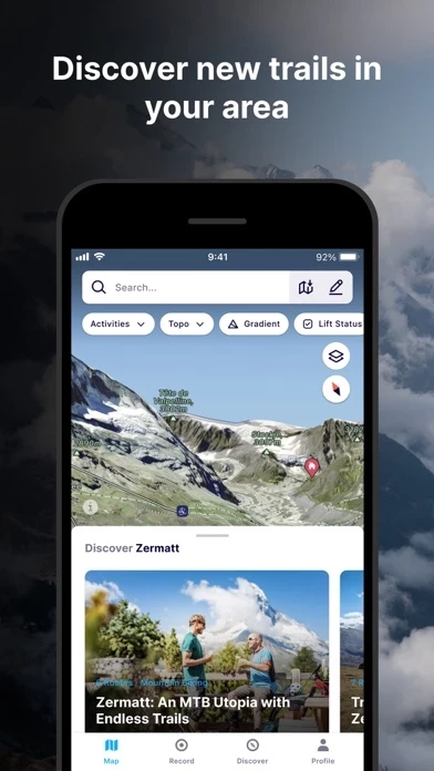
What is FATMAP: Ski, Hike & Trail Maps?
this app is the #1 app for mountain sports. Explore the mountains with confidence with the world's most advanced 3D outdoor map. Plan the perfect route, orientate and navigate along the way, record your day and share it with the community. Whether hiking, biking, trail running, skiing, ski touring or freeriding, if you love mountain adventures, you'll find your community on this app. - Global 3D outdoor map with real-time information and offline maps - Mountain biking, trail running, hiking, resort and backcountry skiing maps - Stunning satellite terrain imagery, in summer and winter - Record and re-live all your adventures in 3D - Advanced terrain analysis tools including slope, elevation, avalanche and more - Follow people to see their latest adventures GLOBAL MAP FOR THE OUTDOORS - Know the area like a local and plan your route in detail with the most advanced 3D outdoor map that helps you intuitively understand the terrain - Find any outdoor trail: footpaths, hiking trails, singletrack and more - Discover outdoor points of interest like mountain huts and campsites - Choose between summer or winter/snow map imagery (where available) FIND YOUR NEXT MOUNTAIN ADVENTURE - Search and find the right route for you or be inspired by the community PLAN & NAVIGATE - Create and share custom locations / waypoints - Locate yourself on the map at any time - Use peak names, roads, footpaths, rivers and heaps of other map data to quickly orientate yourself and navigate to your next objec...