Navionics® Boating Reviews

Navionics® Boating Reviews

Published by on 2023-11-24

About: Get up-to-date, detailed charts you can use offline plus a boatload of features
on your mobile device, so they’re on hand wherever you go. The Boating app is
a must-have for cruising, fishing, sailing, diving and all your activities on
the water.


About Navionics


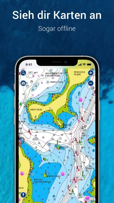
What is Navionics? The Boating app is a comprehensive package that provides up-to-date, detailed charts that can be used offline, along with a range of features that are useful for cruising, fishing, sailing, diving, and other water activities. The app includes internationally renowned Navionics charts, SonarChart HD bathymetry maps, US government charts, overlays, and map options. It also offers tools for planning and enjoying your day, such as auto guidance+ technology, weather and tides, markers, tracks, and distance. The app has an active and helpful community, with community edits and the ActiveCaptain community, connections, GPX import/export, and share map objects. The app is external device-friendly and offers more features such as plotter sync, SonarChart live mapping feature, and AIS.

         

Features


- Internationally renowned Navionics charts

- SonarChart HD bathymetry maps

- US government charts (NOAA)

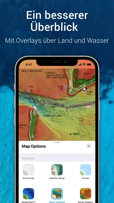
- Overlays: SonarChart shading and relief shading overlays, satellite images, and terrain information

- Map options: Change chart-overlay combinations to customize chart views, highlight shallow areas, target multiple fishing ranges, and more

- Daily updates: Benefit from up to 5,000 daily updates worldwide

- Tools for planning and enjoying your day: Auto guidance+ technology, weather and tides, markers, tracks, and distance

- Active and helpful community: Community edits and the ActiveCaptain community, connections, GPX import/export, and share map objects

- External device-friendly: Plotter sync, SonarChart live mapping feature, and AIS.


Overall User Satisfaction Rating


Positive experience
78.0%

Neutral
61.6%

Negative experience
22.0%

~ from Justuseapp.com NLP analysis of 1,675 combined software reviews.

Key Benefits of Navionics

- Can be used for sailing on-and-off since 1965

- Offers more detail and better accuracy than NOAA or Canadian Hydrographic Service

- Tide and current displays are much easier to use than in any other app

- Device resident, so you only need internet access to update charts


20 Navionics Reviews

3.1 out of 5

By


Saved my life

I had the free app and went out ice fishing on lake Ontario and it was blowing a steady 30. I knew a storm was coming but the fish were biting and i had walked over 3 miles to the spot so i ended up staying way to long. By the time i was packed up there was 3 inches of snow and a total whiteout. i had very little cell service like most places on the lake and started walking the direction i knew was land. After 20-30 minutes i checked google maps to see if it had me almost at shore and it said i had actually over shot the point i went from and was on the east side of it. It was only maybe 1/3 mile away but well after what felt like closer to a mile i checked google maps again to see where i was and it said i was over a mile from land. I then remembered this app and when i used it it showed me about half a mile from what google maps said. I decided to trust this and follow the arrow all the way back for about a mile and see what google maps says. After almost a mile following the this app i started to see dock lights and was relieved. I checked google maps twice walking back and both times it had me over half a mile from my real location. I was out there walking for to two to two half hours between taking breaks and checking for service and i was getting exhausted. Navionics really did save me that night got to single digits and was gusting to 40 plus. Ill probably buy it every year until they stop updating the maps.


By


Navionics Lakes North App

I understand that the support for Navionics was rendered unusable due to IOS updates and that there are no plans to update or replace. When this app decided to market via the Apple Store for IOS products I would have thought the need for updates would have been recognized. So I purchased Navionics which was fantastic and perfectly suited for my area. When it stopped working I was very disappointed but understood the need for IOS updates and patiently waited. After more than a year I sent and inquiry to this app about the status for Navionics. I was informed that there will be no update to allow Navionics to work but that other Apps were available, “for purchase”. In reviewing these options I found them not suitable for my Region. I know this app has a variety of marine navigation hardware on the market that, for a price, can service my needs nicely. The rub is that I can no longer trust them. I purchased software they offered, then they decided to discontinue support with the option of “purchasing” other Apps. How can I trust them not to terminate support for any of the hardware/software they are marketing after I “purchase” these items. I know this app to be a competent provider of Marine Navigation system but can no longer trust their after market support.


By


Would be perfect is orientation fixed

Honestly, this is a near perfect app! With one fix, it would be invaluable for safe boating! My family and I deeply appreciate the way it shows water depth accurately with many ways to personalize the system (examples: preferred units of measure and color coding). It has impressive features, including a way to have it adjust for when the water level is down any number of feet.

There is only one problem: the default orientation is “North Up.” It causes major frustration and increases potential danger as it requires boat drivers to spend extra time staring at Navionics . We’ve tried unsuccessfully to set it for “Heads Up” orientation (so it matches the left/right of the boat’s reality). In Settings, we select “Heads Up” display, but it quickly returns to “North Up.” It’s a serious frustration and big disappointment.

They should fix it to lock in the display orientation we select and/or change the default to the user-friendly “Heads Up.” Please!


By


Pretty Amazing

I’ve been sailing on-and-off since about 1965 and I’ve using Navionics on my iPad for only a few years but I now can’t really imagine sailing without it. It can be quirky to learn initially, but it is astounding what it can do and worth the time spent at home learning how to use it. I believe the company and its new customers would benefit from a mini video course using a series of short videos to train people how to best use Navionics . I’m sure there are many things I’ve yet to learn.

Here’s a tip: When you’re at home playing with Navionics , learning it, turn off location services on your iPad settings for Navionics so it doesn’t keep wanting to bring you home (instead of out on the water where you’re pretending to be). (Note to this app: a training mode would be useful to accomplish this.) Don’t forget to turn location services back on when you head out on on the water.


By


Still Trial...heading mode all is upside down

When I go in heading view (and heading south in this example), all the legends and info on the chart is upside down. Is this as intended? I also fly an airplane, and all GPS's including a GNS 430 keep the info upright and legible regardless of North Up or Track Up.

To developer's response: goodness, man, we are driving a boat through moving water...what would make you think all that data is LESS important just because we want where we are going in front of us? Especially depths. Yes, please change that. There wouldn’t be a single boater in a thousand who would disagree.

The more I think of it, the more ridiculous this is. We all drive cars with GPSs in them...even the developers do...who ever HEARD of a GPS that would present legends to you upside down! Talk about missing the point of a GPS system. My god.


By


I can’t read the DEPTH

What is the one thing you need from a chart but can’t get from just sitting in your boat ? WATER DEPTH. So, I bought the $15 subscription and kept this as a digital plan B when out on the water. When I tried to use it on the water (not an ideal reading environment ) I had to stop the boat and zoom in and out so the water depth was shown in a font bigger than 1cm.

When zooming, the iPhone will digitally zoom and increase the depth markings to a readable size. Then Navionics redraws the map at a higher magnification and dutifully represents depth in the smallest font possible. I could not see depth on a iPhone plus. Why can’t this be set as a user option????

By the way, the finger pinch is generally interpreted as a “move to a location 100 miles from here...”. Navionics is too mature to suffer from basic user interface problems like this. Can’t the developer just clone a fishfinder/gps user interface? Garmin has one, and Garmin owns this app. Why sell an app that sports a half-baked user interface?

But if you are sitting in a dark room with reading glasses, have plenty of patience, and perfect the pinch maneuver, you can scope out some new waterways with Navionics. Better yet, use the web browser interface for free and on a HUGE monitor you will be able to see depths. And you will avoid pinch vs move user interface confusion.


By


Sacramento Delta Fail!!

I have tried for a few of years now to get the routing feature to work on this boating app and an earlier this app app including emails to tech support and I can say that it has been a big waste of time. The routing feature can load for 45 minutes on a route that is just over 30 miles only to finish with a “too many way points“ message when no way points have been selected. Maybe Navionics works better on a wide-open body of water with simple routes but here in the Sacramento Delta it is an abject failure. Complete and total failure. Please let people know that your app just does not work for short trips with multiple choices for routes. Period. Otherwise you are wasting people’s valuable time regardless of how cheap Navionics is. I would love to see an app with 5% of the efficacy of google Maps for the roadways. Is there one?? Anybody?? Navionics and possibly others just will not route a trip for you. Please don’t waste your time like I have!


By


Expensive and deceptive

I bought Navionics years ago. I used it for planing kayaking trips. It was great back then. It included all the data. There was no subscription fee. It was EXPENSIVE at the time; the most expensive app I’d ever bought. I think it was $48. I hadn’t used it for a while. Now I had to pay for a subscription to use it. None of my data is there. Not only that, but the subscription price doesn’t include any data. No nautical chart is included in the subscription price! You have to pay an additional $15 for a nav chart “overlay.” And to get both US and Canada (which my subscription was supposed to cover) I need to buy two overlays. What once was a great app is now a very expensive subscription service. It might work for you if you use this on a yacht and can afford it, but for paddling I guess I’m going back to paper charts. It’s not worth it.


By


5 years, 34,000 nautical miles

We have used this app for 6 round trips on the ICW. We have used this app in Canada and the Bahamas. The charts are excellent and the Sonar Charts offer more detail and better accuracy than NOAA or Canadian Hydrographic Service! autoroute has many uses. The tide and current displays are much easier to use than in any other app we have used. All this is device resident, so you only need internet access to update you charts. This can be done easily and quickly over a cell phone connection. Navionics also will connect over the internet to the sea buoys for real time wind and wave conditions. No other navigation app has near the functionality and power as this one.


By


Very useful. Could be great with a few small changes.

Use Navionics daily working full time on a sailboat. Very useful for route planning in conjunction with boat’s MFD. Great customer service, will work with you to fix any bugs (or which there aren’t many). Wish they had the option to offset the boat on the screen as you can in a hard wired GPS so the boat icon isn’t in the middle of the screen, but instead gives you more view of where you’re going (maybe 1/4-1/3 of screen where you’ve been, 2/3-3/4 where you’re going). Makes user experience much better, less moving the screen around as you’re sailing and instead just leaving the boat centered. Been using our iPad a lot recently as our boat’s MFD is malfunctioning, and this change would be awesome.


By


Needs some attention. Please fix it.

Several years ago this was the best. Now it does not stack up. It has not improved in 3 years. My biggest complaint is that I cannot use it on the intracoastal waterway on a leg of more than 20 miles. That makes it useless as a planning tool. It constantly throws a “too many points” error message on a leg of any length. I have a slow sailboat, but I still can make 40-60 miles in a day. This needs to be fixed or I will not renew.

I received a relatively lame response and was send to a web address to learn than a route is limited to 200 points. I was told to break my day into multiple legs. That is not “dock to dock routing.” That is a pill. If you have ever seen their routes you can see that a route should be 2000 points, not 200. This should not be a difficult change for this app.


By


App won’t open!

Downloaded app and used it for 2 weeks on iPhone and it worked fine. Then all of a sudden when trying to open I got the blue this app screen for 1 second and then crashed. I am tech savvy and tried everything, deleted app and reloaded, cleared cache on phone, freed up space on phone, rebooted phone all to no avail. Definitely seems like a bug in Navionics . I contacted customer service via email and got one very unsatisfactory reply. Navionics is necessary for volunteer work I’m doing but am totally stuck with what seems like no help!
ADDENDUM: this app responded recognizing the problem and stated they are working on it with urgency. Glad to see the company is responsive.


By


It Used To Be Great

As I said, used to! The programmers of Navionics obviously aren’t boaters. I’d invite them to come ride along on my 22 foot Baja traveling at 62 mph, crashing into the waves and just TRY to fight with this piece of JUNK on an iPhone XS Max. The buttons are way too small to press. The freaking “track UP” won’t stay put, but randomly switches to “North Up”. On a 20 mile trip I had to continuously keep setting it for TRACK UP. It just wouldn’t stay as I wanted it. Why can’t it be set to LOCK track up? I also have to break our trip up into multiple segments because it won’t plan the entire trip at once. Please, PLEASE, PLEASE get this thing useable.
If y’all don’t have a clue of how to improve Navionics , take a good look at the Foreflight app group. They continuously improved that app by listening to the actual users.


By


Amazing software

I can’t believe all the negative reviews Navionics gets. I’ve used it for six years as a liveaboard sailor. We’ve sailed from Maine to the Bahamas and Caribbean as far as Dominica multiple times and its been incredibly accurate, much better than the charts on my new Raymarine chartplotter, which cost five times as much. I chart all my routes with Navionics and follow it using my iPad. I just use my chart plotter as a backup. If I had to give up one, it would be the chartplotter. Keep up the great work guys and gals. As for the naysayers I’ve got a barely used sextant I’ll sell you for cheap.


By


Problem With New Update

The new update has screwed up the fuel usage projection that appears in the trip detail. If one opens a saved route and presses “details” there appears at the top the mileage and time to destination and projected fuel usage. The latter is based on the burn rate Navionics user entered via the boat settings by going to Menu>>Me>>Boat Settings>>Fuel Consumption. Thus if one entered a burn rate of 26 gallons/hour and the trip is 45 minutes the projected fuel usage should be 19.5 gallons. IT SHOULD NOT BE 71.7 GALLONS WHICH APPEARS AFTER THE NEW UPDATE. I hope this clarifies my prior review and would prompt an immediate update to fix a serious problem.


By


What Happened?

I have used Navionics for several years and it has been stable and easy to use. This new version has added all kinds of automatic features that make the experience repetitive and just plain bad. Why does the map zoom out when I select an item? I have to zoom back in to see the detail again. What happened to the route creation where you would add points as you go and see your fuel consumption? Now it automatically adds a final point and you have to move it out of the way when creating waypoints and there is no fuel usage information. I paid for 2 subscriptions and after the third crash neither are loading so all I get is a blank chart and pop-ups asking for more money. Navionics doesn’t even deserve 1 star. I feel robbed!


By


Wanted: split screen and low speed heading

First of all, I really like Navionics. I have my iPad mini in a mount on my little Boston Whaler.

I wish that this had split screen capability. I run Mercury Vessel view. This lets me get all sorts of engine parameters via a bluetooth module on my engine. I can use slide over, but I wish Navionics had split screen capability.

I showed myself going down a canal sideways at 4kts. It would be great to use the gps track as opposed to the compass heading at a much lower speed. I’ll throw the request out there, but I have the feeling that this is not something the developers have control of.


By


Frustrating app

This is one of the most frustrating unintuitive apps I have ever used. The directions on the side do not match what you see on the screen, that is extremely frustrating. Especially when Navionics does not work like you would think it would. If you are creating a route you should be able to"save" the route. That is not how it works you're supposed to press route again, completely unintuitive. The other way to save her route is to actually press start, but I don't want to start the route this is a row I'm creating for the future. But this is the only way to save the route. Even though Navionics says I have two routes I only have one. Extremely frustrating will not be renewing my subscription


By


Love this app

Reading some of the other reviews, looks like the poor ratings correlate to user error. Navionics is awesome. At $9.99 a year, it does everything an over priced lowrance or humminbird would do, except with this I get over the air updates and don’t have to mess with fumbling around with memory cards.

I’ve always found it extremely easy to use, I love being able to download maps offline, and it’s eerily accurate.

That said, with a 5 star rating, I have some quick constructive input to offer the devs:

1. Make it easier / quicker to drop a pin on the map. A quick button on the main map screen would be great

2. Would like to see the new “fishing ranges” feature go all the way down to 0’ instead of 4’ for the minimum

3. Wish there was a way to text a route to others who use Navionics , instead of e-mailing.

Minor stuff, but would put it over the top! Great job to this app and everyone involved on Navionics.


By


Warning, forced subscription. Cloud and big data ahead.

With the last update, Garmin is now forcing users to create an account before allowing access to Navionics . Even if you have a current subscription purchased under the old model. They are claiming the community asked for it and it was done solely to share subscriptions and stored data across devices. However if this was truly the case, they could have easily made use of an account optional. One has to wonder what exactly they are up to with user data. Garmin folks: this practice violates trust with the user community and will result in loss of market share when the next option comes around. Please consider supporting all your user types, not just adjusting policies to what the business guys say provides the best return on investment.


By


Loved the old app (Boating HD)

Loved the old boating had app.
New app, not so much.
$21 a year and then you’re going to spam me with in app purchases?
Old app works better at showing your saved spots. Navionics gives you the depth when you hover over a saved spot. It won’t give you spot name unless you wiggle over it a while or go to ? Screen. How useful is that when bouncing in a boat?


By


Beware when you renew subscription

The this app app continues to be misleading when you try to renew your subscription. I renewed my subscription to US and Canada, but Navionics continued to display “Subscription Expired” and a button to “USA Charts”, no matter how many times I restarted and re-synched Navionics . Eventually, out of desperation, I clicked the “USA Charts” button, so I got subscribed to USA as well (which are already included in US and Canada). I really feel that the UI misled me. I emailed this app, explaining what happened and asking for a refund on the second purchase, but no reply.
this app charts are good, but I am so tired with this app behavior, their in-app purchases are just misleading, they do not follow Apple’s guidelines, and have been this way for a long time. I did report them to Apple, if you have similar problems do the same.


By


Navionics not as good as before

We have been using this app for a few years and loved it. The charts and nav functions worked great while cruising SE Asia, Japan, Alaska, and even a run from Annapolis to the BVI. But a while ago we got the notice we needed to upgrade to Boating. As we had such great luck with this app we paid our fee and did so. I am regretting it. The new version has GPS issues and often corrects dropping velocity and heading. The new programmer obviously knows little about GPS or cruising. I believe his Kalmen filter doesn’t load properly and when it resets it all goes to zero. I will be looking for another program. Note we have run this side by side on three devices. They all have the same problem but do not do it at the same time so I am making the assumption about the filter.


By


Painful

We are planning a crossing of the Indian Ocean, Red Sea and Mediterranean this fall. I took the time to download all the potential areas that we might enter. Using a very expensive yet slow and unreliable internet connection here in Malaysia it took weeks to get all the little squares selected and downloaded. But I was persistent and got them all downloaded and thought I was ready to go. Now they have disappeared, gone! This is totally not a good situation, we could be weeks away from land and any internet or phone tower. When you are in the middle of the ocean, doing a new download is not an option!

I just now checked my iPad, I had taken the time to download, using that tiny little download box, I worked my way all the way around Africa and through the Med charts. It was all loaded for offline use. Now the Africa charts are gone!!

Two separate devices. Different missing charts. This is just a very frustrating application. Now it will cost me time and money to download all the charts again!! Is it worth it?

You cannot rely on the charts you need to be on your devices. I would highly discourage anyone from purchasing Navionics or charts.


By


Route/Track Header toggle

***update to developer response. ***********
Yeah, that is the problem. ONLY the track info is available in the header.
The previous versions had a TOGGLE between track info on ROUTE info.
The route info in the header had such info as time and mileage to the next route point.
Without that, you have to do a lot of work to get that info.
It was nice to have it quickly available.
**********************************************

I used boating USA app to sail from New Orleans to Guatemala. It was a truly valuable app. Although I had other navigation systems to rely on as back up, I never used them.
I will likely use Navionics again, next season, to continue down to Panama.

The updates make the functionality different, and I'm sure I will learn it. If I can make one request, it would be to put back the Header Toggle between Route and Track info.
Having that info available so quickly was very handy. That Header held a wealth of useful info, that just isn't there in the update.
Bring that back, and you'll have a great product again.


By


iOS updates rendered old app useless without notification

I too am extremely disappointed in app support from this app!! The very least the company should have done, since they knew well in advance they were changing from a 32 bit app design to a 64 bit design, was to notify existing (who paid $9.99 for app) customers of the change coming!! Since that was not done, they also missed an opportunity to keep existing customers with a discounted “buy-in” of the new product. For these reasons I will never buy a mother this app product be it app or equipment for my 5 million yacht. Fool me once shame on you, fool me twice shame on me! Not gonna happen. Next they will replace current 64 bit app with a 124 bit app, be ready for it.


By


No more US Govt NOAA chart viewing!!!

Taking away the ability to view/use the Govt NOAA charts is the last straw example of this company’s greed. Many of us use those charts for planning but only buy your subscription Charts for areas we will actually sail in. In my case I buy the Caribbean chart subscription, but still want to look at several US locations so I use the Govt NOAA charts for that. It also looks like your Caribbean Charts subscription has increased from about $8 to $28 per year. That also seems greedy and price gouging, at the very least for us customers who have been loyal and supported this app for years. If you don’t decide to give us those Govt NOAA map viewing and reasonable subscription fees back, then its time for many of us to find a new Chart app !!


By


Not a one time pay app like they said.

I have been using Navionics for about three years now. I bought it when it was offered at a one time buy. But for the past week, my maps and all the depth contours that were once included have no longer worked. My pins are still available but the lakes will no longer load when I zoom. The basic outline is there but only in straight lines. Very disappointing. I’ve emailed the support team. I’m hoping this is just a glitch and not something I have to pay again and again for like Navionics is asking me to do. If so I’m going a different route.


By


Ok. Room for improvement

Just got it. Nice so far. But please, PLEASE move the image/map copyright links farther off the center of the map. I’m getting really sick of the website opening every time I zoom in or out. There’s no reason they need to be where they are.

Update: received response from the developer stating that they have to have those links for the terrain overlay because it’s not their map data. Well no I don’t think so, many other apps have that in a settings menu. But that doesn’t address the poor placement or almost invisible color. So it gets tapped every zoom attempt. Dropping to 1star based on ridiculous developer response.


Is Navionics Safe?


Yes. Navionics® Boating is very safe to use. This is based on our NLP (Natural language processing) analysis of over 1,675 User Reviews sourced from the Appstore and the appstore cumulative rating of 3.1/5 . Justuseapp Safety Score for Navionics Is 78.0/100.


Is Navionics Legit?


Yes. Navionics® Boating is a totally legit app. This conclusion was arrived at by running over 1,675 Navionics® Boating User Reviews through our NLP machine learning process to determine if users believe the app is legitimate or not. Based on this, Justuseapp Legitimacy Score for Navionics Is 100/100..


Is Navionics® Boating not working?


Navionics® Boating works most of the time. If it is not working for you, we recommend you excersise some patience and retry later or Contact Support.


Pricing Information

**Pricing data is based on average subscription prices reported by Justuseapp.com users..

- One-year renewable subscription for access to detailed charts and features on the Boating app

- Pricing not specified, but a limited-time free trial is available before purchasing the subscription


How was your experience with Navionics® Boating? Post a Review

Leave a comment:


Alternatives