PhoneMaps Reviews

PhoneMaps Reviews

Published by on 2021-12-07

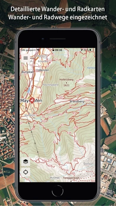
🏷️ About: The PhoneMaps app is a hiking and cycling app that offers free zoomable maps with a full network of marked hiking and cycling routes across almost the whole of Europe. The app allows users to plan their holiday, orientate themselves during the activity, record their tracks and experiences, and share them with friends. The app offers detailed hiking and cycling maps, including marked hiking and cycling routes, which are not available in general map applications on your phone.


Overall Customer Experience 😎


😎👌🔥 Positive experience
52.7%

👿🤬😠 Negative experience
32.2%

🙄💅🫥 Neutral
15.1%

~ from Justuseapp.com NLP analysis of 27 combined software reviews.


Summary of Customer Reviews (Takeaways): 💎

- Offers useful guides and walks for Madeira

- Provides bike map option

- Always accessible in case of emergency or unexpected change of plans


Read 2 Customer Service Reviews 👿🤬😡😠💢😤

4.6 out of 5

Good to have, close to very good

2022-06-09

I use PhoneMaps to have a bike map option on me. Most of my routes are well known to me at this point. If I go somewhere new, I take a paper map with me.

But PhoneMaps is good to have in a pinch. Something is divert and this is always on me.

Two things would make it better. First, I have to figure out which of the many maps I have downloaded applies. If I pick wrong one, close and go to another. I'd like instead for all touching maps to merge if I have purchased already to avoid this. I mean this is electronic and I am still deal with being in the crack! Second, though perhaps too ambitious, enable some function to find new routes.

Anyway, if I had to do over I would still get PhoneMaps and purchased relevant maps.

Advanced hiking maps with poor UI

2022-07-10

I am on Madeira at the moment and this app offer a lot of useful guides and walks. Hovewer, the UI does not feel intuitive and native to iOS when navigating through Madeira Guide.

Please make all guide photos browsable at once without needing to click on all walk POIs separately.

Also please add that when I hold 2 fingers on map it will show distance between them, that would be very useful!


Is PhoneMaps Safe? 🤗🙏


Yes. PhoneMaps is very safe to use. This is based on our NLP (Natural language processing) analysis of over 27 User Reviews sourced from the Appstore and the appstore cumulative rating of 4.6/5 . Justuseapp Safety Score for PhoneMaps Is 62.1/100.


Is PhoneMaps Legit? 💯


Yes. PhoneMaps is a totally legit app. This conclusion was arrived at by running over 27 PhoneMaps User Reviews through our NLP machine learning process to determine if users believe the app is legitimate or not. Based on this, Justuseapp Legitimacy Score for PhoneMaps Is 79.8/100..


Is PhoneMaps not working? 🚨


PhoneMaps works most of the time. If it is not working for you, we recommend you excersise some patience and retry later or Contact Support.


How was your experience with PhoneMaps? Post a Review


Features

- Available in English, German, Czech, Slovak, Polish, Italian, Portuguese, Slovenian, Dutch, and Chinese

- Offers online and offline maps

- Covers almost the whole of Europe up to a maximum map scale of 1:5,000

- Detailed hiking and cycling maps include marked hiking and cycling routes

- Maps created by cartographic companies freytag&berndt and SHOCart

- Offers hiking and travel guides from Bergverlag Rother and freytag&berndt

- Vector maps are smaller and easily zoomable and rotated

- Allows users to download maps of the area they plan to visit

- All points in maps have interactive information such as address, website, email, timetable, etc.

- Interactive tourist attractions in maps with photos and texts

- Shows current GPS position

- Allows locality searching

- Offers record/import/export/management of user routes (gpx)

- Allows users to record user points of interest

- Spatially localized taking photos in the app

- Offers online routing and searching of optimal routes in a map (for hikers, cyclers, cars)

- Provides statistics of routes and elevation models of routes

- Offers hiking/cycling maps till 1:5,000 for Andorra, Austria, Belgium, Bulgaria, Croatia, Czech Republic, Denmark, Estonia, Finland, France, Germany, Greece, Ireland, Israel, Italy, Hungary, Latvia, Lichtenstein, Lithuania, Luxembourg, Monaco, Montenegro, Netherlands, Norway, Poland, Romania, San Marino, Spain, Slovakia, Slovenia, Sweden, Switzerland, United Kingdom, USA, Nepal, Japan, Taiwan, New Zealand, Israel, Kilimanjaro

- Offers topographic maps 1:5,000 for the rest of the world

- The app and all maps and functions are free to use.

  Customer Service/Support
Developer:
freytag & berndt