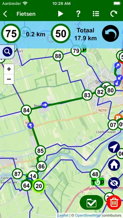
Fietsknoop bike and hiking app Alternatives

Fietsknoop bike and hiking app Alternatives

Published by on 2024-01-18

Find best apps like Fietsknoop bike and hiking app, competitors and top software/SaaS apps in this
category. Use the bike and hike nodes system in The Netherlands, Belgium and the borders
of Germany to plan your own bike routes. After you make your route you can save,
mail and share it. You can use...


40 Best Alternatives To Fietsknoop bike and hiking app

What are the best software like Fietsknoop bike and hiking app for 2024? Below are the most similar Navigation softwares we found.


SmartHalo - Bike smarter.
Bike smarter with SmartHalo, a minimalist, award-winning, circular interface that pairs with your iPhone to elevate your cycling experience. This is the smart biking device you’ve been waiting for...

Citi Bike
The official app for Citi Bike, NYC’s bike share system. Citi Bike consists of a fleet of specially designed, sturdy and durable bikes that are locked into a network of docking stations throughout the city...


Boston Bikes
Unofficial application to view detailed information about the stations of the BlueBikes bicycles rental service in Boston. - Map of the city with the position of stations showing the number of bikes and the free stands for each station...

Maps 3D - Hike & Bike
Enjoy exploring the great outdoors? If you’re a fan of biking, hiking and running then Maps 3D is the ideal app designed for planning your outdoor adventures. Whereas other mapping apps are primarily designed for cities and roads, displaying hills and mountains as flat and lifeless features, Maps 3D is packed with amazing features that brings the great outdoors to vibrant life with valleys, hills, mountains and footpaths dis...

komoot - hike, bike & run
Turn your next ride, hike, or run into an adventure with komoot. Get inspired by tapping into shared community knowledge and recommendations, then bring your adventures to life with the easy route planner...

ViewRanger: Hike, Bike or Walk
ViewRanger is now Outdooractive. Goodbye from us...

Bluebikes
Bluebikes is metro-Boston’s public bike share system. With over 2,500 bikes available 24/7 at more than 260 stations throughout Boston, Brookline, Everett, Cambridge, and Somerville, Bluebikes is one of the most popular bike shares in the country...

TrailLink: Bike, Run, Walk
TrailLink is the ultimate trail-finder app to help you stay active and get outdoors. Enjoy full-length trail descriptions, reviews, photos, and detailed trail maps not found anywhere else! Discover amazing trails near you that are perfect for cycling, jogging, walking, workouts and more...

Metro Bike Share
Metro Bike Share is now available in Downtown Los Angeles! With up to 1000 self-service bikes and up to 65 stations available 24 hours a day and 365 days a year, Metro Bike Share offers convenient round-the-clock access to a fleet of bicycles for short trips and to get to transit on your schedule. Metro Bike Share is an additional public transportation option for Angelenos and visitors to get around Downtown Angeles...


Bikemap: Bicycle Route & GPS
Do you love to discover, navigate, and track new cycling routes? Then you'll love Bikemap. It doesn't matter if bicycling for you means a leisurely ride with your city bike or e-bike, climbing MTB trails with your mountain bike, or preparing for your next cycling marathon...

Divvy Bikes
The official app for Divvy, Chicago’s bike share system. Divvy consists of a fleet of specially designed, sturdy and durable bikes that are locked into a network of docking stations throughout the city...

Geovelo : bike GPS
Geovelo, your dedicated GPS for bike ! DEDICATED ROUTES The application take care of your bike type, your speed, the desired type of course (from fastest to most secure). Geovelo chooses, first and foremost, cycleways, bike lanes and low traffic streets to ensure comfort, safety and serenity...

Indego Bike Share
Indego bike share is an initiative of the City of Philadelphia, with hundreds of self-service bikes and and more than 100 stations throughout the city. The official Indego app allows you to check bike and dock availability, purchase a pass, log into your account and contact customer service by chat, phone or email...

KVBike
KVBike ist eine App, die den Live-Standort der frei verfügbaren KVB Räder in Köln anzeigt. Es wird eine Stadtkarte mit Markierungen dargestellt, welche sowohl den Ort der Räder (rote Markierungen) als auch den der Ausleihstationen (blaue Markierungen) anzeigt...

BULLS Connected eBike
Bulls eBike integrates e-bike, mobile and cloud computing technologies into a complete new e-bike experience. Check in the instruction manuals or with your e-bike retailer if your e-bike integrates the ESB Technology...

Google Maps
Navigate your world faster and easier with Google Maps. Over 220 countries and territories mapped and hundreds of millions of businesses and places on the map...


Waze Navigation & Live Traffic
Always know what’s happening on the road with Waze. Even if you know the way, Waze tells you instantly about traffic, construction, police, crashes, & more...

ParkMobile: Park. Pay. Go.
With over 20 million users, ParkMobile is a smarter way to park. Easily pay for street, lot, or garage parking right from your mobile device...


Transit • Subway & Bus Times
"Gives you the best route to where you want to go" - New York Times “You won't realize how much time you can save planning until you use this app” - LA Times “Killer app” - WSJ "MBTA has a favorite transit app — and it's called Transit" - Boston Globe Transit is your real-time urban travel companion. Navigate your city’s public transit system with accurate real-time predictions, simple trip planning, step-by-step...

SpotHero: #1 Rated Parking App
Park smarter with the SpotHero iPhone app. SpotHero helps you get everywhere, easier by making it fast and convenient to find and reserve parking in major cities...

HiiKER: The Hiking Maps App
HiiKER is the hiking app that is dedicated to building tools specifically for the hiking community. More than just a map and a compass, the app enables you to hike in the great outdoors with confidence, now with free offline maps...

Outdooractive: Hiking Trails
The Outdooractive App for iPhone, iPad and AppleWatch is the perfect companion for hiking, cycling and other outdoor activities. With the app you can find and plan routes around the world with ease...

Iphigénie | The Hiking Map App
Everyone understands the need for a map; to prepare for an outing, a walk, a hike, a trip or simply to know where you are and about the environment that surrounds you. Iphigénie is a complete mapping app which - thanks to more than 40 maps - will allow you to find your way anywhere in the world...

Hiking & Skiing - PeakVisor
PeakVisor will make you a superhero of outdoor navigation by putting state-of-the-art 3D maps and mountain identification magic wand in your hand. "PeakVisor uses your iPhone's camera and augmented reality (AR) technology to display names and elevation of nearby peaks...

Hiking & biking in SW Germany
Baden-Württemberg – The sunny side of Germany Welcome to sunny SouthWest Germany, a very special vacation destination. Start with historic cities...

neanderland STEIG Hiking App
This app is the perfect companion and tour planner for your hike on the neanderland STEIG. It contains all the important information about the route, restaurants and sights...

IGNrando' – France hiking maps
IGNrando’ is a French collaborative platform offering curated data and services related to outdoor activities. RICH DATA OFFER • Tens of thousands of available routes accross Metropolitan and Overseas France • Choose the activity, difficulty and length to find routes around you or near any other place • Download routes or mark them as favorites MAPS IN FREE ACCESS (with internet connection) • Plan IGN: most updated...

Topo Map & Hiking Tracker
** The #1 Hiking Tracker App for iOS ** TRACK YOUR STATS! + Total distance + Total vertical + Total time + Calories burned * Optimized to save battery life VIEW YOUR TRACKS! + Recap your hike on the map + Color coded tracks based on relative elevation + Quickly view stats on Apple Watch display + iOS 14 home screen widget BACKUP TO iCLOUD + Automatically backup data to iCloud + Share data between devices THE BES...


KOMPASS Outdoor & Hiking Maps
Wo der Asphalt endet, beginnt die Welt von KOMPASS. Die ganze Welt von KOMPASS gibt es in unserer KOMPASS-Wanderkarten-APP...

Polly
We know parking is frustrating. It really does not have to be that way...

GPS Tracker GPX Viewer GCS UTM
Create, import, export tracks with waypoints. Supports offline maps, no time limits, no ads, no in-app purchases...

Parkaroo
Quickly find on-street parking with the Parkaroo iPhone app. If you are frustrated weaving through city streets looking for parking or paying for an expensive garage, Parkaroo is the app for you...

Qibla Pro - Prayer Direction
Qibla Pro accurately finds the exact direction of Qibla (Kaaba) from almost anywhere in the world. Qibla Pro is the one of the most accurate qibla finders! Experience the elegant and smooth flow of the compass that will direct you to the correct location of Kaaba...

Find my Phone, Friends - iMapp
iMapp will help you track your friends and relatives who are connected to the service as well as assist you in finding a person's location by request, regardless of whether they have the app on their device installed. Now, you no longer need to call each other dozens of times to arrange a meeting, you can simply view each other’s locations via a phone number...


onX Hunt: GPS Hunting Maps
onX Hunt has been featured in Field and Stream, Outdoor Life and American Hunter as the best hunting app, hiking app, and GPS app for any outdoorsman or hunter. Used by millions of US hunters...

ParkWhiz - #1 Parking App
Take the hassle out of parking with the ParkWhiz app. Find parking in any major city, compare prices, plus save up to 50% when you book in advance...

Exxon Mobil Rewards+
The most secure and easy way to pay for fuel and earn rewards. Exxon Mobil Rewards+ app allows you to stay in the comfort of your vehicle while you pay for Synergy™ fuel with your phone...

Chevron
...


Avenza Maps: Offline Mapping
Avenza Maps, #1 app for hiking, biking and all trails. Featuring maps from National Geographic, national parks and more! On your next adventure, stay on track with GPS using offline mobile maps...


Most Popular Apps in Navigation