iNavX: Marine Navigation Reviews

iNavX: Marine Navigation Reviews

Published by on 2023-11-29

About: Marine navigation is made easy with iNavX - the world's #1 handheld
Chartplotter. Access marine charts, maps, weather, AIS and more! iNavX is the
only app to give you complete worldwide chart coverage, from all your favorite
charts providers, including the ALL NEW iNavX Professional+ Global Chart! Fully
enabled with one-touch access, iNavX gives users access to the broadest set of
marine charts and maps from multiple provide.


About iNavX


What is iNavX?

iNavX is a handheld chartplotter app that provides complete worldwide chart coverage, weather forecasts, AIS integration, and more. It is designed for sailors, boaters, and anglers to plan sailing routes, manage boating equipment, and discover new fishing spots. The app is compatible with various chart providers and nautical instruments, and it offers advanced features such as real-time GPS positioning, route planning, track logging, and data import/export.


Features


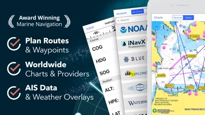
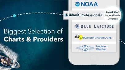
- Complete worldwide chart coverage from multiple providers

- Plan sailing routes with waypoint and route management

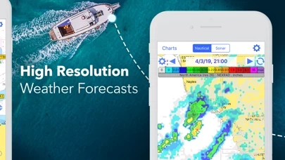
- Get proactive sail management with GRIB weather forecasts

- Keep watch with AIS overlays and integration with onboard systems

- Geotag photos to remember great sailing locations

- Stay up to date on boating conditions with forecasts that include currents, winds, and swells

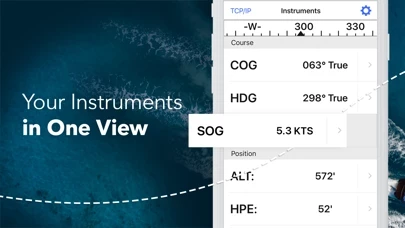
- Manage boating equipment with nautical instrument integration

- Save great boating routes to share with the track log

- Discover new fishing spots by scouting out holes and inlets

- Identify cold fronts to locate the best fishing conditions

- Save best fishing spots with unlimited markers

- Real-time GPS positioning with pan, zoom, and rotate charts

- Print detailed charts to use in combination with the app

- Create waypoints and plan routes to navigate between them

- Record your route with the track log

- Import/export data in KML or GPX format

- Supports NMEA data over TCP/IP using Wifi

- Integrates with external GPS, AIS receivers & transponders

- Connect nautical instruments: Depth, Speed, Wind, Engine, Batteries, etc.

- GRIB weather forecast, tides/currents, anchor alarm, AIS integration, port/navaid search

- Complimentary copy of the official and up-to-date high-resolution NOAA RNC United States marine raster charts upon download

- Compatible with various chart providers and nautical instruments

- Chart subscriptions vary by chart and provider from $9.99 to $199.99 annually, charged to your iTunes Account

- Auto-renew can be turned off anytime by going to your Account Settings in iTunes after purchase

- Continued use of GPS running in the background can dramatically decrease battery life.


Overall User Satisfaction Rating


Positive experience
62.9%

Neutral
44.6%

Negative experience
37.1%

~ from Justuseapp.com NLP analysis of 18,296 combined software reviews.

Key Benefits of iNavX

- Reliable and accurate

- Easy to use

- Seamless stitching of charts

- Low cost alternative

- Can use old NOAA raster maps for free


20 iNavX Reviews

4.8 out of 5

By


Circumnavigated in 2 yrs

Found this app to be very reliable and accurate everywhere we went, French Polynesia to N Australia, Indonesia to India, Red Sea through Mediterranean, Cape Verde to the South American Giuanas, Southern Caribbean to Panama, now up the Central American & Mexican Pacific coast. I highly recommend it as a compliment to a chart plotter. Charts for our B&G chart plotter are expensive so I don’t buy them and just use the generic world chart that comes free with the chart plotter. I subscribe to the this app Navionics charts per region as needed, and then plan my routes on this app, with all its visible detail, and transfer the waypoints to my chart plotter. I use iPhone 6 Plus but maybe a tablet, with its larger screen, would be better.

Be great if someday PredictWind GPX’s could somehow be imported and managed.


By


Good App, but...

We have used iNavX for two years now, sailing out of St. Augustine, FL, and now bound around the world on our 35' sailboat. iNavX has many nice features and it has gotten us through the Caribbean, now 3,000 miles. I really like the way it works and the detail it shows. I prefer the Navionics charts. We run iNavX on our iPad2 as our primary chart plotter, and keep a back-up iPad2 loaded with the same charts. You are allowed to run charts on two devices for the one purchase price for each set of charts.

Here's the "But...": iNavX does not support Active Captain. Active Captain is like TripAdvisor for cruisers. On chart plotters and apps that show AC, you can see details about ports, marinas, and anchorages right on your chart, complete with member reviews. If this app allowed Active Captain to show on its charts, it would be about perfect for navigation. Until this app supports AC, I will rate this a 4.


By


Great nav program

We have used various versions of this app since it was launched many years ago. We used an early version while sailing in our home waters of Alaska. We used it down through Canada and into Mexico. We used it across the Pacific to Fiji and back to French Polynesia. We think that it's easy to use and stitches charts seamlessly. No nav program is any better than the charts for your area. Mexico has terrible charts, US and Canada have great charts, and many South Pacific countries have so-so charts. If your cruising area is well charted then this app will provide excellent navigation. Many of its features are better than our dedicated plotter's so it's worth owning and using.


By


Great system.

My integrated Pathfinder system is 20 years old, and the chart plotter is out of date. It works, but the chart plotter map is old, and updates are costly if you can find one. I tried this with an iPad as an alternative. It was confusing at first, so I read the instructions (duh). This is a really good low cost alternative that is effective, current, and does what I need. I still use the radar and depth finder on the old system.
If you have trouble figuring out how to use it, remember the old adage, “When all else fails, follow the instructions.” They are clear and concise.


By


Un-User Friendly

This is the most un-user friendly app I ever downloaded. I’m going to uninstall iNavX and forget about it. I wasted $5, not a big deal. This company really needs to work on getting iNavX up in running when you log in for the first time. I don’t mind buying maps but I am hesitant to go any deeper into the map purchasing. When you download Navonics your up and running instantly. I’ve had two other people in my office trying to figure iNavX out with no success. I’m sure it works great once your up and running but I am throughly frustrated at this point. I seen the great reviews which made me take a chance but now I’m believing the reviews are a fraud. I run Furuno navigation on my 31 Hydra-sport and I figure this would have been a nice back-up but I was wrong. I wish I used the $5 on a Cheap Cigar!


By


William Jennings

Absolutely Love it , bought it for $60 back in 2010 , a friend of mine bought a 32’ shrimp boat in Louisiana & it only had a cheap vhf radio on board & no other electronics , so I used my iPhone 4 & iNavX brought us home to Alabama.. I love that it’s entirely GPS BASED !!! No phone service necessary.. it works 100+ miles offshore... Truly Awesome Product ... charts are accurate!!! I will be upgrading to AIS live , in the near future.. it worked flawlessly on my iPhone 6S plus & now iPhone 8+ as well.. Thank You , for creating an awesome Product.. I’m a commercial fisherman


By


Is it worth it?

Everywhere you look you would think you can use Navionics Maps - nope, no longer available. Oh, how about C-Maps? These are even listed on recent advertisements - Nope, no longer available. But, you can purchase the this app maps subscription for $60, in addition to the cost of iNavX . Or, you could go straight to Navionics and use their maps for $20 with their free app, or go to C-Maps and use their maps for $15 with their free app.

Oh, but this app does let you use the old NOAA raster maps for free, but then so does pretty much every other free app out there.

Might be a good app - don’t know, not going to pay 3 to 4 times more for their maps than the extremely highly rated and industry standard Navionics or C-Maps. Knowing this in advance I would have never purchased iNavX.


By


Accurate Precise works with GPS, but not sure of reliability

For $4.99 I should not complain. But, no Track Up???I mean, c'mon, how difficult is that to implement? Also I lose the chart sometimes and have to redownload. I fear that will happen on the fly when I meed the chart and do not have internet access on the water. So the $4.99 is a waste if I can't rely on it.
For now though, it's worked well for coastal and bay cruising to keep me safe from shallows and obstructions. Really dislike North Up only, but I can live with that and hoping they'll come to their senses with a fix.


By


Best app purchase ever!!!

I have had iNavX for over 5 years, and I have received immense value from the purchase. While it is always best to confirm location with other means, iNav has never failed me. Being able to have redundancy, on both my iPad and iPhone, allows for extra piece of mind. Updating charts is easy. I have traveled extended trips in the Great Lakes and connecting river, including anchoring out using the anchor alarm feature. iNavX will be a necessity in an upcoming Great Loop trip.


By


App constantly loses map base.

Each time I try to use iNavX, it says it needs to reload all the N6 maps and the x-traverse system is almost hopelessly complex... It always wants me to repurchase and renew some subscription or whatever. When it works it great but I never can get it to work and there's no helpline to correct it. Plus it cost a lot of money initially and they need more money every time I try to restart iNavX . Help...

As of today 9-3-21 all Navionics N6 Charts have disappeared with no apparent way to reload the charts. App is useless with no charts. I don’t need charts for Norway as I’m in Minnesota…
Looks like Navionics and others are no longer available in this app?
App is empty now and not useable!


By


Old bugs never fixed

In general, this is a pretty good app, but the evidence is that the author is not interested in fixing bugs. I have reported 2 bugs over 2 years ago with no results.

First, exporting routes via email results in an invalid .gpx file. Specifically, the latitude specification sometimes does not contain the decimal point. Several times I have provided examples of the invalid files. As a software engineer, I know this should be easy to identify and fix. After more than 2 years, it has not.

Second, this app often gets confused about what NOAA charts are available for the San Francisco Bay. NOAA has replaced some of the old charts. When the complete set of NOAA raster charts is downloaded for the West Coast, the names of replaced charts are still displayed, but it appears that they are not currently downloaded. When this app zooms in/out on the area that the deleted chart used to cover, it gets very confused and locks up. Again, I reported this about 2 years ago. It is still happening.

It’s too bad. Fixing a few problems would make this an excellent application.


By


Not practical, needs work

I bought it on sale for $5. You get what you pay for on iNavX for sure. Don’t understand all the hype. Downloading charts is second rate. You either have to download a very large area, e.g. USA East, or painstakingly select one chart at a time, after having to constantly get into download mode and scrolling through all the charts. Could easily be solved by allowing the user to randomly select different charts at one time once in the download section. Then since the char5s do t automatically scroll you have to pick a chart to use. Not smooth and seamless. Going back to Navionics or I may try the $8 Nautical, which allows better downloads and automatic scrolling of charts.


By


Impractical

I really wanted this to work but unfortunately it is not a practical solution. I’m a full time cruiser on a sailboat, we do both coastal voyages and long open ocean passages. I was very excited about iNavX and dumped way too much money into various electronic charts.

With the latest version, iNavX now runs in the background and constantly uses Location Services. It kills the battery of my iPad forcing frequent recharges, not realistic on a boat.

I contacted Support and the only thing they suggest is to force quit iNavX every time you put down the iPad. That means every time you need a chart, you first have to reopen iNavX and wait for it to load — which unfortunately takes ~45 seconds with all the charts I have downloaded (on a brand new iPad Pro). Again, not realistic in the real world.

Worst of all is the attitude I got from Support. You’d think I was asking for something unreasonable to have a working app after spending $200 bucks on charts. If you’re looking at iNavX, I would go with Navionics instead until the background Location is fixed.


By


Recommended by my sailing instructor

iNavX was initially recommended to me by my first sailing instructor. I cruise often now and bought many other marine nav apps but keep finding myself using this app. iNavX has all the features of my on board chart plotter and is more intuitive in my opinion. Thank you for keeping me safe over many years and creating beautiful memories. If you sail, do yourself a favor and incorporate iNavX into your regular equipment rotation.


By


Horribly organized charts

The main purpose of iNavX is to view nautical charts, and it fails horribly at that task. Viewing any one chart is fine, but switching between charts and trying to figure out which chart you need...incredibly frustrating. It is so completely non-functional that I will be deleting iNavX and requesting a refund.

Future updates need to include a “my charts” folder where you can easily see a list of the charts you have downloaded. There also needs to be a large scale, infinitely zoomable map, that clearly shows the coverage areas of available charts, along with the name of the chart as a clickable link.


By


Review

Hi I believe if you can use your iPhone or device with this program you can get anywhere like a map, lol well it is a giant water map with detailed information or pictures to adjust where you may be or need to go to. The next program that would be amazing would be a program that can be used without internet, WiFi, or anything that needs satellite interactions. Hope this helps you, much Aloha. Nicho.:)


By


Use this app often if you work at sea.

iNavX was initially recommended to me by my first sailing instructor. I cruise often now and bought many other marine nav apps but keep finding myself using this app. iNavX has all the features of my on board chart plotter and is more intuitive in my opinion. Thank you for keeping me safe and creating beautiful memories. If you sail, do yourself a favor and incorporate iNavX into your regular equipment rotation.


By


Easy and Simple!

I took my small craft out on the South Channel of the Straits of Mackinac for the first time last week. I was able to plot waypoints and get a heading within minutes. Our party traveled to Mackinac Island, Cheboygan and Bois Blanc Islands all week without a hiccup. We even navigated safely back to our port after the fireworks in a near moonless evening. Best $4.99 I've ever spent! iNavX, coupled with a handheld marine transceiver allowed me to boat in the Great Lakes with a 19' bow rider!


By


Frustrating

I want to love iNavX because it provides access to NOAA raster charts. I like the simple interface and obviously the portability, as well as iPad and iPhone support.

As a navigation tool it should never interrupt or distract the user with irrelevant information, and unfortunately now it does.

I would happily give it five stars if it:

1) removed the pop up ads and “tell us what you think!” surveys.
2) improved chart switching. Right now it takes far too many taps to locate adjacent charts or charts at different scales. You have to slog through the entire chart library to find charts you already have, and the search function doesn’t seem to work with chart numbers.
3) improved lat/lon coordinate entry. Scrolling through every degree/minute second is tedious and should be replaced with direct entry.

I want to use iNavX but find I use Transas iSailor instead...much more complex but more purposefully designed.


By


Very Satisfied

We have been using this app for years. From the start, found it extremely easy to use and equally helpful. Customized instrument settings provide the info you want balanced w readability and font size. Loaded on both iPad and phone (at Nav station and on deck). It is very simple to touch and drop a WP and to see location on chart; range; bearing; SOG; COG; VMG. Great tool and very intuitive from the start.


Is iNavX Safe?


Yes. iNavX: Marine Navigation is very safe to use. This is based on our NLP (Natural language processing) analysis of over 18,296 User Reviews sourced from the Appstore and the appstore cumulative rating of 4.8/5 . Justuseapp Safety Score for iNavX Is 62.9/100.


Is iNavX Legit?


Yes. iNavX: Marine Navigation is a totally legit app. This conclusion was arrived at by running over 18,296 iNavX: Marine Navigation User Reviews through our NLP machine learning process to determine if users believe the app is legitimate or not. Based on this, Justuseapp Legitimacy Score for iNavX Is 100/100..


Is iNavX: Marine Navigation not working?


iNavX: Marine Navigation works most of the time. If it is not working for you, we recommend you excersise some patience and retry later or Contact Support.


Pricing Information

**Pricing data is based on average subscription prices reported by Justuseapp.com users..

iNavX offers a variety of subscription tiers for its users.

1. iNavX All Access Pass: This subscription provides access to all the charts and maps available on iNavX, including the iNavX Professional+ Charts, Blue Latitude, Explorer, Theyr Weather, Waterway Guide, and more. The subscription is available for $99.99 annually.

2. iNavX AIS Live: This subscription provides real-time AIS data and overlays on the charts. The subscription is available for $9.99 monthly or $99.99 annually.

3. iNavX Advanced Pack: This subscription provides access to advanced features such as GRIB weather forecasts, tides/currents, anchor alarm, AIS integration, and port/navaid search. The subscription is available for $4.99 monthly or $49.99 annually.

4. iNavX Charts: This subscription provides access to specific charts and maps from various providers, including NOAA RNC United States marine raster charts. The subscription prices vary by chart and provider, ranging from $9.99 to $199.99 annually.

All subscriptions are charged to the user's iTunes Account and will automatically renew unless cancelled at least 24 hours before the end of the current period. Auto-renew can be turned off anytime by going to the user's Account Settings in iTunes after purchase. No cancellation of the current subscription is allowed during the active subscription period.


How was your experience with iNavX: Marine Navigation? Post a Review

Leave a comment:


Alternatives