FarOut Guides Reviews

FarOut Guides Reviews

Published by on 2023-12-04

About: FarOut (formerly Guthook Guides) is the most popular app for long-distance
hiking, biking, and paddling. Explore 100+ trail guides around the world while
staying connected to your friends & family back home with our Check-in feature.


About FarOut Guides


What is FarOut Guides?

FarOut (formerly Guthook Guides) is a popular app for long-distance hiking, biking, and paddling. It offers over 100 trail guides around the world and allows users to stay connected with their friends and family through the Check-in feature. The app works completely offline and uses the mobile device's internal GPS to display the user's location and guide them along the trail.


Features


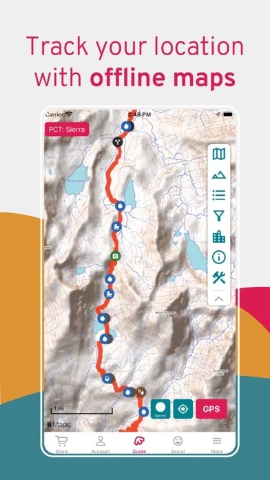
- Works offline: no data or internet required after initial setup

- Detailed waypoints and town resupply guides

- Keep friends and family up to date by checking in and sharing location

- Detailed offline maps including GPS location, detailed routes, and waypoints

- Elevation profile view to see when the next big climb is

- Create custom routes and waypoints to plan trips

- Real-time waypoint comments from other hikers, bikers, and paddlers

- Waypoints include water sources, shelters, campsites, road crossings, trailheads, junctions, viewpoints, peaks, parking, and many others

- Town guides include accommodation, restaurants, resupply, laundry, post offices, shops, historical sites, and more

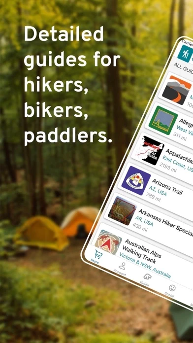
- Covers United States National Scenic Trails, United States Regional Trails, United States Trail Networks, Canada, New Zealand, Australia Hiking, Australia Cycling, UK & Europe, Middle East, and South America.


Overall User Satisfaction Rating


Positive experience
64.3%

Negative experience
35.7%

Neutral
16.8%

~ from Justuseapp.com NLP analysis of 21,006 combined software reviews.

Key Benefits of FarOut Guides

- Useful feature updates

- Most updated and reliable way to navigate on long trails

- User comments provide valuable info for your long hike

- Quick customer support

- Gauge and predict water flow

- Plan out your day with accurate up to date information

- Ability to easily add your own input

- Identify water spots, distances to shelters, and trail highlights


22 FarOut Guides Reviews

4.8 out of 5

By


Lifesaver!

What a difference FarOutGuides makes on a thru hike! Although it does take away a bit of the spontaneous adventure out of a hike, it’s more than necessary for the modern interpretation of a thru hike. Being able to plan out your day with accurate up to date information makes it possible to push all the way until dark and not worry about water or a flat spot to camp. The aspect of a community is also great with the ability to easily add your own input and look back on what previous generations of hikers had to say. You’ll see some sweet hidden gems along the trail because of this!
I love the concept for the big trails, and I won’t ever attempt a thru hike without something like it. However, I give 4 stars because there is still a lot of room for improvement. Even in the couple years I’ve had FarOutGuides they’ve made some good changes, but it still feels a bit awkward navigating through FarOutGuides on occasion and some features feel a bit lazy. I’m sure as more and more folks start to flood the trails who are used to the constant influence of technology FarOutGuides will feel pressure to change.
Overall it serves the purpose great, and the GPS feature could literally be a life saver. Just don’t get too caught up in the constant updates on mileage.


By


Awesome Waypoint Feature Update

Guthook has been my go-to app for AT hiking since day one!!! I even carry the printed guide as backup for the phone. I opened FarOutGuides for the first time in a while for my next hike and was very pleased to see such a useful feature update in an already amazing app.

The only thing I would ask for is it would be nice to be able to display distances between waypoints with the starting waypoint set to zero.

See, I use routes to plan the section and waypoints to break the section up into daily goals. It would be very useful to surface data on my progress through the day. I know I could create a whole new route for each day of the hike but this makes it more difficult to see the big picture of overall progress. It would be great to see the overall section broken down into easy to view daily goals in a similar way as the full route. Kinda like, mini or, sub-routes.


By


Tried and Trusted

I hiked the PCT in 2018 and the TRT in 2019 using Far Out Guides (Guthook back then) and it is by-far the most updated and reliable way to navigate on long trails. Anything from water reports to what towns to resupply in, all the info you need is here. Part of FarOutGuides staying updated to due to the user comments, which have proved to be an excellent source of updates and valuable info for your long hike. The information provided by users not only keeps you informed, but also helps users in the future and gives a snapshot of what changes from year-to-year on a trail.
I also want to highlight the customer support teams quick reply’s and clear instructions. I had a problem downloading a previous purchase from a few years ago and was able to get quick support to get access to that trail again.


By


Must have! + great customer service

There’s just a lot to say about this brilliant app. I don’t even know where to begin. It’s proven itself so useful that it’s become indispensable. When you’re out there, you need FarOutGuides, it is a must have. 👍🏼👍🏼👍🏼

There also isn’t much I can say that hasn’t already been said. My favorite thing about it is that you can literally gauge and predict (per your own judgement and risk) water flow, by reading comments left by people who are ahead of you. My least favorite thing is reading comments left by people who had bad experiences and it scares me 😩😆

User interface could use some improvement. Though it’s already improved quite a bit since I used it in 2019. Not bad where it’s at now. Shout out to team to keep up the good work 💪🏼 I needed some help today and their customer service is just 👌🏼🥰


By


Best App for Southern Sierra and JMT

I really was glad I had FarOutGuides for my 15 day PCT/JMT hike. Our itinerary had our campsites located by mile number on the PCT. This was very easy to find on FarOutGuides . I initially had some difficulty downloading FarOutGuides . Tyler Lau, Atlas Guides customer service, helped me. Then while I was on the trip I had trouble with some of the functions. On my one zero day with Internet access, Tyler Lau helped me again, responding quickly to my request knowing that I was going back on the trail. Evidently there was an IOS glitch that has now been fixed. I used FarOutGuides everyday to find our campsite, water sources & just to make sure I was on the correct route. I also used it exiting over Kearsarge Pass. I highly recommend FarOutGuides. And, most importantly, it has the BEST customer service & help. Thank you!


By


AT Thru-Hike (2015)

I thru-hiked the AT in 2015 which turned out to be the most amazing experience of my life and I did it with the Guthook App. I cannot recommend it enough for anyone planning to thru, section, or simply car camp the Appalachian trail. In my opinion, this goes on the list of "Don't leave home without it."

The AT, at least when I hiked it, was 2,189.2 miles from Springer to Katahdin. Frankly, if you get lost on the AT, you probably don't belong there. So the value of the Guthook App isn't navigation. The reasons I found it to be most useful was to alert me to the elevation that was ahead, distance to shelters and water sources, and road crossings that would take me into trail towns to resupply.

I used the Guthook App daily, but I also took along the AWOL AT Guide. I used this to a lesser extent, but I found it equally important. The AWOL guide is an invaluable resource for services along the trail (e.g., shuttles) and in trail towns (e.g., Post Office hours, lodging, etc.)

I hope this helps and best wishes on your hike.

"Today I begin a new trail in my life. A fresh start. A new beginning. Today I step off the rock at Springer to be transformed because I trust that it is only impossible dreams of this magnitude that will give birth to the type of change I covet." (April 1, 2015)

Tabasco


By


Guthooks saved me from the Bears!!

I’ve loved FarOutGuides for years. Download FarOutGuides , buy your favorite trails maps and keep them forever! Their customer service is truly excellent!

Guthooks is easy to use and has incredible amounts of truly valuable information for the hiker and backpacker. Mileage, elevation, distance between waypoints like water sources and campsites all help in planning my trip.

One source of information that surprised me with its tremendous value was the user comments. While planning a recent trip, I had a choice of campsites, and while reading the user comments on each, I found multiple comments from the week before regarding the high level of aggressive Bear activity around one. So I chose the other and slept well!


By


Valuable instrument

Guthook proved to be a very valuable application on the long trail in Vermont. It is particularly useful in identifying water spots, distances to shelters, and trail highlights such as overlooks. It was also useful four identify your position on the trail, although here is its weakest point. Your location on the trail is only approximate, so that if the trail is not blazed well Guthook can at best only approximate where are you are in relation to the trail. If you are confused, then, it is up to you to put down your pack and walk back-and-forth until once again you can find the trail. This happened to me twice on my last 2-day hike, and it was very frustrating. I understand it is a function of the relative lack of precision of the GPS signal. I also understand that I would’ve been a lot worse off had I not had Guthook!


By


All You Need To Hike The AT

I retired on 31DEC20 and I started hiking the AT on 14FEB21. In preparation for the hike I loaded my phone with Guthook, All Trails and Garmin Earthmate (synch’d to phone). I am two months and 600 miles into the trail. Of the thee apps I have on my phone Guthook far and away is the most helpful. FarOutGuides is so well designed that it is easy to use with very little familiarization. The distances are trail distances and not crow flies distances, the elevation profile view lets you know what will be hard and what will be easy. FarOutGuides shows you all options for shelters, towns, hostels, water sources and much, much more. The customer service is fast and responsive if you have a question. You will never regret buying the Guthook app if you plan to hike the AT.
Snorezilla, 2021 NOBO Thru Hiker


By


Outstanding App

Outstanding is the word for Guthook! The support team is also beyond question, they were exceptional! I started my (eventually failed) thru hike without Guthook. Everyone that I met on the AT—-both thru and section hikers—had FarOutGuides ! During my first “zero” in a hotel with good WiFi, I purchased and downloaded it. Back on trail, it was a night and day difference. It eliminated so much of the mystery that challenges thru hikers initially! Best resupply, water sources, etc. I still carried my AWOL...and used it at night to conserve battery power...but once on Trail, I referred exclusively to “the Hook”! And the value of the interactive comments from other hikers cannot be discounted! This year, I hope to get back on the AT.... I also find the Guthook a great
planning tool.


By


New update is buggy

Been using Guthook the last two years. Amazing app and have faith they will fix the issues. I’m currently finishing my CDT thru and have noticed since the update that it is buggy. Often times my clicks don’t open up waypoints or close the word bubble. I can’t pinpoint the mileage on the red line anymore. You can only know the mileage from waypoints so if someone leaves a comment e.g. “ water cache at 160.4” it can be hard to locate unless there is a nearby waypoint or my gps arrow is close. When in airplane mode you can locate current location in list mode anymore. It just shows a loading circle. I hope these bugs and laggy ness gets fixed before my next long walk.

There is nothing like FarOutGuides and I love it. Maybe my problems are just me being oldschool and resisting change.


By


Must have thru-hikers’ tool

Fantastic app that really helps plan your hike, on and off trail! Where’s my next water source? How far until the next campsites, town, etc? Waypoint comments left by hikers ahead of you on trail are key. And you can create your own waypoints and private notes. Fantastic customer service! I encountered a small bug and notified support. They followed up with me quickly. Unfortunately, the issue couldn’t be corrected right away, but it was addressed in the following software update a few weeks later and they reached out to me to make sure I was aware that they had corrected my issue. I was shocked! Highly recommend!


By


Five stars when....

When Guthook follows the footsteps of GAIA and WorkOutDoors and interfaces with Apple Watch I will give you five stars. I currently pull my iPhone out of a waterproof bag and check my location and directions when at a questionable fork in the road or on a primitive trail. But it would be fantastic to roll my wrist and see a customizable display that I could see current location on a map, time, speed, altitude and distance to destination on a dashboard. Then be able to slide to the left or down to see more customizable displays. Also what do I have to do to add photo to the trail. It would be sweet if we could add a picture of the bridge being out, or dogs attacking to warn our fellow hikers. There may be a way but it hasn’t worked for me.


By


Hiking the AZT

Before Guthook had developed the AZT trail guide, my husband and I were section hiking it. There were many times we would come to unmarked areas where the trail might head off in various directions or be overgrown and vague. We would inevitably head the wrong direction, note within a mile or so no signage, get out a map and try to figure out where we went wrong. Obviously this led to much backtracking and grumbling. Now I simply pull out my phone at a questionable spot, open the Guthook map, walk ten or so feet one direction or other and visually see my Guthook marker moving on or away from the trail. It is a lifesaver in many ways! Thanks Guthook crew for making life on the trail a great adventure without the grumbling!


By


AT Section Hike Essential

Using FarOutGuides exclusively, I’ve now section hiked three states on the Appalachian trail. During planning, it’s helped me visualize every single day - down to the minute, mileage, elevation and water stop. When I’ve gone off-trail, it’s pointed me in the right direction, and when I’m tired it’s been my motivation, knowing exactly how many miles there are to the next waypoint. It’s also kept me safe because I know exactly where water, shelter, and towns are, and it’s reliable as ever. I even had momentary issues with FarOutGuides , and the creator himself was writing me, making updates, and genuinely wanted to help. I carry a back-up map of course, but FarOutGuides is truly all you need to get out and hike.


By


Great Asset on the Trail

I'm a former troglodyte and a late adopter of technology. I've loved maps since I was a child, and I know how to read a map and use a compass. (I spent a dozen years in the Coast Guard and half of my career was at sea. I was a Quartermaster - I really know how to navigate with a map.) But I rode to the trailhead in a horseless carriage, and I'm carrying a pack made from nylon, not cotton. Rejecting technology on principle is silly.

I'm using FarOutGuides to hike sections of the PCT in Washington as time allows. FarOutGuides is awesome! I love the ability to look at the elevation profile between two points along the trail. That makes planning my day's route much simpler. I also love the comments. It's nice to know that someone passing a seasonal spring two days ago was able to get water if that's a spring I'm hoping to get water from myself, and it's nice reading about where there are good hammock sites.

I have another app on my phone that allows me to download the USGS 7.5 maps. The two together are an excellent combination.

Why four stars instead of five? If FarOutGuides showed the topo lines in the background and let me "flip flop" it so it's set up for southbound travel, I'd give it five stars.


By


Tyler Lau is the bomb!

I have happily used Guthook guides for about 6 years but had never logged into account on my phone as I always got an error message. With a 500 mile sobo coming up next week I wanted to be able to post comments but needed to log in to do so (was using the old app?) Anyway I got Tyler as my support last night and then following through this morning. He was so patient, thorough and gave systematic and explicit directions, trying all possibilities to solve the issues with not one but two devices. I as a not so savvy tech person needed and SO appreciated his help and perseverance. He should get a raise and be celebrated.


By


Great app but still room for improvement

Let me start by saying FarOutGuides will get you through the entire AT without trouble. The only thing I would change would be to add the ability to create custom waypoints to save on your adventure. This is mostly because there were lots of camping and water supplies we came across that were not listed that will could be hard to find again when trying to go back and visit favorite spots on the trail. Another instance I could see it helping would be when you come across areas that are reroutes around bridge washouts or Bees nests. Even without this ability, this is still very much worth the cost of the maps.


By


Modern hiker must

Guthook is the most popular trail navigate app on the Appalachian Trail, as far as I can see. It works well for knowing shelter, campsite, water supply, wayside, view, and road locations. The public comment section of these locations keeps hikers updated on conditions, including water availability, bear sightings, trail conditions, etc. If one deviates from the trail, Guthook quickly shows where the mistake was made and how to get back on the trail. Since Guthook can be run in Airplane Mode, battery usage is optimized. My brother and I alternated days running it on our phones, which further helped with battery use efficiency. Overall I recommend using Guthook.


By


Works great

Guthook was recommended by so many legitimate hikers that I wasn’t too worried about the functional side of it. I was concerned that it might be more than I need or want which it definitely is. (But not in a bad way) I don’t need to post or check in. I have low vision and can no longer count on my vision to navigate correctly. Since a compass and map don’t work well for me anymore I bought and downloaded the Maine trails and it works like a champ. Having an accurate GPS location and with the mileage is awesome.
I imagine sighted people could use FarOutGuides too. Lol


By


Developer has lost focus

FarOutGuides was written to support backcountry hikers going long distances with minimal contact with internet. The current developer seems focused on a money grab of section hikers. Updates to FarOutGuides break more than they fix (and we’re talking basic stuff like crashes and inability to look at adjacent waypoints). This ignores the obvious API misuse of basic features (CoreLocation use is wrong: blue bar should not show on exit; MapKit use is wrong: app should indicate its drawing an opaque base tile rather than asking Apple to download its own map only to be covered up).

Worse, the developer takes money for trails like the Te Araroa and doesn’t even bother to incorporate the freely available data in a way that’s actually navigable. As an example, the Trust notes (the basis for the trail) describe how to make it from on side of Rakaia River to the other. The gpx, however, does not include this because it’s not official. This, in turn, means Guthook/Atlas does not include a continuous footpath. FarOutGuides is so stingy about providing base map data that there isn’t even enough detail to find it on your own, forcing you to use a third source of info (the Trust maps).

It might very well be worth your money to buy a trail because when it does work it’s quite convenient, but FarOutGuides quality is in a downward spiral.


By


Seems to be missing a lot of info that is contained in other guides

After using this for a while on the AT, it’s become apparent that there is a lot of data out there on the trails and towns that is not contained in FarOutGuides. I’m not sure where FarOutGuides pulls data from, but it’s lacking in that department. Other guides seem to list more, and more current, data about available resources, like hostiles, restaurants, stores, etc. on the trail. And while the maps are nice, there are important waypoints that are just not listed. However they exist in other guides.

FarOutGuides itself seems to run fine for the most part. I seem to experience an issue where the GPS stays enabled even though I turn it off in FarOutGuides . FarOutGuides shows the GPS off, but as soon as I move to the home screen (app in background) the little blue bubble in the upper left corner continues to indicate enabled. The only way to get it to stop is to force close FarOutGuides .


By


Guthook Pinhoti Trail app

Ryan and all at Atlas Guides,
Folks had been daily asking me for a map of our trail complex here on Flagg Mountain. Flagg is the southern terminus of the Pinhoti Trail, the beginning of the Appalachian Mountain Range, a very popular place for day hikers and backpackers here in Alabama.
As a member of the Alabama Hiking Trail Society, I serve as the official caretaker here for the Alabama Forestry Commission. Until your app became available, I had no way of helping folks hike the mountain. But that's all changed now, thanks to the Guthook Atlas Guides Pinhoti Trail app! Folks can quickly review our loop trails, choose how they'd like to spend a few hours--or a weekend. You've literally put us on the map, Ryan; thanks!


By


Appalachian Trail

Used the Guthook app while hiking the AT in 2017 and was extremely satisfied with it. Everything in one easy to use accessible package, worked well on my iPhone. The people at Guthook continued to update and improve on FarOutGuides as I used it. Bugs were addressed and fixed quickly, waypoints, resupply, water sources were at the location FarOutGuides said they would be. Would recommend, and have recommended FarOutGuides to anyone thinking about hiking or section hiking the AT. My satisfaction and trust in the people at Guthook has me returning for an app to take on the Arizona Trail and I hope an app for the PNT is released very soon.

NNoHurry


By


Developers lack of response

The developer seems too only respond to the positive reviews.... waiting for their response from Tim on Dec 22nd. If you read a few reviews you’ll notice quickly that the developer for the most part simply ignores the critical reviews that point out quite explicit where FarOutGuides needs updating, fixing and more developer attention. It seems obvious that their placing all their attention on simply selling maps instead of offering a quality product. Save your money for now until the developer gets their act together. There’s many other more worth while places to purchase than here. Ralph, New Jersey


By


Greatest hiking app ever

Can’t say enough good about FarOutGuides, it lets you know where you are, pending elevation and how far you are from that shelter or campsite you’ve been hiking to all day. Has every thing a hiker needs to know at fingertip, shelters, hostels, water, road crossings ( where you can schedule a shuttle to come get you and take you to the hostel or town). I love FarOutGuides, it’s such a psychological boost to know how close or even far you are from your destination . It works on airplane mode so your phone isn’t drained and new trails are added all the time. Highly recommend FarOutGuides for any hiker!


Tred mcintire   1 year ago


Impossible to set up user account. Should be intuitive. Says my suggested user names have been taken by my email. Never had such a hard time with an app.

Mark Flint   2 years ago


Very frustrated with my Arizona Trail map. It has no comments on a segment I plan to hike this weekend, and there were plenty when I hiked the same segment in March. The FAQ help is useless. It says to go to the download manager and select Force Download. Dead end. There is no Force Download on the download manager.


Is FarOut Guides Safe?


Yes. FarOut Guides is very safe to use. This is based on our NLP (Natural language processing) analysis of over 21,006 User Reviews sourced from the Appstore and the appstore cumulative rating of 4.8/5 . Justuseapp Safety Score for FarOut Guides Is 64.3/100.


Is FarOut Guides Legit?


Yes. FarOut Guides is a totally legit app. This conclusion was arrived at by running over 21,006 FarOut Guides User Reviews through our NLP machine learning process to determine if users believe the app is legitimate or not. Based on this, Justuseapp Legitimacy Score for FarOut Guides Is 81.1/100..


Is FarOut Guides not working?


FarOut Guides works most of the time. If it is not working for you, we recommend you excersise some patience and retry later or Contact Support.


How was your experience with FarOut Guides? Post a Review

Leave a comment:


Alternatives