Paddle Ways - Lets Go Paddling Reviews

Paddle Ways - Lets Go Paddling Reviews

Published by on 2024-04-21

About: The #1 resource for the Paddling & Rafting community. Get river maps,
conditions, rapids intel, and more while sharing important river and lake
information with the PaddleWays community.


About Paddle Ways


Upgrade your experience with a PaddleWays Plus subscription, offering access to premium features, including offline maps, river guidebooks, real-time flow data, and public & private land data.

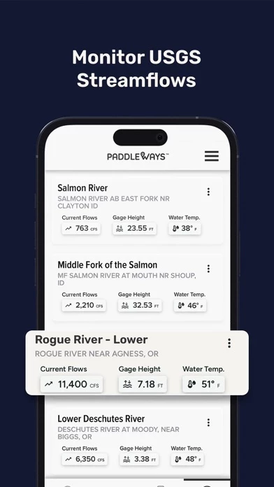
Save your favorite river sections, check real-time weather conditions, and monitor river flow rates (CFS) by location to identify the ideal time for your water float trips.

Get river maps, conditions, rapids intel, and more while sharing important river and lake information with the PaddleWays community.

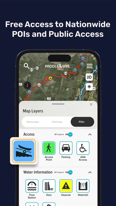
Choose from Satellite, Outdoor, and Street map modes, measure distances in river miles, and set location-based alerts for upcoming take-outs, campsites, or rapids.

Discover a variety of river sections, as well as rivers and lakes, both nearby and farther afield, with our interactive maps.

Developed in collaboration with American White Water, this app provides vital information to ensure safe and informed decisions before your water float trips.

Calculate river miles, access thousands of points of interest, such as access points, boat ramps, campsites, and more.

PaddleWays serves as your indispensable digital guidebook and GPS navigation tool for your paddling adventures.

Utilizing technology developed by onWater, PaddleWays donates 1% of sales to promote responsible use and resource conservation.

Whether you're into kayaking, rafting, canoeing, or stand-up paddling, PaddleWays has got you covered.

PaddleWays is more than just an app; it's an interactive atlas and community forum created for paddlers, by paddlers.

PaddleWays is powered by NRS, committed to making human-powered recreation more accessible, safe, sustainable, and enjoyable.

Stay informed through user comments on recent conditions and reference notes, photos, and saved locations from your previous trips.

Delve into guidebook descriptions, assess your skill level with provided difficulty ratings, and access related resources for comprehensive insights.


Overall User Satisfaction Rating


Negative experience
65.6%

Positive experience
34.4%

Neutral
22.7%

~ from Justuseapp.com NLP analysis of 59 combined software reviews.

160 Paddle Ways Reviews

3.6 out of 5

By


Excited to see where this goes

Hopping into the beta test for this - so if you’re reading this review in the future and I haven’t updated it yet, keep that in mind.

I have high hopes for PaddleWays! Maybe it’ll be like alltrails for paddling.

Things I think need some work currently:
Needs more content. Only one route near me, but I know of so many more.

The boat launch drop in/out locations should have addresses and an info page for parking, restroom access (if any), fees, photos.

I’d love to see the ability for users to create their own routes.

Lakes should be listed too, with boat ramp info. I SUP a lot on local lakes.

It’s strange to me that there isn’t much of a navigation bar - I haven’t paddled yet but I would hope that PaddleWays will be able to record my route, and save that in a log. It would be awesome if it had some functionality similar to Strava for cyclists where you have your own profile and can follow others, share your routes etc.

Another neat feature would be something similar to Waze where users could mark hazards on the route or create comments for others like “if the water is low stay left here”

Pros so far:
PaddleWays is smooth. No ads are a big plus.
The map is beautifully done.
I like the list view option (but it should tell me how far the route is from my current location too)
This is an awesome concept that paddlers have needed for far too long!


By


Maps ok database needs work

The maps look good and points of interest appear accurate (MapBox) but the trips database is weak. For example the Lower Deschutes is described as one trip of 110 miles. It is actually a day trip and two overnights with a mandatory exit at Sheers Fall. I noticed several other similar issues in other rivers. Some of the data appears to be from the AWA. They should get more data from similar sources.

The free trial may be crippled too much to properly review but not enough there to justify going for a year subscription even with the 50% discount at this point.


By


Looks and feels good

I was really surprised to see just how few rivers are listed in the database. I understand this must be a massive undertaking adding rivers and all the info. My biggest suggestion would be to allow route creation similar to Strava. In that app, which is a similar price point for yearly subscription, it’s very easy to create routes on any river in manual mode. Obviously this app will(or should) have to make their own user interface for this kind of feature. Given that there’s so many bodies of water it only makes sense to allow info creation from users. I’m in TN and REALLY surprised to see the pigeon on the map but not the Ocoee? I’m interested to see how the developers move forward with PaddleWays, but I believe most users are going to struggle to see the value in subscription unless something can happen quickly. I’m also not sure how this service can be better than using AW. Just my thoughts, would love to see where it goes!


By


Hard to tell

It might be a great app, looks like it would be, but I couldn’t really tell. There is supposedly a free 14-day trial to test it out, but every time I tried to access any of the features it threw up an upgrade-to-premium payment screen. I went ahead and payed because I was sure I wanted the features, got an email confirming my subscription and receipt of payment, but it still persists in displaying that annoying upgrade pop-up when I try to access the features. Hence it might be great, but I can’t tell since I still can’t get into anything. I gave it three days to allow time for payment processing, updating status, or whatever might need to happen in that line, but after that when nothing changed I canceled my subscription. No point paying for an app that refuses to be used.


By


Killer App! Love it!

PaddleWays was literally so helpful on our last five day river trip! The GPS location works the whole way, and really helped us figure out stopping points, great beaches, and helped us better time manage our trip! I can’t wait to see them expand into more rivers throughout. it’s definitely worth the small fee per year! Very few complaints for such a new app!

I would like to see a check-in point at different beaches, so people will know what beaches are taken. It also needs to be fine tuned in accordance to the BLM and forest service maps.


By


Keep it up!

I love what PaddleWays has going so far…maybe they could have saved themselves some of the more mean-spirited reviews by putting BETA in all caps all over. For the info so far it’s a great way to navigate to see different river conditions. Easier than the web browser pages many rely on. I hope this can become a one-stop shop for gauge, CFS, put-in/take-out, parking, restrooms, fees, so we’re not jumping around different apps and sites to plan trips. Meanwhile I appreciate that the named rapids in the Lehigh are marked!


By


Offline Maps Useless

The best part of PaddleWays would be the offline maps - however if you zoom in enough to actually differentiate between the points of interest (camps, rapids, etc) in an offline map, the points of interest disappear. Could be a great useful tool… eventually. Also, would be nice if I could download specific sections of rivers. I don’t need to download the entire Salmon River (ID) if I’m only boating on the Lower Salmon section.


By


Has potential

Unless paying PaddleWays doesn’t let you see much, currently it’s not worth it to pay for the subscription but that may change as it receives updates.


By


App is even dangerous

No flow info or flow level guidance which is absolutely essential for safety when encouraging river access. Descriptions of rapids I know on the South Fork American are either wrong or incomplete, and a few descriptions provide dangerous advice (Troublemaker (“swim to either side”) and Second Threat (“fun to swim”). A quality company like NRS should not be in the chain of liability for something as incomplete and erroneous as PaddleWays. Thankfully, there are plenty of free web sites with far better information on access, safe flows and the runnable lines.


By


Stoked to see where this goes!

I’ve been looking for an app that makes getting on the water easier. I’m stuck in a rut of going to the same place to paddle over and over again.


By


Great Job!

These people are doing a really great job with PaddleWays so far. I'm just starting out rafting and I really appreciate all the super useful information I've gotten so far. Thanks for the good work! Totally worth the cost.


By


Beautiful but still very Beta

At the top of my “needs” list for a Whitewater reference app is quick access to Flow data. PaddleWays currently has no flow data.
It’s super sexy and pretty until shows you it’s toothless smile.
With NRS involved I expect the content to improve. I’ll definitely be checking back but for now there are several superior solutions for traveling whitewater boaters.


By


Love the vision!!

This is an ambitious undertaking and will be AWESOME once y’all get it all fully filled out! Y’all keep up the good work and don’t let the negative reviews, while it’s all still in beta, get ya down…keep pushing! 🙌🏼


By


Has Potential

I think this has potential; but there are significant gaps in the river data. How are rivers added? How can users submit real time beta? From southern Idaho, popular runs are missing. Payette: Cabarton, Canyon, Swirly Canyon. Boise River: No data

I think the price point is reasonable if the data is there. At this time, I cannot renew after the trial ends.


By


Needs more value

Format is not very intuitive and favorites list makes you go a long way to find flows. They should bring flow data directly to the favorites list. Common runs in my area are not yet included. Detail provided for runs is minimal. Rapids data is canned and not specific. Not ready for $2/month and certainly not $9/month. Unfortunately.


By


Has promise, but needs work

I agree with a lot of the comments about the need for more rivers,etc.

My constructive criticism is that while the interface looks good on my iPhone, it is almost unusable on my iPad. I have the large screen pro with tons of memory and the latest iOS. It looks like a blown up phone screen but half the words are only visible. While I’m excited to use it ob my phone, I’d prefer to do any trip planning on the larger screen of the iPad. I cannot talk to whether this is an issue on any other platform (android, etc.)


By


No useful value

The promise in PaddleWays Store is that PaddleWays is great for all paddle sports, but unless you are interested in white water in a select few states it is COMPLETELY USELESS. In a state with literally thousands of routes and several water trails available for multi day trips they list 5 short whitewater spots that you can find on Waze


By


Has Potential

PaddleWays has potential, but it is useless if you live in the middle of the country. I live in Memphis, and it doesn’t have *any* of the rivers I searched for within five hours of me. Not even the Mississippi! Looks like it’s made for folks who live in the Pacific NW or New England.


By


Not good

I got a ad in a recent NRS purchase, was excited. Once I got into it, it has very little data or rivers for Ohio, and surrounding areas. Rendered it useless for me. It’s basically just a simple mapbox app, nothing special.


By


Check back in later

Very few rivers in my region included and no flow data.


By


A great app but I wish they would be honest

They keep throwing free at you in all the adds and not until you download do you find out they only tease with a little free info and you need to pay to get anything substantial. That said it’s worth the cost I just don’t like dealing with people that work that way.


By


Ok App, not enough features / information

Free app is very limited. It's a crowd sourced, yet paid app. If it had more features in free app I might use it. No incentive to provide information like free month after a few edits. Probably keep using other app and other online resources.


By


Cool, but limited

PaddleWays is really cool and has a lot of information but I didn’t like that I couldn’t sort what I was looking at. I paddle board with my kids, and most of the information I found was more for kayak or raft/rapids etc. I’d love to be able to see what’s around me that would be gentle enough for relaxing on my board and paddling with my family. PaddleWays ad specifically mentioned paddle boarding so I expected that kind of thing to be easier to find. Really cool app otherwise though with maps that are easy to explore in general terms with good information for people ready for something more advanced/adventurous than what I’m looking for.


By


Love the app

My go to for kayaking in Florida


By


Awesome resource for new paddlers!

PaddleWays is a must have for people looking for their local drop in and the general info about it.
I’m new to kayaking and joined a group to find areas where I could legally go and what the general info was for that spot.
PaddleWays was recommended to me and makes it easy to pick new spots and find places that I would have never knew about.
Worth downloading and having on hand to reference!


By


Has potential but needs some work

PaddleWays is intuitive and visually appealing but lacks helpful content even in the membership version. There are claims about gaining more info on river details yet I only ever get the river distance in its entirety and nothing more besides a few major rivers in my state. Also when you create a route, the lines are wildly inaccurate. That being said, the gauge location/information and general map of rivers is nice to have and it is convenient to be able to save certain river gauges to keep an eye on levels.

Suggestion: More river info (a lot more), allow local users to suggest/report boat launches on the map, create more accurate snap-to mapping, allow commenting so local users can share updates and info, incorporate a list of what is runnable like AW has, add important features like dams to the map.

I look forward to the developers working out the kinks because someday this will be a fantastic app.


By


Class V power at your fingertips

PaddleWays is bomber. The tools, insight and information it provides in the easy to use platform it’s designed with is an incredible addition to the quiver of tools for any boater. Whether it’s beta on a rapid, checking the flows of my favorite runs, or finding put ins and take outs for new runs.. and even a scat machine along the way.. PaddleWays makes it easier and more enjoyable than ever. One of the few sources for an increase in screen time that I’m stoked for. Highly recommend for anybody and everybody who’s looking to spend time on the water.


By


Love this app for planning logistics

I really like that you can click on an icon and have a description of the feature. It doesn’t take away the need for scouting, but it does give you the opportunity to have beta and a visual. I’m also a fan of the boat ramps and other access points for flat water, it’s really made my paddling more enjoyable as I’m exploring more water in the area that I had otherwise not even considered. The map really emphasizes every body and makes it easier and more fun to plan the next trip.


By


No advantage over maps

I hate apps that don’t even give you a preview without inputting all your info, but as I wanted more water info, I gave it a shot. Got nothing. Shows the nearest boat ramps, but doesn’t say if they are paid or free. No parking information. No ramp construction details. Nothing. Obviously most of these apps are crowd sourced, but this one is taking from a shallow pool. Tried a well known lake in the nearest capital city, thinking more people might be logging there, and got no more extra info than who maintains the dock. Worthless for me. Using a search engine results or satellite maps and you get the same amount of info.


By


Resourceful

Definitely a great app for those who need the information to enjoy the water ways near them.

But also great for adventurers, with a community made map you can find places that are not charted on PaddleWays and contribute for the next water junkie to take advantage of.

Overall great app


By


Great app with a lot of potential

Seems like a great all-around app. Have used to find some local places to put in that I don't know about! I just wish there were a few more free features. I don't get to get on the water enough to justify a subscription. Even tho it's not really a lot. Might try premium one day if I find
more paddle time.


By


Only Detailed Paddle App on App Store

In my brief search for an app that would give me all the available routes to Canoe or kayak on, this app stands out as really the only option. The maps are beautiful satellite imagery, with suggested route planning. I wish PaddleWays was more adopted by the paddle communities at large so that it could have more comments on the route planning.


By


Good Start

There’s a lot of potential in PaddleWays and it’s got a good foundation. But there are also a lot of features that I would expect that are just missing, such as information about lakes, launch point fees, and more detailed descriptions of sections of water. And the constant encouragement to upgrade to a paid version isn’t very appealing, particularly when there are more currently useful and informational free paddling apps.


By


Too expensive for too little data

Having spent quite a bit of money with NRS, I would think they would give me PaddleWays for free for more than 7 days!! After checking it out I feel like my local water trails app has much more details and for far less expense. The idea of being able to map my trips, get detailed info on flow and/or tides, driving directions, parking passes needed, facilities, camping spots etc is what I’m looking for.


By


Good tool, would be great as more sources get added

Overall this is a great tool for planning and to get beta on sections of rivers with recent trips. Some of the river gauges and river names are a bit hard to search (Gates of Lodore doesn’t show up when you search). Other than that, great app.


By


Loving this App

I’m loving PaddleWays . I’m liking the ability to measure distance easily and mark our river island campsites, as well as saving my favorite local rivers to monitor CFS (especially now during runoff). I think as time goes on and more people use it it will be awesome to report current hazard and beta.


Is Paddle Ways Safe?


Yes. Paddle Ways - Lets Go Paddling is quiet safe to use but use with caution. This is based on our NLP (Natural language processing) analysis of over 59 User Reviews sourced from the Appstore and the appstore cumulative rating of 3.6/5 . Justuseapp Safety Score for Paddle Ways Is 34.4/100.


Is Paddle Ways Legit?


Yes. Paddle Ways - Lets Go Paddling is legit, but not 100% legit to us. This conclusion was arrived at by running over 59 Paddle Ways - Lets Go Paddling User Reviews through our NLP machine learning process to determine if users believe the app is legitimate or not. Based on this, Justuseapp Legitimacy Score for Paddle Ways Is 57.1/100..


Is Paddle Ways - Lets Go Paddling not working?


Paddle Ways - Lets Go Paddling works most of the time. If it is not working for you, we recommend you excersise some patience and retry later or Contact Support.


How was your experience with Paddle Ways - Lets Go Paddling? Post a Review

Leave a comment:


Alternatives