Great Depths Reviews
Published by Walk About Apps on 2017-09-28🏷️ About: Turn your iOS device into a digital depth finder. Great Depths offers coverage of the entire US coast, the Great Lakes, Lake Champlain and more.

🏷️ About: Turn your iOS device into a digital depth finder. Great Depths offers coverage of the entire US coast, the Great Lakes, Lake Champlain and more.


We Investigate the app owner's website (Walkaboutapps.wix.com), verify their legitimacy, and uncover hidden scams and complaints.
Doesn't show any depths until you buy more lakes. Only certain lakes are purchasable
Waste of money
GreatDepths is absolutely worthless. Please save your money. Nothing works and every map cost additional money Lake Erie for instance has four different map locations that each cost separate money from your initial cost. I hope someone produces something better.
But on an iPad and 6+ GreatDepths locks up and will not function. Trying to expand to a point where you can actually READ the charts of Lake Champlain and the Hudson canal produce more lockup. App is nonfunctional for me and two emails to the support contact produced NO response-which was the largest disappointment. I doubt a refund is to be offered, but one is certainly in order!
Works better than the one stock on my 2007 21 foot wellcraft!
Need to flag protected areas so this can be used for on water navigation
36° 33.650' N. lat. 121° 57.600' W. long.;
36° 33.650' N. lat. 121° 58.500' W. long.;
36° 33.100' N. lat. 121° 58.500' W. long.;
36° 33.100' N. lat. 121° 57.600' W. long.; and 36° 33.650' N. lat. 121° 57.600' W. long.
Be able to enter coords like this so that it will show the boundaries of that protected fishing area
Very, very cool. Crashes are common and slow to load. Other than its actually quite awesome.
I asked for a demo before I bought it and they responded in 2 days with free demos. Great customer support
Of what I've used... it works great.. looking for nav. aids as direction and distance
We were visiting Lake Champlain for the week and had a paper chart but our chart plotter didn't cover this area. Got GreatDepths while exploring the lake and it was a tremendous help when cruising along!
Solid. The charts and digital depth readings are great. Perfect for cruising around Lake Champlain.
The map always automatically loads to a picture map. It is very irritating and I would love to just keep the satellite map on while I browse the ocean depths. Is there any way to just keep the satellite map on without it automatically switching?
Perfect for day trips on the bay. The tide predictions are really nice. A+ app.
Great app with many great features, simple intuitive to use. Keep up the excellent work.
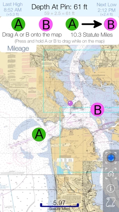
I'm using GreatDepths on Lake Champlain where it's a great replacement for a stand-alone GPS. Your position is shown on the actual scanned-in lake charts which have the depth markers (it's not an actual depth finder).
If you have an iPhone and a boat, this is for you.
Great ap. had issues at first. Product support was great resolved all issues. Overlay maps add great detail!
Great Depths is very safe to use.
JustUseApp Safety Score for Great Depths is 66.6/100.
This assessment is based on our NLP analysis of 12 user reviews.
Combined with the app store average rating of 4.2/5.
Great Depths looks authentic and legitimate.
Our NLP models processed user feedback to estimate legitimacy. JustUseApp Legitimacy Score for Great Depths is 66.6/100 .
This conclusion is based on analysis of 12 user reviews.
**Pricing data is based on average subscription prices reported by Justuseapp.com users..
| Pricing Plans | Amount (USD) |
|---|---|
| All the Charts | $0.00 |
| Connecticut and New York Coast | $0.00 |
| The Chesapeake Bay | $0.00 |
| Midwest Florida Coast | $0.00 |
| Southeast Florida Coast | $0.00 |
| Lake Champlain | $0.99 |
| Southwest Florida Coast | $0.00 |
| Huge East Coast Charts | $0.00 |
| Maine, New Hampshire and Northern Mass. | $0.00 |
| Lake Michigan | $0.00 |
Chart coverage includes the entire coast of the contiguous USA, the Great Lakes, Lake Champlain, the Erie, Oswego and Champlain Canals, Lake Mead, Lake Oswego, Lake Pend Oreille, Lake Okeechobee, Lake Winnebago, Franklin D.
Great Depths offers coverage of the entire US coast, the Great Lakes, Lake Champlain and more... Know exactly where you are on the water and cruise to your port of call directly and safely.
Great Depths offers digital depth readouts, live tide data and NOAA RNC nautical charts in 60 bargain-priced packages.
-- Best of all, Great Depths is FREE and never has adds! You can download the app and preview the available charts packages without spending a dime.
Digital depth readouts are automatically adjusted based on current tide/lake level and are updated as you move or viewed anywhere with the touch of a finger.