Terrain Radar Altimeter Reviews

Terrain Radar Altimeter Reviews

Published by on 2024-01-08

🏷️ About: Measure the elevation of each location within a radius of 500 meter. With Terrain Radar Altimeter you can discover the height of hills in front of you or take a look at further away mountains.


Overall Customer Experience 😎


😎 Positive experience
48.8%

🀬 Negative experience
35.4%

πŸ«₯ Neutral
15.8%

~ from Justuseapp.com NLP analysis of 653 combined software reviews.


Summary of Customer Reviews (Takeaways): πŸ’Ž

- Accurate elevation readings

- Useful for outdoor activities such as hiking, hunting, and motorcycle riding

- Provides a simple plot of terrain ahead

- Easy to use with a simple yet complete user interface

- Reliable and informative


Read 20 Customer Service Reviews πŸ˜ πŸ’’

4.7 out of 5
Discussed

I’m in the woods and want to know what elevation it is. It says no internet. Yes you idiots I know the elevation where I live. I want the elevation of the mountain I happen to be on.

Scoutmaster

Very limited view. To increase distance have to buy another app.

Decent but altitude reads incorrectly.

I am at 856' ASL but app shows I am 897'. Wish I could change take it out of satellite mode.

Kich2000

I find TerrainRadarAltimeter very useful and use it often. However, I don't understand why, most of the time, it points 180 degrees away from the actual direction of my phone ?

Almost great, BUT.

Would I buy TerrainRadarAltimeter again ... probably. Because it has what may be a distinct feature in it: you point your iPhone in any direction and it shows satellite view of what’s ahead (up to 17k feet with $1.99 upgrade).
BUT it has two missing things to wish for:
= You can’t zoom in close enough to clearly recognize things. There is an intersection about 500 ft from my house and I could not clearly identify it.
= There are no road names so its even harder to identify locations you see in the satellite view. It needs a hybrid view.
If the developer added these two abilities my opinion of TerrainRadarAltimeter would go from OK to Great.

Not bad...

Interesting to use.

Enjoy while Climbing

Have use this application on every climb I've been on in the past six months. Has come in handy several times.

Pilot

Works for me

Awesome!

TerrainRadarAltimeter is wicked. It has so many uses.

Terrain Radar

I enjoy using this application here in Alaska. Whether the function is for motorcycle riding, hunting or simply curious, knowing my elevation and territory in front of me is perty sweet. No frills, nothing excessive, just a simple plot of where and what lies ahead. I would include a bearing in TerrainRadarAltimeter and/or compass heading feature. TerrainRadarAltimeter is a standard function on my iphone. Kudos to the designer. Molon Labe.

Red

dit

Terrain Radar I great!!

I highly recommend TerrainRadarAltimeter if you are outdoorsy and like mountain views and various trails you hike or place you go!!'

Elevation

Above sea level terrain is good on graph.

Mountain Person

Great App. Very reliable and informative.

Useful, simple & fun

I live in a very mountainous city in the Andes, and TerrainRadarAltimeter is incredibly useful, fun and simple to use.

Great app

I us TerrainRadarAltimeter in my walking on the ridges and valleys it gives a accurate reading.

Accurate, useful.

It was exactly what I was looking for as per the description

Simple app that gets the job done.

TerrainRadarAltimeter is incredibly easy to use with no obstructions. It's simple yet does what it advertises. The user interface is simple yet complete. I am definitely going to buy the paid version.

Excellent

This is one of the coolest apps that does exactly what it says. I wish I had it before my last driving trip to the lake in the mountains. It automatically updates terrain ahead when you move the iPhone.

Awesome

TerrainRadarAltimeter is an awesome addition to my topo map/ compass while hiking. Very surprised it has not been rated yet. The measurement at my house is spot-on so I have a degree of confidence in it already. I also like being able to see elevation changes out several hundred to several thousand feet in all directions. Five stars.


Is Terrain Radar Altimeter Safe? πŸ™

Yes. Terrain Radar Altimeter is very safe to use. This is based on our NLP (Natural language processing) analysis of over 653 User Reviews sourced from the Appstore and the appstore cumulative rating of 4.7/5 . Justuseapp Safety Score for Terrain Radar Altimeter Is 57.9/100.

Safety Analysis

81.9% of users say app is Safe πŸ‘
81.9%

14.7% of users have Some Concerns ⚠️
14.7%

3.4% of users say app is Risky 🚨
3.4%


Is Terrain Radar Altimeter Legit? πŸ’―

Yes. Terrain Radar Altimeter is a totally legit app. This conclusion was arrived at by running over 653 Terrain Radar Altimeter User Reviews through our NLP machine learning process to determine if users believe the app is legitimate or not. Based on this, Justuseapp Legitimacy Score for Terrain Radar Altimeter Is 76.6/100..

πŸ” Privacy & Data Safety

Terrain Radar Altimeter collected the following data from you:

  • Data Not Linked to You:
    • Usage Data
    • Diagnostics

Payments πŸ’Έ

**Pricing data is based on average subscription prices reported by Justuseapp.com users..

Pricing Plans Amount (USD)
Long-Range Radar $3.99


How was your experience with Terrain Radar Altimeter? Post a Review


Features

The unique combination of device sensors and internet-based geo informations makes Terrain Radar to the best altimeter app in the store.

With Terrain Radar Altimeter you can discover the height of hills in front of you or take a look at further away mountains.
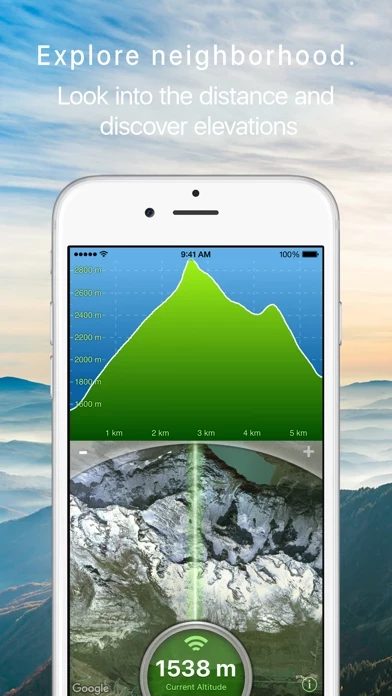
The altitudes are calculated through online services, based on your GPS position and compass direction.

Measure the elevation of each location within a radius of 500 meter.

  Contact Support
Developer:
Nestele Engineering

Contact e-Mail:

Privacy Policy: