Rivercast - Levels & Forecasts Reviews

Rivercast - Levels & Forecasts Reviews

Published by on 2024-10-24

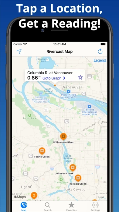
🏷️ About: Rivercast™ is an app that provides river level data through interactive maps and graphs. It offers official flood warnings, river stage height, river flow rate, indications of approaching flood stage, current observations, and NOAA river forecasts. The app has a map interface that shows where river gauges are located geographically, a search interface to find river gauges, and interactive graphs that can be customized by adding relevant river levels. Users can also create a favorites list, share graphs via social media, and monitor their favorite locations through a widget.


Overall Customer Experience 😎


😎👌🔥 Positive experience
43.7%

👿🤬😠 Negative experience
41.5%

🙄💅🫥 Neutral
14.7%

~ from Justuseapp.com NLP analysis of 9,322 combined software reviews.


Summary of Customer Reviews (Takeaways): 💎

- Accurate water level monitoring and forecasting for rivers and gauges

- Useful for professionals in the marine and construction industries

- Helpful for recreational activities such as fishing and hunting

- Map layout and favorites make it quick and easy to use

- Provides data for many gauge stations


Read 23 Customer Service Reviews 👿🤬😡😠💢😤

4.7 out of 5

Waste Of Money

2022-05-23

Paid for premium to see forecasting of river at my cabin knowing a flood was coming. Premium gave me no additional data!!! Pretty bad when another free app included the forecasting data as provided online by the Advanced Hydrolic Prediction Service. Complete waste of $5 for me and a reason why we should be allowed to try apps before buying.

UPDATE: Rivercast developer took two weeks to respond with a lame blanket statement that provided no help. Another River app developer contacted me in days and worked with me via email to identify the issue with the missing data.

Like it but.....

2022-06-24

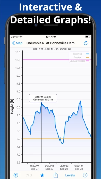
I like Rivercast and seems to work well. The only thing I’ve found that I don’t like is the way the graph works. I don’t like the fact you have to hold your finger on it to view past and future river levels. I end up messing up the graph with some pinch move and can’t tell what the level is then.

Good app, where are push notifications via text?

2022-07-25

Good app, however would like to see more notifications pushed to my phone or email giving me updates on favorite river water levels.

Mehhh

2022-08-26

I had a great river app that let me store many favorites and was extremely valuable to me. I did not have to pay anything for it and after a few years Rivercast was no longer supported. Rivercast would be great but I’m not going to pay win this information is free and easily gathered from the USGS sites.

Marine Construction Great APP

2022-09-27

My company operates 15 tow/push boats, 3 barge staging fleets, and 7 marine crane barges for construction. Most of our construction projects on the river is driven by the stage of the river, so we have no choice but to monitor the river levels and forecast daily. This is a must have app if you’re in my line of work. Some of our projects can only be started or completed if the Mississippi River is at an 3 foot rage at the N.O. Gauge. We need to know what the river stage is doing daily in order to schedule some of our construction projects. Rivercast is a great tool for work, fishing, hunting, and monitoring the water levels around our fishing camp. Gives me an idea of what’s going on around my fishing camp even when I’m not out there.

Better than the news feed.

2022-10-28

I’m so tired of refreshing my news feed searching for some happy news that I just gave up and read the river levels now, so much so that my wife asked me last night who I was texting.

Keeping track of fishing/hunting spots

2022-11-29

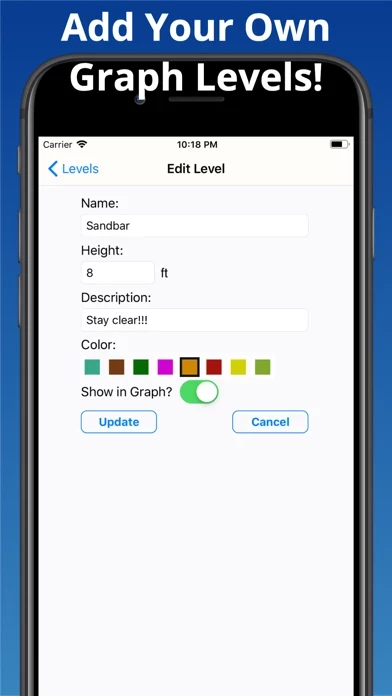
Worth the money! Sure the trend line is great but being able to mark important water levels is what makes Rivercast so great! These levels are included on the graph of river level for ease of comparison.

No Wasted Time

2022-12-30

We have property 2 hours away to hunt and fish. I used Rivercast because it was accurate. The water has to be low for fishing success. If it rains heavily and water is running and it’s high- waste of time and gas. Rivercast saved me time and money. It is accurate on the water levels. I need the water 2.0 and lower for great fishing, Rivercast the best so far on accuracy. It has a place for on the levels page to mark the height of water. Before Rivercast I would take my chances, now, I’ll get the rods ready and head up to the steam because of this apps “point on “water levels. What a great app for me. It has worked very well. Excellent.

Efficient, simple, easy to use.

2023-01-31

My go-to app as a hydrologist. I use it daily to check the current flows and forecast. Data is pulled directly from each agency and combined in the nice graphic interface. I like the crosshairs for grabbing exact values. Very useful.

River Cast

2023-03-04

A very serviceable app. Easy to use, and accurate. Only improvement would be either real-time readings, or something better than a two hour update.

Bought the upgrade, Doesn’t work at all!!🤬

2023-04-02

Emailed the developer and so far, no response!
I paid for the upgrade and I only have access to today’s river stage...
So I try to access the premium upgrade and it still wants to sell me the upgrade, then I clicked on it and it tells me I already bought it!
So I hard rebooted my phone and deleted Rivercast and reinstalled it to no avail...

I’m about to give up and look for another app!!

I live on the Mississippi River flood plane and have a very limited window to move before the water is in my yard!

Real-time information super useful

2023-05-04

Commuting around rivers and living near one has kept me up to date about flooding in my area. It seems they are always finding ways to make Rivercast a little better.

Knowledge in action

2023-06-04

As a sportsman fishing regularly I depend on Rivercast, fish bite better when the Sabine River is falling, my years of fishing, taught me this, my trips have been so much more productive, thanks for a great source of information. Many have Equiment that has to be moved in high water, this stops losses for camps, logging, recreation. Good tool,

Best river app out there

2023-07-06

I’ve tried a lot of river apps and this is by far the best. I really like the ability to set up custom river levels in the graph. Living near a river that floods every winter I use Rivercast a lot. I wish there was an ability to set up a custom alert when a river hits a certain stage though.

Excellent app

2023-08-06

Rivercast provides clear info into River stages allowing safe choices for travel and to know if one’s own home or that of a loved one needs precaution. It does exactly what it says and I’m only on basic. Highly recommend in today’s unpredictable climate.

Vital information!!!

2023-09-07

Rivercast is extremely useful for anyone who lives near rivers. We live in a flood prone area, after storms Rivercast makes it easy to see the water levels of river crossings. Flood stage is marked for all and when possible a future trend is included. This is not only interesting, it is vital information!!! Great for boaters too.

Larry

2023-10-09

Love Rivercast, just wish it would show more history… I use Rivercast for planning my salmon and steelhead fishing trips. No one can predict very accurately where river levels will be more than a few days to perhaps a week ahead. But seeing more history would be very handy as well… So I can go back and see where the river level was when we had a great day.

Great App For Fisherman To Watch River Levels

2023-11-09

Rivercast is the real deal! I had an issue that was quickly resolved and I stand corrected and I do apologize for suggesting any ill thoughts about Rivercast or its developers in a previous post. Cory (a developer) reached out to me and the issue was a glitch either on my end or theirs but nonetheless the issue was resolved efficiently and professionally. This is a great app and I would encourage anyone to subscribe for the premium content especially fishermen that need to know what the river is doing so they can plan their trip accordingly. Get Rivercast. Great information and class acts running it!

Everyday Use and Reliability

2023-12-11

I've been a guide in Montana for 15+ years and as an owner of an outfitting business here, Rivercast is huge for not only my businesses day to day operations but for my days off as well. Because we offer trips on so many waters across the state and YNP, we have guides fishing different waters and stretches daily. I used other similar apps before but the map layout and favorites on this one make it so much quicker and easier to use. You'll never find one with all of the gauge stations and data, but these guys are close and they keep working on it. Great app and as a fourth generation Montanan and guide, I highly recommend it.

Farmer

2024-01-11

Like the old format far better. Can’t tell what is what anymore.

Before, could see where flooding was generally by the coloration as zoomed out. Can’t do that anymore. Really, really dislike the icon changes to all orange and combining reporting stations. Want old version back!!!

Wish I could see more gauge history

2024-12-16

I like looking back to a time when I know something was flooded, like my favorite duck hole, then I can reference what the gauge level was back then and compare to now - this app doesn’t allow you to look back more than a day or so :/

Everyday Use and Reliability

2024-12-16

I've been a guide in Montana for 15+ years and as an owner of an outfitting business here, Rivercast is huge for not only my businesses day to day operations but for my days off as well. Because we offer trips on so many waters across the state and YNP, we have guides fishing different waters and stretches daily. I used other similar apps before but the map layout and favorites on this one make it so much quicker and easier to use. You'll never find one with all of the gauge stations and data, but these guys are close and they keep working on it. Great app and as a fourth generation Montanan and guide, I highly recommend it.

Chris Dickinson
2021-10-21

The forecasts for the rivers Ure, Swale,Tees and Wear have stopped being available over the last few days. Does anyone know if and when they will return.


Is Rivercast Safe? 🤗🙏


Yes. Rivercast - Levels & Forecasts is very safe to use. This is based on our NLP (Natural language processing) analysis of over 9,322 User Reviews sourced from the Appstore and the appstore cumulative rating of 4.7/5 . Justuseapp Safety Score for Rivercast Is 51.3/100.


Is Rivercast Legit? 💯


Yes. Rivercast - Levels & Forecasts is a totally legit app. This conclusion was arrived at by running over 9,322 Rivercast - Levels & Forecasts User Reviews through our NLP machine learning process to determine if users believe the app is legitimate or not. Based on this, Justuseapp Legitimacy Score for Rivercast Is 68.6/100..


Is Rivercast - Levels & Forecasts not working? 🚨


Rivercast - Levels & Forecasts works most of the time. If it is not working for you, we recommend you excersise some patience and retry later or Contact Support.


Payments 💸🤑💰

**Pricing data is based on average subscription prices reported by Justuseapp.com users..

Pricing Plans Amount (USD)
Rivercast Premium Plus $8.99


How was your experience with Rivercast - Levels & Forecasts? Post a Review


Features

- Official Flood Warnings & other alerts from the National Weather Service

- River stage height in Feet

- River flow rate in CFS (when available)

- Indications that a river is at or approaching flood stage

- Current observations and recent history

- NOAA river forecasts (when available)

- Map interface that shows where river gauges are located geographically

- Search interface to find river gauges by waterway name, state, or NOAA 5 digit station ID

- Interactive graphs that can be zoomed in, zoomed out, or panned

- Customizable graphs by adding river levels that are relevant to the user

- Favorites list for locations that the user cares about the most

- Shareable graphs via iMessage, Email, Facebook, or Twitter

- Widget to monitor favorite locations at any time

- Color-coded map that indicates whether the location is at normal levels, approaching flood levels, or above flood stage

- Latest observations from the map, search, or favorites

- Detailed interactive hydrograph that can be accessed with an additional tap

- Ability to add own level lines to customize graphs

- Uses the latest observation and forecast data available

- Requires an Internet connection for use

- Favorites, Map "Instant Observations", and Hydrograph data is viewable in feet or cfs (when available)

- All observation and forecast data is in the user's local time

- USA-only river gauges reported

- Uses NOAA and AHPS for its raw data for custom graphing and mapping solutions

- Variances in CFS data may sometimes occur due to using different data models

- NOAA issues forecasts for many, but not all, rivers it monitors

- River gauges occasionally have technical problems transmitting their data or can get washed out during extreme flooding

- Includes all stations that NOAA provides for public use.

  Customer Service/Support
Developer:
Juggernaut Technology, Inc.

Contact e-Mail:

Website: