Wildfire Info Reviews
Published by David Gross on 2025-01-24🏷️ About: Browse current wildfire and prescribed burn activity throughout all of the world. Active Wildfire Perimeter full data from WFIGS and IRWIN updated every 20 minutes.

🏷️ About: Browse current wildfire and prescribed burn activity throughout all of the world. Active Wildfire Perimeter full data from WFIGS and IRWIN updated every 20 minutes.
We Investigate the app owner's website (Davidgrossapps.com), verify their legitimacy, and uncover hidden scams and complaints.
- Provides outlooks for the country
- Helpful for those who travel and want to stay informed about active wildfires
- Developer is responsive to user issues and concerns
- Provides up-to-date information for those living in areas prone to wildfires
Next to a Washington State Forest. And every summer we worry about forest fires from tourists flipping their cigarettes out on the road in the forest or campfires not put out properly. Or tourist randomly shooting their guns in the forest sparking off a wildfire. But there's nothing here for Washington state. So it does me no good. I'll be deleting WildfireInfo and look for a WA State app.
WildfireInfo crashes immediately upon launch. I’ve tried deleting and reinstalling several times to no avail
WildfireInfo is useless. Wildfires have been raging for 2 days in Napa and Sonoma counties in California with extensive evacuation orders. I’ve been trying to get information but there’s not a peep re. things like CAL Fire incident reports or updates via WildfireInfo. The best I can do is stale information from the San Francisco newspaper.
The map will not display.
Shows pins and thats all, nothing more.
Using IOS 12.4.1.
The Wildfire app is days behind current events and not effective for emergency public information. I have stopped using it in favor of local emergency services reports.
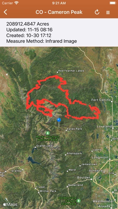
While this looks like a good app, it’s very inconsistent. Many fire perimeter maps are not available. That should be the most important item to show.
Sounds like a great idea, but it crashes on my iPad 10.5
The information on WildfireInfo is usually out of date. It shows fires that have been put out months ago.
This is an awesome app for quick access to California Fire status. It streamlines access to fire maps and twitter feeds. Thank you!!
Inciweb is my go to website for all active wildfire events. I do not live in an area prone to wildfires but I do pay close attention to them as I do travel quite a bit.
Along with Inciweb WildfireInfo provides outlooks for the country.
Awesome app!
Lots of links to any Wildfire info you may need in one location. Nice job.
Really enjoying WildfireInfo so I can keep tabs on southern California wildfires. Does everything you'd want it to do. Thanks!
Thank you so much for such a great app - I had some trouble initially with the fire map not showing anything except the topographical map. The developer contacted me. I deleted and then downloaded WildfireInfo again. It is now working perfectly.
This is a crucial app if you love in wildfire country. The developer (David) responded rapidly to my feedback. I’m grateful for this invaluable app and hope it continues to be so well supported and evolved.
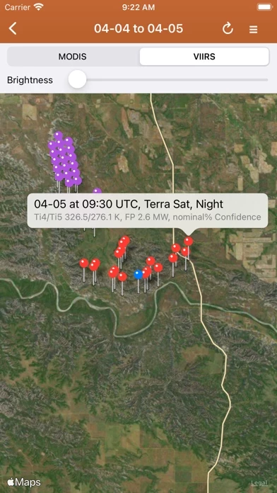
Minor suggestions- allow users to bookmark favorite twitter feed for their area. And perhaps explanation of how to interpret the power ratings of MODIS VIIRS readings.
Overall- 5 stars.
Haven't had a chance to use it much yet but it has several sites with up to date information since it is pulling directly from the sources. Not a great interface but it does pull these sources together on one page.
who needs the hyperbolic news when you can just get actual fire data direct from reliable sources. love WildfireInfo - especially when my mom texts from montana with whatever recent sensationalist nonsense the TV has had to say about fires here in california. 5 stars.
First, to all the reviewers who don’t know, the ‘Cal’ in Cal Fire stands for California (formerly CDF or California Department of Forestry).
This is your first stop for information on wildfires in California so that is where the priority information emphasis is
The Cal Fire active fire map is your number one first stop to see the morning and evening report stats and assess each fire in the state. Having the Twitter feed included is golden. Those two features alone are worth having this in you pocket if you use them for work (as I do) could be threatened by an active fire or just want to know what’s going on.
(Note - I write very few reviews and am not a Cal Fire employee, but my work puts me at many of the state's biggest wildfires)
Minimalistic app, providing the MODIS and CAL Fire and other useful maps.
Living in a drought area of California where wildfires have happened, I check this site at least twice daily. Thanks for making me feel more secure.
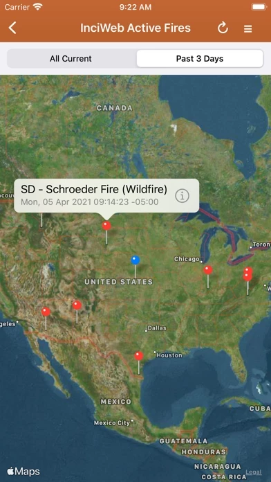
Names fires, gives you size and that's about it. Looking for an app with details like the website inciweb, coordinates, fuel type, movement, projected containment, etc.
It looks like a good app, but it just crashed every time I tried to open it.
I live near Nacimiento Lake and after 3 days no mention of this fire. I was looking for an app that would show a map. Quick link to CalFire only good thing. I deleted it.
There is a huge fire (Thomas Fire) but most maps are blank or have sparse push pins so WildfireInfo is useless
Just updated on ios12 and now WildfireInfo doesn’t even refresh.
I’m trying to track fires in my area!!!
Update - developer says there was a server issue. Still a great app!
Wildfire Info appears generally safe, but use with caution.
JustUseApp Safety Score for Wildfire Info is 34/100.
This assessment is based on our NLP analysis of 31 user reviews.
Combined with the app store average rating of 3.4/5.
Wildfire Info appears legitimate, though exercise caution.
Our NLP models processed user feedback to estimate legitimacy. JustUseApp Legitimacy Score for Wildfire Info is 34.4/100 .
This conclusion is based on analysis of 31 user reviews.
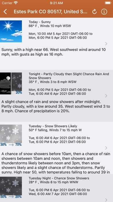
Lookup current hyper-local weather conditions, including temperature, wind and gust conditions, and local forecasts anywhere in the USA, Canada, or Australia using map quick lookup or, for USA, search: Detailed NWS Forecast, Hourly Forecast, Grid Data Forecast, and Summary Forecast.
Premium Users: Lookup a driving route to any fire or hotspot with Google or Apple Maps directions Universal Links.
A Recent Wildfire News section: find news from 1,700+ cited sources quickly on a map or in a table view tagged by state alphabetically.
NASA MODIS and VIIRS satellite instruments: Thermal hotspot maps by region show wildfire activity in the past 48 hours.
There is a section for wildfire-related US government Twitter accounts viewable by map by approximate location or sorted into national and state sources in a table view.