Topography Lite Reviews

Topography Lite Reviews

Published by on 2024-11-16

🏷️ About: The application is very useful to Civil Engineers, Architects, Surveyors, and those interested in measuring a surface area or converting its coordinates to UTM EGSA87. This tool enables users to: 1.


Overall Customer Experience 😎


🤬 Negative experience
69.9%

🫥 Neutral
17.5%

😎 Positive experience
12.6%

~ from Justuseapp.com NLP analysis of 1 combined software reviews.


Summary of Customer Reviews (Takeaways): 💎

- None mentioned in the review.


Read 3 Customer Service Reviews 😠💢

4.0 out of 5
Doesn't do anything

Ads block important parts of the screen and can't find the button to drop the pin, which is necessary.

Too many ads

I could never get it to work. The ads cover everything, so I couldn't even add one marker. Totally deleting

Garbage!

TopographyLite is hidden behind advertisements. The only thing it would be good for is measuring the area of property with known boundaries...it is not a GPS (and doesn't claim to be).


Is Topography Lite Safe? 🙏

No. Topography Lite does not seem very safe to us. This is based on our NLP (Natural language processing) analysis of over 1 User Reviews sourced from the Appstore and the appstore cumulative rating of 4.0/5 . Justuseapp Safety Score for Topography Lite Is 15.3/100.


Is Topography Lite Legit? 💯

No. Topography Lite does not seem legit based on our analysis. This conclusion was arrived at by running over 1 Topography Lite User Reviews through our NLP machine learning process to determine if users believe the app is legitimate or not. Based on this, Justuseapp Legitimacy Score for Topography Lite Is 36.4/100..


How was your experience with Topography Lite? Post a Review


Features

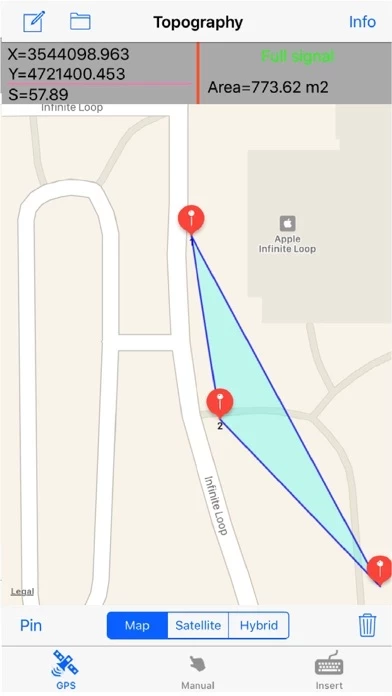
Η εφαρμογή είναι πολύ χρήσιμη για Πολιτικούς Μηχανικούς , Αρχιτέκτονες , τοπογράφους , και σε όσους ενδιαφέρονται για τη μέτρηση μιας επιφάνειας (γεωτεμαχίου, οικοπέδου κτλ) ή για την μετατροπή των συντεταγμένων της σε UTM ΕΓΣΑ87.

Users may also have their final measurements by entering the coordinates either in EGSA87 Datum or Latitude and Longitude in decimal degrees.

The text file contains coordinates either in EGSA87 Datum or Latitude and Longitude in decimal degrees.

Send the above measurements by e-mail in [dxf] file format.

Send measurements by e-mail in [kml] file format.

  Contact Support
Developer:
Georgios Graikousis