SkyDemon Reviews

SkyDemon Reviews

Published by on 2023-12-10

About: SkyDemon is Europe's favourite software for VFR flight planning and in-flight
navigation. Use this app to access your SkyDemon subscription on your iOS
device, unlocking SkyDemon's powerful features while on the move.


About SkyDemon


What is SkyDemon?

SkyDemon is a VFR flight planning and in-flight navigation app that provides access to SkyDemon subscription on iOS devices. It offers powerful features such as vector charts, virtual radar, pilot log facility, plates and documents for airfields, TAF, METAR and SIGMET briefing, rainfall data, GAFOR route forecasts, NOTAM briefings, warnings for airspace and potential hazards, airfield admin information, forecast winds aloft, flight performance profile, ATS routes mode, fuel, weight and balance calculations, user-defined waypoints, track log analysis, and GPS navigation features such as intelligent warnings, virtual radar, vector map, clear and concise instruments, HSI/ILS instrument, live pilot log, TerrainSafe, Direct To, approach information, live updates of TAF and METAR, extended runway centrelines, and position reporting.


Features


- SkyDemon vector charts with dynamic airspace clipping and choice of map layers

- Simple route planning with touch and drag feature

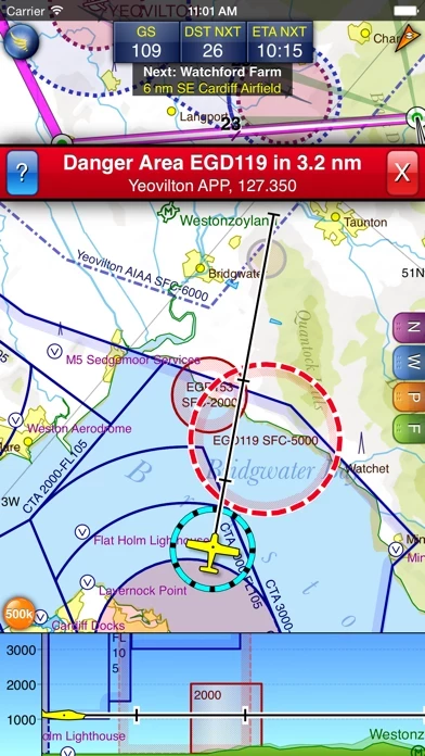
- Virtual Radar to show route relation to airspace, terrain, obstructions, and other features

- Pilot Log facility to calculate headings and groundspeeds from actual wind data and show useful frequencies

- Automatic display of plates and other documents for relevant airfields, many of which are georeferenced for use in flight

- Intuitive pan, pinch, and rotate support with no loss of map clarity or text legibility

- VFR flightplan filing directly to air traffic controllers

- Automatic TAF, METAR, and SIGMET briefing with graphical decoding

- Rainfall data overlay on the main map with animation showing the trend of rainfall over time

- Integration of GAFOR route forecasts for Switzerland, Austria, Slovenia, and Croatia

- Narrow-route and area NOTAM briefings available, updated as you plan

- Advanced NOTAM graphical interpretation and depiction on the main map

- PLOG and briefing output printing

- Warnings for airspace and other potential hazards to your flight, updated in real-time

- Airfield Admin Information showing useful contacts and other details for airfields featured in charts

- Forecast winds aloft automatically retrieved for the flight time and displayed on the map

- Advanced flight performance profile creation for each aircraft used

- ATS Routes mode offering an alternative chart presentation for flight along airways

- Accurate fuel, weight, and balance calculations including flight costings

- Unlimited user-defined waypoints creation

- Track log analysis for posterity

- Six different vector chart styles to choose from

- Extensive European chart coverage as standard

- Intelligent warnings for approaching airspace, NOTAM, obstacles, terrain, and other hazards

- Virtual Radar showing a side-on projection of all approaching features and how your trajectory relates to them

- Vector map automatically following the aircraft in north up, track up, or course up orientation

- Clear and concise instruments showing flight statistics and helping keep on track

- HSI/ILS instrument helping keep to planned route and line up early for approach

- Live Pilot Log showing progress through the route, ETAs, ATAs, and useful frequencies based on current position

- TerrainSafe dynamically coloring mountainous terrain around to quickly identify safer areas

- Direct To allowing easy re-routing in a hurry by picking from a selection of nearby airfields

- Approach Information showing runway diagrams, TAF, METAR, NOTAM, and other airfield details useful for making an approach

- Live updates of TAF and METAR while in flight, with associated alerts*

- Extended runway centrelines appearing automatically on the map as nearing destination airfield

- Permanent display of position relative to nearest well-known waypoint, for position reporting

- Easy changing of the planned route while in flight by touching and dragging.


Overall User Satisfaction Rating


Negative experience
54.3%

Positive experience
45.7%

Neutral
16.0%

~ from Justuseapp.com NLP analysis of 487 combined software reviews.

Key Benefits of SkyDemon

- Easy to use

- Intuitive interface

- Helpful for inflight navigation

- Worth the money


18 SkyDemon Reviews

4.8 out of 5

By


Wouldn’t want to do without SKYDEMON

For me this is an awesome easy to use app, well worth the money, waiting for the SkyDemon to evolve to seeing other users inflight 🙏🏼🇿🇼


By


A few additions would be greatly appreciated

The product should develop more capabilities for IFR flying
1) synthetic vision
2) possibility to file IFR flight plans to eurocontrol
3) recommend recently filed flight plans for the route that the user wishes to fly.
These last 2 feature would eliminate the need to subscribe to Rocket Route and could definitely represent great value
4) possibility to subscribe to and integrate Jeppesen IFR charts
5) integration with ADL210 device for weather, METARs and TAFs coverage across Europe.
All there capabilities are already present on ForeFlight which is now available in Europe and I am tempted to migrate to ForeFlight.


By


Pilot holding a PPL license

This is an excellent APP that I used during my flight
In Bournemouth with stratus device.
Hope that to get more future updates
Thanks
Essa Jaafar


By


The best in the UK.

Tried runway HD, didn’t think it was as easy. this app is intuitive, easy, and mega helpful. Such a good app. Worth every penny.


By


Excellent

This is the best soft ware we ever came across
Easy to use and priced very reasonable


By


Probably the best offering out there for VFR

I downloaded the trial version and was impressed that you can share data across platforms with ease. I create plans on the desktop and save them to the cloud and can open them right on the ipad, and vice verse. In addition to my frequent VFR flights, I love daydreaming about places to go and armchair flying. SkyDemon will be a sure purchase as soon as my foreflight subscription is up in a few months. Look foreword to the replacement but not ready to throw the money out the window. This is much more suited for a bumpy VFR flight.


By


Very Good VFR Navigation App in Europe

Very good VFR navigation app in Europe.


By


Best VFR App for Europe by far

Best VFR App for Europe by far

Keep up the good work!


By


Ron

Have used Fore Flight and WingX and new Garmin for IPad . This Fly Demon, beats them all. No more North up, this has either North up or Route up for navigation, also has a useable a glide slope in panel instrumentation format....add google earth -route depiction for virtual synthetic vision and say good bye Garmin . This is the best so far. Do still like WingX as runner up.


By


Fixed the problem great app and fast support

Have loaded it into my iPad 3 times does not work? I am running a iPad 1 with the latest update have asked for support will update with sky demons reply

Service support was quick and solved the problem as my iPad was set to Hong Kong changed it to U.K. and it now works map integration with flight planning tools notams Taf's metars is excellent and is a great tool for the iPad pilot will report back after I have used it on a few more flights but so far I am very impressed.


By


Just amazing

Great app!


By


One star missing because of Iceland

Very impressive app, and it would even be helpful for me if you would add Iceland in your maps as I live and fly in Iceland :-)

With best wishes and hopes for us few but interested!


By


Germany flying

Having received my pilots license in Wyoming I was unprepared for the congested airspace above Germany. With all the restricted airspace and congestion this app gave me the confidence I needed to be able to fly here. Wouldn't try it without it.


By


Great app, ...

Probably full support for iPhone 6 plus will be done soon ( does not use full screen size)
Otherwise 👍👌 this is IT!


By


Can't log on

Downloaded to my iPad 3 and program asked for my logon name and password. Of course, I never had a chance to register, so nothing worked. Very frustrating.


By


Terrible

Tried to log in to get started. No button to get set up. No button to even reset password, as if I had one.


By


Excellent tool, but NOT for US pilots

Was just informed by this app tech support that they have no intention of supporting US-based pilots. Strange, because they provide US maps, plates, etc. But there are several features that don't work at all for US, including NOTAMs and TFRs - a rather critical gap in flight planning coverage. this app also translates the METAR visibility data into meters and converts the altimeter settings into millibars - again useless for US pilots. This caused me to drop my rating for SkyDemon from 5 Stars to 3 Stars, because it listed in the US App Store, but isn't usable (at least for all it's advertised capabilities) by US pilots!

OK, with those drawbacks clearly stated and out of the way, I have to say that I'm really disappointed that I won't be able to use this as my primary flight planning tool. For those of you in Europe, this is probably the best app of its kind - an easy "5-Star" rating for the Euro pilots.

It provides the most complete planning capability, including fuel planning (with configurable reserves and a factor for "contingencies" that make it highly unlikely to inadvertently run out of fuel on any this app flight plan...

The ability to create multiple "cruise profiles" for your airplane (think 'different power settings and fuel burn rates') as well as climb/descent profiles means that this app can accurately tell you where to begin your climb (or descent) in order to be at the target altitude at the right time/place, and correctly predict the fuel requires to perform the flight.

During the planning cycle, you get warning when your enroute altitudes are below the minimum safe altitudes for that segment, and you can adjust individual segments accordingly.

The "profile view" lets you visualize the vertical flight parameters along your route, and jump immediately to a specific point on the "top-down" view to add a waypoint, or just to get a better perspective.

In summary, for Euro pilots, this could be the best tool around, and well worth the price of the software.

But if you are a US pilot, this app could be a useful planning aid, but you should NOT plan to rely on it as your primary software. Lack of US-based visibility and altimeter setting info in the translated METARs, lack of any TFR info, and zero availability of NOTAMs are a "fatal gap" in coverage that will force you into another tool.

The company's stated lack of interest in providing support for US pilots is a critical omission to me, and makes me wonder why this app is even listed in the US version of SkyDemon Store. I wonder if Apple even realizes that these folks have no intent to service and support US based users...


By


Bad

Nothing about south america, Very baddd..........!!!!!!!


Is SkyDemon Safe?


Yes. SkyDemon is very safe to use. This is based on our NLP (Natural language processing) analysis of over 487 User Reviews sourced from the Appstore and the appstore cumulative rating of 4.8/5 . Justuseapp Safety Score for SkyDemon Is 45.7/100.


Is SkyDemon Legit?


Yes. SkyDemon is a totally legit app. This conclusion was arrived at by running over 487 SkyDemon User Reviews through our NLP machine learning process to determine if users believe the app is legitimate or not. Based on this, Justuseapp Legitimacy Score for SkyDemon Is 61.7/100..


Is SkyDemon not working?


SkyDemon works most of the time. If it is not working for you, we recommend you excersise some patience and retry later or Contact Support.


Pricing Information

**Pricing data is based on average subscription prices reported by Justuseapp.com users..

SkyDemon subscription on iOS device

- Monthly subscription: €39.99/month

- Annual subscription: €399.99/year


How was your experience with SkyDemon? Post a Review

Leave a comment:


Alternatives