GPS Tracks Reviews

GPS Tracks Reviews

Published by on 2023-12-02

About: "One of the better GPS apps for sporting enthusiasts for the iPhone..


About GPS Tracks


What is GPS Tracks?

GPS Tracks is a GPS app for outdoor enthusiasts that allows them to track their activities, navigate to waypoints, and store their favorite destinations. It is available for both iOS and Mac and can sync data between the two platforms. The app is ideal for hiking, running, walking, biking, photography, hunting, fishing, and military navigational applications.


Features


- Track your location/route of your activity

- Store favorite locations

- Take GPS static observations to average current location for more accurate waypoints

- Easily navigate to waypoints with the waypoint guide on the compass

- Add fully editable waypoints on the fly to your current track either manually or from your favorite locations

- Add a vector as a waypoint with angle and distance

- Convert between four sets of coordinates (Decimal, DMS, MGRS, UTM) anytime

- Glide Ratio is viewable and tracked during recording

- Use degrees or mils for the compass

- Add MGRS Grid overlay to map

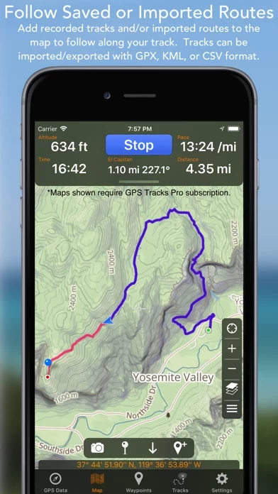
- Create routes to follow manually before you start your track

- GPS Tracks uses WGS84 datum, over 220 datums available with an In-App purchase

- Map measuring tools allow you to measure area and distance on the map

- Draw or drop pins to measure

- Apple Watch App to track your activity directly with your Apple Watch without your iPhone

- iCloud syncing (will sync between Mac, iPad, and iPhone version)

- Import/Export to Dropbox, iCloud Drive, or iTunes File Sharing

- Send locations to the Navigon/TomTom/Google app or the default Maps app for driving directions

- Share your location with friends with a text message (SMS) or email with a direct link to your location on a map

- Import and export tracks/coordinates in a GPX, KML, BIN, CSV, or NMEA format

- Email exported files

- Export track with photos to KMZ file to export your photos taken during the track

- View your track on the map with the ability to replay the route

- View detailed statistics of the track

- View the waypoints saved with each track

- Change track color

- GPS Tracks Pro (Auto-Renewing Yearly Subscription In-App Purchase) allows you to use Street, Terrain, Satellite, USGS, NOAA nautical charts, FAA charts, and many other alternate map sources, save maps for offline use, and use custom Map Tile Server URLs.


Overall User Satisfaction Rating


Neutral
55.9%

Negative experience
54.4%

Positive experience
45.6%

~ from Justuseapp.com NLP analysis of 12,661 combined software reviews.

Key Benefits of GPS Tracks

- Accurately tracks paths and can create maps of them

- Useful for field work in rugged and remote terrain

- Can run tracks and take photo waypoints for work all day long

- Can deliver info straight from the field via text message or email

- Loading external maps and data that have been emailed is easy

- Has a good user manual to help with learning the app

- Can function even when completely lost and far from a cell tower


20 GPS Tracks Reviews

4.7 out of 5

By


Best for Navigating

My new favorite place to walk is a park that has a lot of paths but the paths are not mapped out very well. The only way I knew to create an accurate map of the paths were to simply walk them, and have my phone track me while I walked. I did this using GPSTracks, and only on days where I had a lot of time, since once I picked a path I didn’t know how far it would go or how long I would walked. I simply kept doing this until I had walked all of the paths.

There were so many trails that I didn’t walk them all on one day. I usually walked one trail a week. But the cool thing was that I was still able to create a map that showed all trails at once, so that from then on I was able to pick and choose what trails I wanted to take and even go from one trail to another during a walk.

Other apps didn’t give me that freedom. They only showed one track at a time, and that made it impossible to connect the tracks together. Only with GPSTracks was I able to get the full picture so that I’d be able to pick which paths I wanted to take on any given day or view how long each path I picked would be on the days I didn’t have a lot of time.


By


Professional grade capabilities

As a long time Biological Field Technician I have nothing but good things to say about GPSTracks. I use it daily in the rugged and remote terrain in Hawaii. I have ditched my clunky Garmin handheld unit and can run tracks and take photo waypoints for my work all day long. I’m freed up from needing a PC to transfer data and I can now deliver info straight from the field via text msg or email. Loading external maps and data that have been emailed to me is a cinch.

I use GPS Tracks to inspect conservation fences, track invasive species control and search for endangered plants as well as field navigation. I have even used it while flying to locate helicopter landing zones.

GPSTracks doesn’t have a huge impact on my iPhone 8 battery life. So far it has performed very well when offline/No Service which is imperative in the Hawaiian backcountry. Although I am concerned about using it in a dense forest canopy, perhaps an accessory antenna may help. Love the mapping subscription and benefit highly from the ESRI contour map. Usability is easy to learn and I have gotten a number of coworkers to use GPSTracks on their phones.


By


Search for an effective GPS app

This review is a bit early in my quest for an effective GPS Tracking App. However, what I have seen so far, leads me to think that this is the one that will meet all my GPS tracking needs. Others in their attempt to simplify the process, have left out features that can be very important in certain situations. When you are completely lost, hours from a cell tower, it is nice to have an app that will still function. There is a very good user manual built in, to help get you on the right track. There is a learning curve, but with the well written manual, you can figure it out. Don’t wait until you are lost to try to figure out how GPSTracks works. Use this on your day to day activities and get to know how GPSTracks works before venturing into the unknown. You have to know where you are now and where you have been, to make an intelligent decision on what to do next. I think GPSTracks can achieve my goals if I put in the time and effort to learn how to apply all the features.


By


This IS the app you're looking for..

I reviewed several GPS apps and bought too many useless ones before I found this one. Whatever your application, this is your app. On road or most especially off. It is feature rich and takes a little time to learn all it can do but it's worth every moment and penny. We use it for planning and tracking kayaking trips, mostly on local rivers and waterways. You can review, plan, map, and execute your track by land or water anywhere you can bring up on the map with this tool. Satellite or roadmap views. How far it is from bridge A to bridge B on that river? Go to Tracks tab and trace every bend and oxbow and know exact distance before you hit the water. Looks good? Name it and save it and GPSTracks will guide you down the track you planned. Ditto for hiking. Need a more detailed map? With a reasonable annual subscription a huge array of professional maps for various applications are available for purchase and can be download for permanent offline access.
Driving, hiking, biking, navigating the waterways, this is your guide.


By


Great Replacement For MotionX-GPS

I am a MotionX-GPS orphan. I used MotionX-GPS for years and liked it very much. Now that it's no longer supported I was searching for a replacement. GPS Tracks does just about everything MotionX could do and does much of it a whole lot better. The more I use GPSTracks, the more I like it.

The subscription-based "Pro" version is definitely worth it if you ever have a need to download maps. Since I use this for scuba diving in some remote locations with no Internet, the ability to download and save maps is a must.

I've only had GPSTracks for a few weeks so I'm constantly learning new things about its features and capabilities. I recently did a longish bike ride and hike in a rainforest in Thailand. Having downloaded maps, a reliable compass and accurate tracks made the whole venture easily doable.


By


Frustrating user interface

I chose this over similar better known apps like Gaia and All Trails because it supposedly collects less data but it’s frustrating to use and has essentially no documentation. For example if you recall a previously completed track on the map there’s no obvious way to get rid of it to start a new track. GPSTracks assumes you want to continue and resume the old track even if it’s days later. Then you’re given the choice to save or delete the track you only wanted to view. If you click save it creates a duplicate of the already saved track. Most are not going to click delete for fear of losing their previously saved track. This is a classic example of a competent developer designing an app that works for his needs but isn’t very user friendly to others. Various functions are scattered all over the place with some under obscure icons. A nice simple single hierarchical menu structure would be much better and more intuitive.


By


Heart Rate

UPDATE: “Show Heart Rate” was not showing because I was using the wrong Apple Watch screen to record my track. I should use the first screen, the one that shows the heart rate section, obvious, but I didn’t notice it.
It used to have the ‘Moving Time’ in the tracks, it is no more after latest updates, very usefull info, not sure why it was removed.

Great application. I have the iPhone, iPad as well as the Mac versions. I am using it for all my hiking tracks. I noticed that in the track settings there is a “Show Heart Rate” option that I have it turned on but I can’t see any of that information on either the graph or the track info. When I go hiking I wear my Apple watch and all my heart rate info is recorded on the Health app, but nothing in GPS Tracks!!! Please advise. I thank you in advance for your prompt reply.


By


Outstanding Nav app and customer support

I’m a former B-52 navigator and love GPSTracks for ground navigation and tracking. It’s powerful, intuitive and packed with capabilities for the weekend hiker, the deep woods backpacker, and this avid fly fisherman who will bust brush for miles to find trout while avoiding other fishermen. Just as important, the customer support is EXCELLENT. With more recent iOS updates, some of my iPhone settings were reset and not feeding GPS Tracks properly. David worked tirelessly with me to resolve the issue and GPS Tracks is functioning flawlessly again. Customer support is THE most important criterion for me. If you want an outstanding navigation app AND great support when iPhone updates can leave you hanging, get. GPS Tracks.


By


Some bugs

This is a great app. I live in Manaus Brazil and use it in the largest remaining urban green space within the limits of this sprawling city . The area is the Reserva UFAM. The Federal University of Amazonas Forest Reserve. I’ve yet to use it on expeditions we take in the interior of the State far from internet access. I have two concerns at the moment: 1) Hiding and / or deleting waypoint names from the map is problematic. Also, there is no option for reducing font size of the track and waypoint names. Both of these issues are problematic as they result in superimposed words on the track which I can’t see very well especially
when I include multiple waypoints. On a zoom all one can see are huge words . Am I missing an option in settings or is there an issue with deleting waypoints for good without having to delete the whole track?
Signed
Charles


By


Replacement for Motion X

Very reasonable app. Good amount of features. Nice layout. Using offline maps is a little clunky but once you get the hang of it, it’s fine.

Don’t recall what the version was when I did my first review. This update is for 3.78.
Reached out to David regarding a minor interface issues I was having with a version 3.77 update. He responded within hours and a fix was done within less then 72hr. That in itself is pretty good.
A couple of off road groups I associate with use another mapping product named after Greek mythology, it’s a good product. However, IMO, GPS Tracks is just a good, with a similar function set and the bonus of a very responsive development team. All said, I up it to 5 stars.


By


simple and easy to use

This nearly replaced my 400$ Garmin gps. The accuracy is as good as your phone's gps, and it definitely bounces my point around if I stand in one place, creating a jumble of lines, but its OK for my uses. When I need a more consistently accurate track or navigation, I pull out the Garmin. This is also easier to type labels and you can take photos along the track, plus decreases the number of devices I have in the field. It was freezing at one point after my phone updated at one point, but the problem stopped when I restarted the phone a couple times. I use this for my work as a field biologist.


By


Best tracking map Of the center!!!!!👊🏻

GPSTracks is not just ONE of the best, it IS THE BEST ever of all times. I am a root digger and find myself in some locations sometimes that make you think you’re so far in the woods that you may have walked off the earth and I’m here to tell ya, when you’re that far in the woods & no one or nothing could get to you or even try to find you, that’s a very numbing feeling and GPSTracks right here, GPS TRACKS never fails me. It keeps on tracking, providing very useful data and several times now if it wasn’t for GPSTracks, I would’ve been lost, potentially for days or weeks so thank you very much.


By


Best in Class, all the way

I very much admire and highly recommend GPSTracks; it has everything we need and more (but not lots of stuff we don't need). It is frequently updated, and the developer is always working to keep it going strong. I would love to see capability to add video clips of, say, 10 seconds, to waypoints (instead of single photos), and -- most of all -- I would like to have Pro version access higher-resolution satellite imagery. What is gets now is usually not as useful as Google Earth imagery; for the price of the GPS Tracks Pro subscription, imagery should be at least as good as Google Earth. For ease of use and reliability, GPS Tracks is the best of class!


By


A Must Have for Outdoor and Off-road Use

I use GPSTracks almost everyday. I always record my hiking trips with it. It's a fast and reliable app for recording tracks. It has a ton of features for a professional but is easy enough to use by a casual user. I had been using it for months before I discovered a lot of the details features it has included. This is one of the best nav app I have used. Easy to import and export tracks.

I use it mostly to record my routes and analyze them later but sometimes I pre plan routes and waypoints. The details track stats and playback are a must have. There even are measuring tools included for planning purposes. I love the way it syncs both to my iPad and my Mac. This allows me to record data and analyze it on my Mac.

The other day I took it out on an unfamiliar trail and lost my bearings. I used GPSTracks to find my way back which was awesome. I will never go out without using GPSTracks again.

Overall a well done app with great support!

Update - The new cloud sync is awesome, very fast and no more issues, well done guys!


By


The best App I’ve ever used

GPS Tracks is easily the best app I’ve ever used. I use it daily whether I’m mountain biking through the woods or cycling on rail trails, for distance, elevation, waypoints and general navigation. The interface is clean. It is simple to use right off the bat, yet the customizable options seem endless if you choose to dive deep into them. GPSTracks is rock steady and I can’t recall it ever crashing on me in the 8.5 years I’ve been using it since March 2013. The updates to GPSTracks have all been positive over the years, it is obviously a labor of love for the developer. Kudos and thank you for your efforts.


By


Great photography tool

This is an excellent to for photographers. I had heard about GPSTracks from a few blogs and it was highly recommended. I have used it a few times and it seems to be working great. I use it to record the GPS locations to align with my images when I get home. The iCloud sync is also a nice feature to allow me to sync my tracks across all my devices.

There are also other more advanced tools such as the elevation angle calculations to help guide my position for a shoot. This allows me to pre-position my shoot before hand.

Overall this is a very useful app with a lot of great features.


By


Looked awesome, but failed to deliver

UPDATE: Developer contacted me and was able to provide a solution to the Dropbox issue. Initial tests look good. For that reason I have changed my rating!

I was very hopeful that I had found the solution I was looking for. I needed a way to geotag photos taken on location. I needed GPSTracks to upload GPX files to Dropbox. That is where it has failed. Apparently the link to Dropbox is no longer valid. I contacted the developer a few days ago, but no reply. I would not mind using iCloud sync with the desktop app, but not going to pay more money for the desktop version if I can’t get the features I already paid for to work. I guess the search continues!


By


Take that you untruth speaker! ...

I drive for a ride sharing company. ... And I am a photographer. ... I got GPSTracks to document my locations when I am shooting, but I got addicted to looking at the little tracks of where I have been. ... Cool! I have it on all the time now.

Last night I was one half of a two car collision. As a driver, I had installed a dash cam! Yay, they did not stop at a stip sign. But there was no way for the video to document my speed in the 35 mph zone that I was driving in. ... I pulled up GPS Tracks, and saw that the highest rate of speed in the last mile of my approach to the collision was 26.8 mph!

Winner, winner, chicken dinner.


By


I Love it on iphone & ipad3 GSM

Initially I didn't "get it", now it chronicles my life, A+. I am just sorry as hell that Apple is not backwards compatible when their production cycles could have been far ahead of their "evolutions" it is not as if the capacities were not there to begin with the whole experience has been unabashedly malfeasance and a proprietary mess which is a slap in the face of the business user and consumers. While, this is a very worthy application. Go figure.., there is a sense of great deal of integrity in these developers insistence on the superiority of form and function of their app. Not to be duplicated or ever surpassed it is the real article.


By


Wow. Super service.

I have use GPSTracks (the pro version) since 2017. I’ve used it particularly for hiking and biking. It is not only allowed me to track my trips but it’s assisted with navigation as well. I love it.

One thing I enjoy is the ability to use different maps, which can be downloaded and used off-line. I had some minor difficulty with the download and emailed the developer. It was a holiday and I didn’t really expect a response until the next workday. He responded in four minutes. Super service. Solved the problem.


By


Offline mapping seldom works.

Love the GPS waypoints picture tracking! Found it challenging to create routes and tracking when online and offline? Google maps w timeline much easier and automated but not as accurate as GPS tracking. Roads and trails did not show on map when offline? GPSTracks provides a lot more detail and options than google maps, but along with that, much more learning the program and processes. On my last 8 day Jeep trip I used Delorme Topo 10 w GPS device attached to laptop computer, Google maps, and GPS Tracking App. I wish there was an app that combined all 3 Apps into one! Delorme worked best offline but lacked detail of GPS Tracking and ease of use of Google Maps.


By


Handy App and Great Customer Service.

Normally I gravitate to free Apps. But, sometimes it worth paying a few dollars for a useful app! Especially when you are unnecessarily sharing personal information in exchange for using GPSTracks . I chose to buy GPSTracks due to the overall value, features, and limited permissions requirements which didn’t seek to access contacts and other personal information unnecessarily.

I was also pleased by the their customer service when I reached out via email. I received a quick response with all my questions answered!


By


Great app

Does everything it’s supposed to do! Plain and simple! Accurate as the government will allow! Never get lost,hurt without help or your family and friends worrying if you’re ok! They can see with your permission! Even if your phone gets destroyed they can see it’s last location and what plot, waterways or trails you took! I love it and my wife loves it! If I don’t return, she can email the map to help find me quickly! GPSTracks saved my wife and I from needing rescue!! We got lost in the mangroves when we were kayaking. Thank you who ever developed GPSTracks! Mike johansson


By


Still Great app

After several years, I'm still delighted with GPSTracks and the improvements have all been very welcome. I still have a complaint about the fact that waypoints Unrelated to a track get exported along with the track but I can always delete them and it's not a major problem. I have one minor request. Could you add a “delete all” instruction to the waypoint menu? It would help me keep a clean slate and avoid saving temporary waypoints I had a forgotten about. Thank you for your hard work and I really appreciate it


By


Version 3.2 is a downgrad

I love GPSTracks, and I use it all the time. But version 3.2 is terrible! The modern touch that was added in looks alright, but when you try to swipe down, you sometimes bring down the notification menu. I thought it was perfectly fine how it was. In fact the whole user interface was better in 3.1.8
And maybe that’s just a preference thing, but the icon that symbolizes your position and heading, that just spins around the whole time along with the compass at the top. It never stops. I tried closing out and restarting, but it doesn’t help it. I opened up the Apple compass that comes already downloaded and that works just fine. Please just revert to the old dashboard.


By


Works great! Well worth the price!

App worked great, i was able to download hiking trails and upload them directly into GPSTracks , then used the “download maps for offline use” feature and it worked better than I expected, i was in a remote area with ZERO cell service and and my position was very accurately displayed along with downloaded aerial imagery and trail lines. It also very accurately records your route as u hike, along with a lot of additional data. Great app, recommended it to all of my friends, we all use this now.


By


Invaluable documentation tool

I shoot Ariel and Ground video for large ranches in Texas. I generally ride around with the owners viewing different aspects of the property. In the past I always had a hard time remembering where these locations were as some of these wrenches can be quite large. With the use of GPS tracker I can now document not only the points of interest but also the roads and paths in which to get to these locations. This is become an in valuable tool for me when doing my work.


By


GPS is waaay off

While GPSTracks fulfilled my initial intended purpose for use it failed to pass muster.

It did good in that it has accurately tracked my time, distance, and speeds for day hikes and displayed them on a map, which was the reason I downloaded GPSTracks .

Where it fails HARD is waypoints. The GPS coordinates provided were very inaccurate. I am a member of a specialized search and rescue team. Our primary GPS equipment failed during a long operation so I took out my phone to use GPSTracks. We were using GPS waypoints to report locations of victims for recovery. While the pin was in the right spot on the map the coordinates provided, which I sent to command for followup by a recovery team, were several MILES from my location. That part is useless.


Is GPS Tracks Safe?


Yes. GPS Tracks is very safe to use. This is based on our NLP (Natural language processing) analysis of over 12,661 User Reviews sourced from the Appstore and the appstore cumulative rating of 4.7/5 . Justuseapp Safety Score for GPS Tracks Is 45.6/100.


Is GPS Tracks Legit?


Yes. GPS Tracks is a totally legit app. This conclusion was arrived at by running over 12,661 GPS Tracks User Reviews through our NLP machine learning process to determine if users believe the app is legitimate or not. Based on this, Justuseapp Legitimacy Score for GPS Tracks Is 100/100..


Is GPS Tracks not working?


GPS Tracks works most of the time. If it is not working for you, we recommend you excersise some patience and retry later or Contact Support.


Pricing Information

**Pricing data is based on average subscription prices reported by Justuseapp.com users..

GPS Tracks Pro

- Use Street, Terrain, Satellite, USGS, NOAA nautical charts, FAA charts, and many other alternate map sources

- Save maps for offline use

- Use custom Map Tile Server URLs

- Subscription syncs via iCloud to other devices

- 1-year subscription: $19.99 (automatically renewed until canceled)


How was your experience with GPS Tracks? Post a Review

Leave a comment:


Alternatives