Garmin Pilot Übersicht
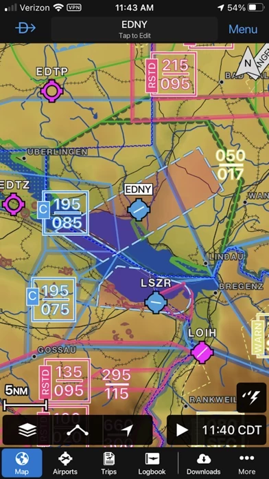
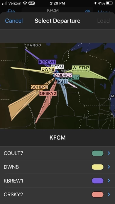
With Garmin Pilot, data can be displayed over Garmin’s interactive maps that support track-up navigation, VFR sectional or an IFR low or high en-route chart to visualize the weather for your route.
Garmin Pilot’s powerful capabilities start with pre-flight planning, providing pilots with the most comprehensive aviation weather information to make better-informed flight decisions.
And when the flight plan is ready, Garmin Pilot makes it simple to file, amend or close the flight plan via Leidos Flight Service or DUATS.
Offizielle Bildschirmfotos
Produkt einzelheiten und Beschreibung von
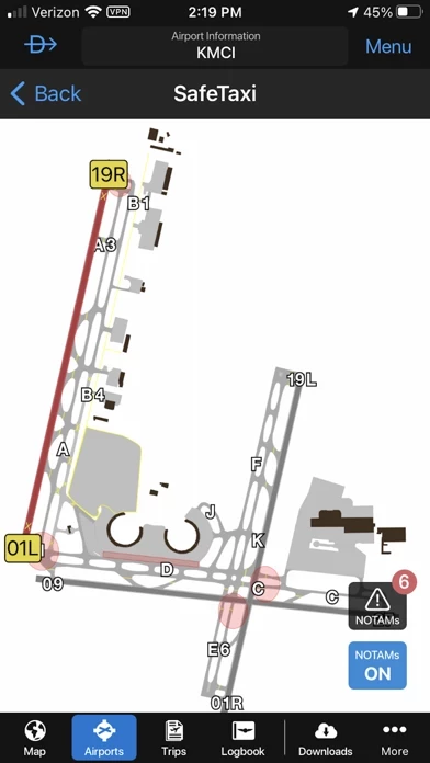
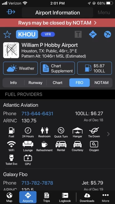
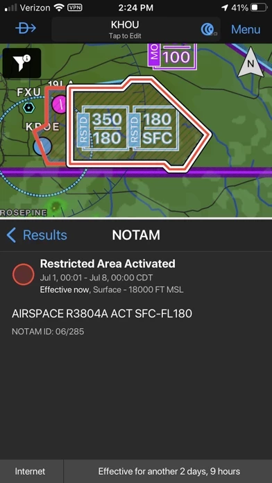
*30 Days Free Trial on initial download!* Plan. File. Fly. Log. Garmin Pilot is the most comprehensive suite of tools for the iPad designed specifically for general aviation and corporate pilots. Flight planning, charts, interactive maps, weather briefing resources and navigation capabilities; it’s all included. The app’s intuitive interface mirrors those on the newest Garmin touchscreen avionics so you can go seamlessly from preflight to inflight. Plan Garmin Pilot’s powerful capabilities start with pre-flight planning, providing pilots with the most comprehensive aviation weather information to make better-informed flight decisions. Pilots can check NEXRAD radar, visible and infrared cloud imagery, METARs, TAFs, AIRMETs, SIGMETs, PIREPs, NOTAMs, winds and temperature aloft, TFRs and lightning data. With Garmin Pilot, data can be displayed over Garmin’s interactive maps that support track-up navigation, VFR sectional or an IFR low or high en-route chart to visualize the weather for your route. Add text-based weather widgets and use the exclusive NavTrack feature to view weather along the planned route. File With Garmin Pilot, users can easily enter a flight plan and interactively edit it on the map. Pre-loaded forms make it quick to save and reuse data for frequently flown routes. And when the flight plan is ready, Garmin Pilot makes it simple to file, amend or close the flight plan via Leidos Flight Service or DUATS. Fly Garmin Pilot provides full en-route navigation capability on its moving map. Pilots can also navigate with Garmin’s patented panel, a GPS-driven instrument pack with a graphical HSI directional display and indicators for groundspeed, altitude and vertical speed. After takeoff, pilots can continue to view real-time weather in the U.S. and traffic information by wirelessly connecting to Garmin’s GDL 39 3D portable ADS-B Receiver (sold separately). Log Garmin Pilot includes a comprehensive electronic logbook that syncs with flyGarmin. The logbook automatically generates entries based upon GPS data collected during the flight, tracks currency, supports manual entries, endorsements and creates reports. Garmin Pilot U.S. Standard: - Rich, interactive maps support Track-Up navigation - Charts: VFR Sectionals, low and high IFR en-route, airport diagrams and approach procedures - Ability to view Jeppesen Terminal Charts (Jeppesen echart subscription required) - Weather Maps: Animated radar, Infrared and Visible Satellite, AIRMETs, SIGMETs, Lightning, TFRs and more! - Extensive text products: METARs, TAFs, Winds Aloft, PIREPs, AIRMETs, SIGMETs, Area Forecasts and NOTAMs - AOPA Airport Directory - Weight and Balance - Checklists - Flight plan filing via Leidos Flight Services - Garmin patented navigation panel - Terrain and Obstacles - Smart Airspace - Fast Find predictive Waypoint Entry - Logbook - Optional VFR Premium: Synthetic Vision (SVX), Terrain and obstacle alerting, and Garmin SafeTaxi® - Optional IFR Premium: VFR Premium plus geo-referenced Garmin FliteCharts® Garmin Pilot has regional offerings for Africa, Asia, Australia, Canada, Europe and Latin America. Features include: - Worldwide Jeppesen NavData - Rich, interactive maps support Track-Up navigation - Radar and Satellite imagery for Western Europe, U.S., Canada and Australia - Ability to view Jeppesen Terminal Charts (Jeppesen echart subscription required) - Worldwide METARs, TAFs, AIRMETs, SIGMETs, NOTAMs and winds aloft - VFR Flight Plan Filing - IFR autorouting and Flight plan filing in Europe - Terrain and Obstacles with alerting - Synthetic Vision (SVX) - Smart Airspace - Logbook - Optional VFR charts from DFS, IGN and NATS and IFR enroute charts from EuroControl - Optional Garmin FliteCharts® and SafeTaxi® diagrams available on a country-by-country basis *Note: Use of GPS running in the background may decrease battery life.* *Note: One subscription to Garmin Pilot may be used on three devices.*
Oben Erfahrungen und Bewertung
durch Icemann3000
Perfekt
Ich hatte alle Apps abonniert die man im Bereich der VFR Fliegerei so kennt. Garmin ist jedoch die einzige die sich wirklich sinnvoll weiter entwickelt. Auch die Möglichkeit das ganze unter IFR zu nutzen ist natürlich hervorragend. Man hat hier ein All-In-One Paket das einem wirklich alles bietet und das in ultimativer Qualität. Preis-Leistung ist absolut perfekt und angemessen.
durch Sneaker_GER
Grundsatzsetup mit 12.1.1 nicht zu nutzen
Ich habe ein neues IOS auf meinen iPhone und iPad installiert. Ergebnis, ich komme nicht zu der Anmeldung , da ist ein Overlay welches das ganze blockiert
durch Ghgdgjgxd
Great tool
Flying mainly in US and somewhat in Germany. US part is affordable and great, VFR and IFR! Thanks for the CAP grids and the Open Street Map integration. Helps saving lives! Germany software too expensive! And data incomplete. But flying in Germany is deliberately made difficult vs in US where pilots are supported at max to stay safe-no matter what size the airframe. Great application and software. Would like to see timezone conversions. Too many timezones and always entering the right converted time in z leads to mistakes. Also would like to have the identifyer letter with the METAR. I see the data but still have to tune into ATIS to get the letter ... Like staying in the Garmin mode of thinking which is in line with the airplane mounted GPSs in functionality and philosophy.