Garmin Pilot Overview
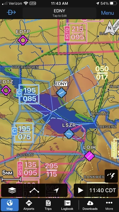
With Garmin Pilot, data can be displayed over Garmin’s interactive maps that support track-up navigation, VFR sectional or an IFR low or high en-route chart to visualize the weather for your route.
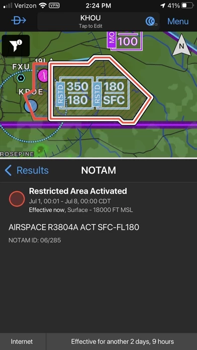
Garmin Pilot’s powerful capabilities start with pre-flight planning, providing pilots with the most comprehensive aviation weather information to make better-informed flight decisions.
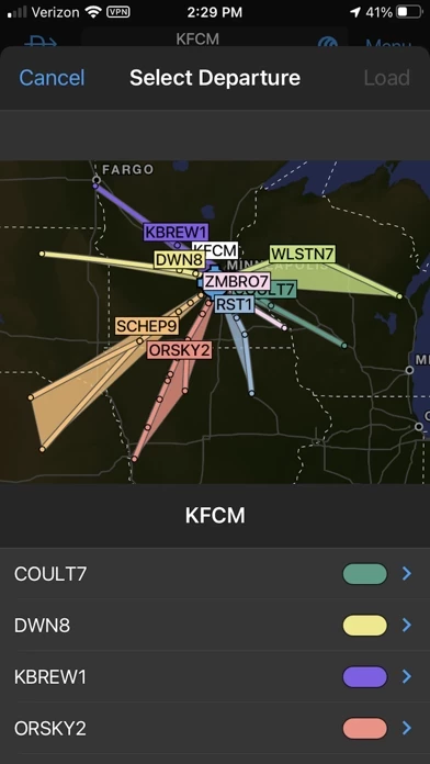
And when the flight plan is ready, Garmin Pilot makes it simple to file, amend or close the flight plan via Leidos Flight Service or DUATS.
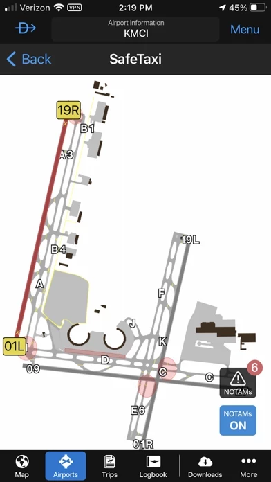
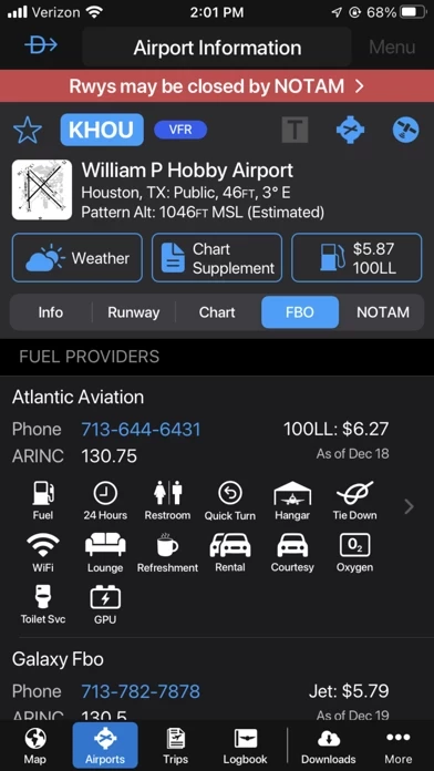
Official Screenshots
Product Details and Description of
*30 Days Free Trial on initial download!* Plan. File. Fly. Log. Garmin Pilot is the most comprehensive suite of tools for the iPad designed specifically for general aviation and corporate pilots. Flight planning, charts, interactive maps, weather briefing resources and navigation capabilities; it’s all included. The app’s intuitive interface mirrors those on the newest Garmin touchscreen avionics so you can go seamlessly from preflight to inflight. Plan Garmin Pilot’s powerful capabilities start with pre-flight planning, providing pilots with the most comprehensive aviation weather information to make better-informed flight decisions. Pilots can check NEXRAD radar, visible and infrared cloud imagery, METARs, TAFs, AIRMETs, SIGMETs, PIREPs, NOTAMs, winds and temperature aloft, TFRs and lightning data. With Garmin Pilot, data can be displayed over Garmin’s interactive maps that support track-up navigation, VFR sectional or an IFR low or high en-route chart to visualize the weather for your route. Add text-based weather widgets and use the exclusive NavTrack feature to view weather along the planned route. File With Garmin Pilot, users can easily enter a flight plan and interactively edit it on the map. Pre-loaded forms make it quick to save and reuse data for frequently flown routes. And when the flight plan is ready, Garmin Pilot makes it simple to file, amend or close the flight plan via Leidos Flight Service or DUATS. Fly Garmin Pilot provides full en-route navigation capability on its moving map. Pilots can also navigate with Garmin’s patented panel, a GPS-driven instrument pack with a graphical HSI directional display and indicators for groundspeed, altitude and vertical speed. After takeoff, pilots can continue to view real-time weather in the U.S. and traffic information by wirelessly connecting to Garmin’s GDL 39 3D portable ADS-B Receiver (sold separately). Log Garmin Pilot includes a comprehensive electronic logbook that syncs with flyGarmin. The logbook automatically generates entries based upon GPS data collected during the flight, tracks currency, supports manual entries, endorsements and creates reports. Garmin Pilot U.S. Standard: - Rich, interactive maps support Track-Up navigation - Charts: VFR Sectionals, low and high IFR en-route, airport diagrams and approach procedures - Ability to view Jeppesen Terminal Charts (Jeppesen echart subscription required) - Weather Maps: Animated radar, Infrared and Visible Satellite, AIRMETs, SIGMETs, Lightning, TFRs and more! - Extensive text products: METARs, TAFs, Winds Aloft, PIREPs, AIRMETs, SIGMETs, Area Forecasts and NOTAMs - AOPA Airport Directory - Weight and Balance - Checklists - Flight plan filing via Leidos Flight Services - Garmin patented navigation panel - Terrain and Obstacles - Smart Airspace - Fast Find predictive Waypoint Entry - Logbook - Optional VFR Premium: Synthetic Vision (SVX), Terrain and obstacle alerting, and Garmin SafeTaxi® - Optional IFR Premium: VFR Premium plus geo-referenced Garmin FliteCharts® Garmin Pilot has regional offerings for Africa, Asia, Australia, Canada, Europe and Latin America. Features include: - Worldwide Jeppesen NavData - Rich, interactive maps support Track-Up navigation - Radar and Satellite imagery for Western Europe, U.S., Canada and Australia - Ability to view Jeppesen Terminal Charts (Jeppesen echart subscription required) - Worldwide METARs, TAFs, AIRMETs, SIGMETs, NOTAMs and winds aloft - VFR Flight Plan Filing - IFR autorouting and Flight plan filing in Europe - Terrain and Obstacles with alerting - Synthetic Vision (SVX) - Smart Airspace - Logbook - Optional VFR charts from DFS, IGN and NATS and IFR enroute charts from EuroControl - Optional Garmin FliteCharts® and SafeTaxi® diagrams available on a country-by-country basis *Note: Use of GPS running in the background may decrease battery life.* *Note: One subscription to Garmin Pilot may be used on three devices.*
Top Reviews
By justingraff
Garmin Pilot is great
I have used it for at least 6 years. Great app. Constantly improving it. Has always had better map readability than ForeFlight, and even with FF’s improved vector based maps Garmin Pilot still is superior. Too numerous to count features. ADS-B weather and traffic works great. I like that they generally add features without adding multiple pricing levels. The only weak area in my opinion is the weather briefing which still just gives an DAA standard briefing, and is the sole reason I keep my ForeFlight subscription. I suspect ForeFlight will improve the preflight weather brief in the future. It even works with my flight simulator that I use to practice instrument approaches.
By lgj1228
Good app.
I just wanted to bring up an issue I am having while viewing winds aloft forecasts. When I slide the time blocks at the bottom over to a future block to view info, the screen will revert to the default current time block. The screen flickers slightly when it happens. If I am copying wind speeds and directions and dont catch the change I’ll be viewing the wrong info and have to slide back to the time block I was viewing. It seems to do it after about 10-15 seconds of viewing a time block. Otherwise, 5 stars. Maybe something can be fixed in a future update.
By Pginz
Long time garmin app user
I have been using this app since it came out. Garmin is awesome at keeping this app current. This is the app to use for flight planning and in the cockpit assistance. It is super user friendly and can be used in rough weather. I believe this is the most pilot friendly app for flight planning and actual in cockpit usability. You need to keep buying new iPads as they come out because the software is pretty heavy. It is packed with horsepower and every two to three years the processors can’t keep up. I have an iPad Pro that’s a year old and does great.