Garmin Pilot Présentation
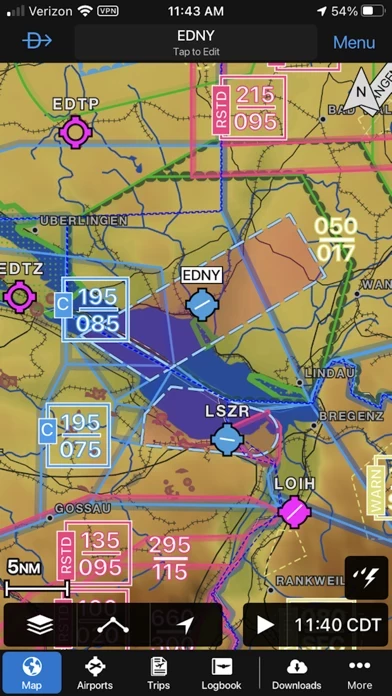
With Garmin Pilot, data can be displayed over Garmin’s interactive maps that support track-up navigation, VFR sectional or an IFR low or high en-route chart to visualize the weather for your route.
Garmin Pilot’s powerful capabilities start with pre-flight planning, providing pilots with the most comprehensive aviation weather information to make better-informed flight decisions.
And when the flight plan is ready, Garmin Pilot makes it simple to file, amend or close the flight plan via Leidos Flight Service or DUATS.
Captures d'écran officielles
Détails du produit et description de
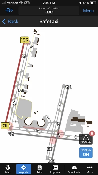
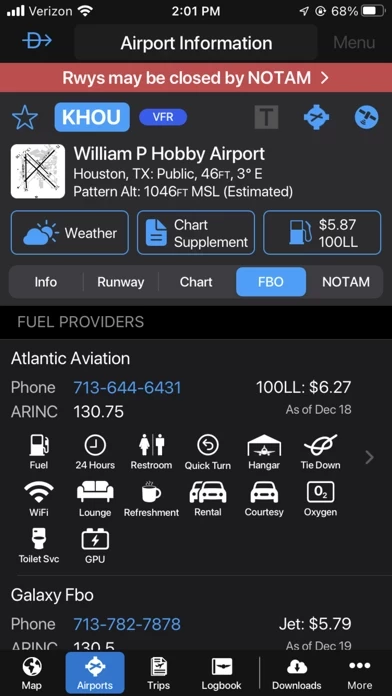
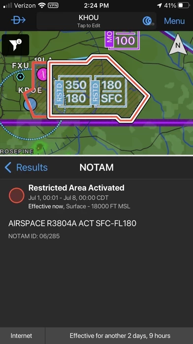
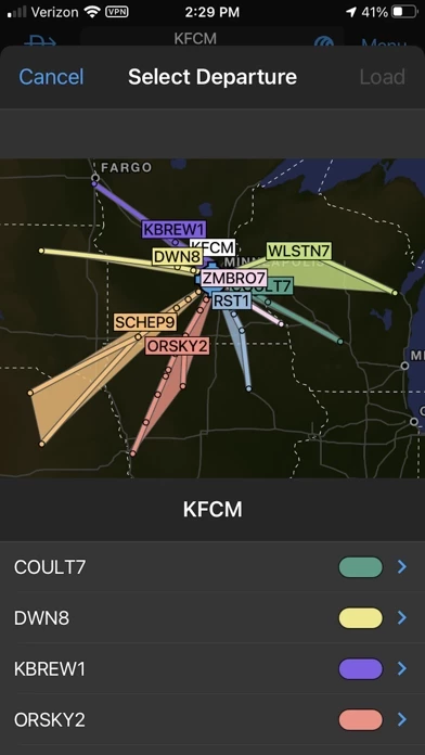
*30 Days Free Trial on initial download!* Plan. File. Fly. Log. Garmin Pilot is the most comprehensive suite of tools for the iPad designed specifically for general aviation and corporate pilots. Flight planning, charts, interactive maps, weather briefing resources and navigation capabilities; it’s all included. The app’s intuitive interface mirrors those on the newest Garmin touchscreen avionics so you can go seamlessly from preflight to inflight. Plan Garmin Pilot’s powerful capabilities start with pre-flight planning, providing pilots with the most comprehensive aviation weather information to make better-informed flight decisions. Pilots can check NEXRAD radar, visible and infrared cloud imagery, METARs, TAFs, AIRMETs, SIGMETs, PIREPs, NOTAMs, winds and temperature aloft, TFRs and lightning data. With Garmin Pilot, data can be displayed over Garmin’s interactive maps that support track-up navigation, VFR sectional or an IFR low or high en-route chart to visualize the weather for your route. Add text-based weather widgets and use the exclusive NavTrack feature to view weather along the planned route. File With Garmin Pilot, users can easily enter a flight plan and interactively edit it on the map. Pre-loaded forms make it quick to save and reuse data for frequently flown routes. And when the flight plan is ready, Garmin Pilot makes it simple to file, amend or close the flight plan via Leidos Flight Service or DUATS. Fly Garmin Pilot provides full en-route navigation capability on its moving map. Pilots can also navigate with Garmin’s patented panel, a GPS-driven instrument pack with a graphical HSI directional display and indicators for groundspeed, altitude and vertical speed. After takeoff, pilots can continue to view real-time weather in the U.S. and traffic information by wirelessly connecting to Garmin’s GDL 39 3D portable ADS-B Receiver (sold separately). Log Garmin Pilot includes a comprehensive electronic logbook that syncs with flyGarmin. The logbook automatically generates entries based upon GPS data collected during the flight, tracks currency, supports manual entries, endorsements and creates reports. Garmin Pilot U.S. Standard: - Rich, interactive maps support Track-Up navigation - Charts: VFR Sectionals, low and high IFR en-route, airport diagrams and approach procedures - Ability to view Jeppesen Terminal Charts (Jeppesen echart subscription required) - Weather Maps: Animated radar, Infrared and Visible Satellite, AIRMETs, SIGMETs, Lightning, TFRs and more! - Extensive text products: METARs, TAFs, Winds Aloft, PIREPs, AIRMETs, SIGMETs, Area Forecasts and NOTAMs - AOPA Airport Directory - Weight and Balance - Checklists - Flight plan filing via Leidos Flight Services - Garmin patented navigation panel - Terrain and Obstacles - Smart Airspace - Fast Find predictive Waypoint Entry - Logbook - Optional VFR Premium: Synthetic Vision (SVX), Terrain and obstacle alerting, and Garmin SafeTaxi® - Optional IFR Premium: VFR Premium plus geo-referenced Garmin FliteCharts® Garmin Pilot has regional offerings for Africa, Asia, Australia, Canada, Europe and Latin America. Features include: - Worldwide Jeppesen NavData - Rich, interactive maps support Track-Up navigation - Radar and Satellite imagery for Western Europe, U.S., Canada and Australia - Ability to view Jeppesen Terminal Charts (Jeppesen echart subscription required) - Worldwide METARs, TAFs, AIRMETs, SIGMETs, NOTAMs and winds aloft - VFR Flight Plan Filing - IFR autorouting and Flight plan filing in Europe - Terrain and Obstacles with alerting - Synthetic Vision (SVX) - Smart Airspace - Logbook - Optional VFR charts from DFS, IGN and NATS and IFR enroute charts from EuroControl - Optional Garmin FliteCharts® and SafeTaxi® diagrams available on a country-by-country basis *Note: Use of GPS running in the background may decrease battery life.* *Note: One subscription to Garmin Pilot may be used on three devices.*
Haut Avis
Par niala nourlov
Garmin Pilot : Très bon produit
L’appli que j’utilise systématiquement en IFR, avec les cartes Jeppesen intégrées. Très opérationnel et efficace. Le radar météo est très bien représenté et très fiable - avec un décalage temporel de 15 a 30 minutes. L’Autorouting marche pas mal mais moins bien que Foreflight, où le dépôt de plan de vol est imbattable. Néanmoins Garmin lui est supérieur sur pas mal d’autres points, sans parler des graphismes... Le Safetaxi est très bien fait et très pratique pour se repérer sur une grosse plateforme, l’enregistrement automatique des vols très performant, avec Wheels off / wheels on. La carte de France du SIA est chargeable, on aimerait aussi pouvoir charger les cartes régionales du SIA.
Par flush royale
Encore un petit effort
Pourquoi un classement des stored flight plan par ordre d’enregistrement et non par ordre alphabétique. Même Excel sait le faire . Bravo pour l’envoi des flight plan par flight stream 510 vers le G 1000 .
Par Flyhigher_fr
Bon app mais...
Depuis quelques temps, impossible d’avoir les vents, et même plus de couverture SIGWX sur l’Europe....