RadarScope is a specialized display utility for weather enthusiasts and meteorologists that allows you view NEXRAD Level 3 and super-resolution radar data along with tornado, severe thunderstorm, flash flood, special marine and snow squall warnings, and predicted storm tracks issued by the U.S. National Weather Service.
It can display the latest reflectivity, velocity, dual-polarization, and other products from any NEXRAD or TDWR radar site in the United States, Guam, Puerto Rico, Korea, and Okinawa, as well as data from Environment Canada, Australian Bureau of Meteorology, Finnish Meteorological Institute, and German Weather Service radars.
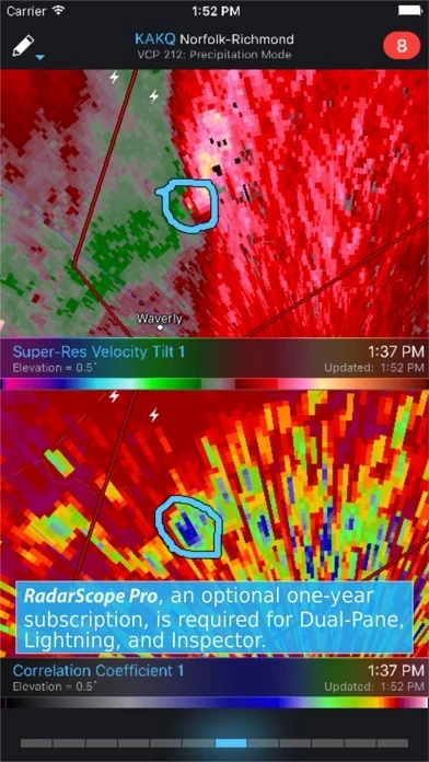
Whether you are scanning reflectivity for a mesocyclone's tell-tale hook echo, trying to pinpoint the landfall of a hurricane's eye wall, or looking for small features like velocity couplets in the storm relative radial velocity product, RadarScope gives you the power to view true radial weather radar data.
RadarScope Pro Tier Two is an annual or monthly subscription that combines all the features in Tier One with more advanced features, including SPC outlooks, mesoscale discussions, local storm reports, hail size and probability contours, and azimuthal shear contours in the U.S., a 30-day archive of all radar products, and the ability to use subscription features across multiple platforms.
RadarScope Pro Tier One is an annual subscription that provides access to real-time lightning data in the U.S. and Canada that animates along with the radar loop and up to 30 frames of radar data, including extended loops of super-resolution data.
Tier One subscribers can also access a data interrogation tool to quickly determine data values for specific radar pixels and an optional dual-pane mode for viewing two radar products side-by-side.
Meanwhile, RadarScope will retrieve and display updated data automatically and intelligently (approximately every 2 to 10 minutes, depending on the radar scan strategy).
You can display radar data from our servers, NOAA's public access web site, or your Allison House subscriber account.
RadarScope displays tornado, severe thunderstorm, flash flood, special marine, and snow squall warnings issued by the U.S. National Weather Service.
These aren't smoothed images, this is native radar data rendered in its original radial format for a high level of detail.
Select one of the 289 different radars in the United States, Canada, Australia, Germany, Korea, Puerto Rico, Guam, or Okinawa.
If you choose to buy the RadarScope Pro subscription, it will charged to your iTunes account.
RadarScope Pro is an optional auto-renewing subscription with two different tiers to choose from.
Tap the radar sweep button in the toolbar to switch radars.