onX Backcountry Hike & Ski Map Logiciel
Nom de la société: onXmaps, Inc.
À propos: onxMaps is a Montana-based mobile apps company which provide maps for hunters and other outdoor
recreation.
Siège social: Missoula, Montana, United States.
onX Backcountry Hike Ski Map Présentation
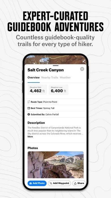
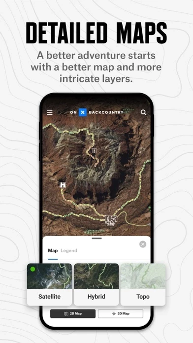
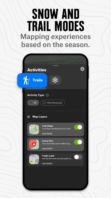
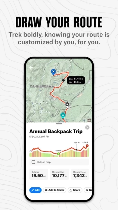
Explore the unknown with confidence using onX Backcountry, the all-in-one GPS navigation and guidebook app for skiers, snowboarders, hikers, backpackers, and backcountry adventurers of all kinds with over 650,000 miles of hiking trails, 24K topographic maps, and carefully curated guidebook content with over 450,000 points of interest, and even more campsites to guide you on your next outdoor adventure.
View public land boundaries, topographic maps, hiking trails, recreation sites, avalanche forecasts, slope angles, and more.
Captures d'écran officielles
onX Backcountry Hike Ski Map Forfaits tarifaires
| Durée | Montant (USD) |
|---|---|
| Abonnement annuel | $29.99 |
**Les données de tarification sont basées sur les prix d'abonnement moyens indiqués par les utilisateurs de Justuseapp.com..
Détails du produit et description de
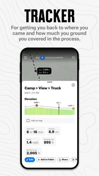
Spring is here, and the onX Backcountry App is your ultimate guide to discovering new adventures, knowing exactly where you are in the backcountry (even without cell service), and getting home safely after a day -- or a week! -- in the mountains. Brought to you by onX, the leader in outdoor-recreation mapping apps loved by millions of users, onX Backcountry provides the unique combination of guidebook-quality trail content and photos, always-available GPS location data, and an easy-to-use contextual mapping experience including 3D, distance and tracking tools, your photos on the map, and more. WHY USE A MAPPING APP? onX Backcountry turns your phone into a robust GPS navigation system and trail finder with real-time location tracking. View backcountry trails near you with photos and descriptions, explore 24K topographic and satellite maps, unlock a whole new season of hiking and backpacking adventure, find public land, check the 7-day weather forecast -- and for backcountry skiing and splitboarding, study avalanche forecasts and slope angles. Your outdoor adventure is up to you, onX Backcountry goes as far as you do. TAKE YOUR MAPS WITH YOU: OFFLINE GPS NAVIGATION Turn your phone into a powerful GPS navigation unit even when you’re off the grid. With onX Backcountry, save Offline Maps to be able to see your exact location on the map, even without cell service. Track your route while sliding on snow to always know where you are. FIND INSPIRATION: GUIDEBOOK FOR SKI TOURING & HIKING TRAILS Discover your next trails adventure by choosing from our industry-leading 650,000 mile network of trails, or try one of our 10,000+ Featured Adventures to see detailed trail information including photos, description, difficulty, distance, elevation, etc. Also explore 450,000 outdoor recreation “points of interest” and more than 54,000 campsites. It’s a digital guidebook and outdoor trip planner in your pocket! MAP YOUR MEMORIES: MARK WAYPOINTS WITH YOUR PHOTOS Add waypoints to the map to mark spots you loved, to remember where to explore next time, or to share with a friend. Make it a memory by adding photos. Customize your waypoints with icons for campsites, summits, lines, couloirs, cornice, skin tracks, water crossings, and more. 7-DAY FREE TRIAL While many onX Backcountry features are free, some features require a paid membership. We offer a 7-day free trial with access to all the features. No credit card required -- you decide when or if you’d like to purchase. If you choose not to buy, you’ll continue to have access to the free version of onX Backcountry app, including basic trail maps, weather, and Waypoints. ONX BACKCOUNTRY MEMBERSHIP onX Backcountry is available on an introductory offer of 25% off through 2021 -- $29.99 for the initial year and renewing at $39.99/year. With a Membership, you’ll unlock these top features: • Know where to go: Guidebook-quality trail & snow content, with photos and descriptions • Know where you are with unlimited Offline Maps for hiking trails, backpacking, and everything in between. • Explore maps in 3D, plus 24K topo and satellite maps • Discover and save your favorite hiking trails • Access 985M+ acres of public land, including US Forest Service, BLM, and State Land • Track real-time speed, distance, elevation, and duration of your hike with Tracker THE onX MISSION Our mission is to awaken the adventurer inside everyone. onX products are built by adventurers, for adventurers. Our appreciation for wild places drives us to preserve access to the recreation that we cherish. As a company, we invest in land access initiatives to expand and protect open spaces. Read more about our land access initiatives here: https://www.onxmaps.com/onx-access-initiatives FEEDBACK Want to request new features? Contact us at [email protected]