MotionX GPS Présentation
Continued use of any GPS service running in the background can significantly decrease battery life.
We listen to our users and continuously add the most requested features.
Captures d'écran officielles


Détails du produit et description de
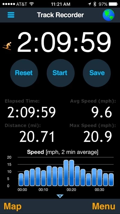
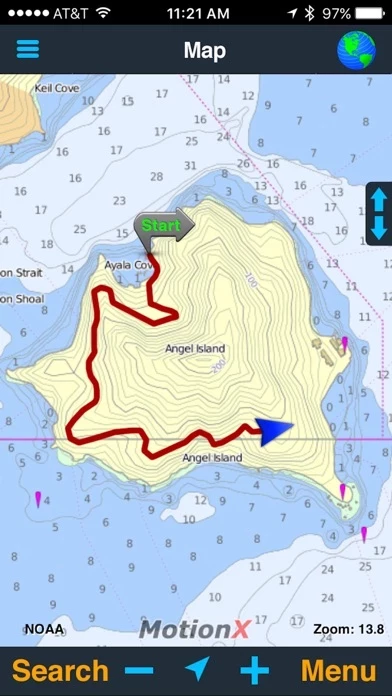
#1 About.com Winner: Best Outdoor App #1 iPhone app, Backpacker Magazine "Tremendous!" - ComputerWorld "The software you need!" - Navigadget "My favorite when I go hiking" - Washington Post "Favorite, hands down" - Mac Observer ・・・・・・・・・・・・・・・・・・・・・ ▶ The #1 multi-sport GPS app for the iPhone ▶ Great for hiking, biking, skiing, snowboarding, running, sailing, flying, navigating, geocaching, and more ▶ Over 5 million users, top rated around the world ▶ Most accurate iPhone GPS ▶ Best map selection: choose from 14 different sources including road, terrain, satellite, and marine map types ▶ Free map downloads worldwide! Including OpenStreetMap, terrain maps, and NOAA marine charts ▶ Unlimited map downloading for use offline ▶ Save up to 300 GPS tracks & 2500 waypoints ▶ Live Position Updates: optionally share your position automatically in real-time with others you choose ▶ Optimized for use with the Apple Watch ▶ Advanced interactive stopwatch with voice coaching ▶ Supports DMS, DM, D, MGRS, UTM, and OSGB grid systems ▶ Record GPS tracks and waypoints, follow saved or imported routes, import and export GPX files, display altitude, heading, compass, and much more ------------------------------------------------ Continued use of any GPS service running in the background can significantly decrease battery life. MotionX is committed to constant improvement. We listen to our users and continuously add the most requested features. Thank you for the feedback!
Haut Avis
Par clashdot
World wide !
Sur le territoire français, IPhiGéNie propose de meilleures cartes, normal ! Mais ailleurs, MotionX-GPS est irremplaçable : top !
Par Josselinb
La meilleure appli du genre
Avec la possibilité d'importer et d'exporter les traces et d'utiliser les cartes Google ou Apple ou open street map que l'on peut télécharger c'est la meilleure appli du genre. De plus elle consomme peu de batterie et permet d'envoyer sa position en temps réel si on souhaite. Mieux et plus stable qu’un garmin.
Par toukorek
La meilleure appli GPS que je connaisse
Beaucoup de fonctions, interface très intuitive, et surtout très économe en batterie (tient sans problème 5 h en utilisation avec un iPhone 7 pour peu que l’on n’utilise pas trop l’écran ) Pratique en VTT, trecking, bateau ... Les cartes fournies sont utiles mais avec possibilité de charger des cartes perso compatibles. J’aurais mis 6 étoiles si c’était possible!