Xavion Logiciel
Nom de la société: X-Avionics, LLC
À propos: Xavion provides an iPad-powered backup of your primary flight instruments.
Siège social: Columbia, South Carolina, United States.
Xavion Présentation
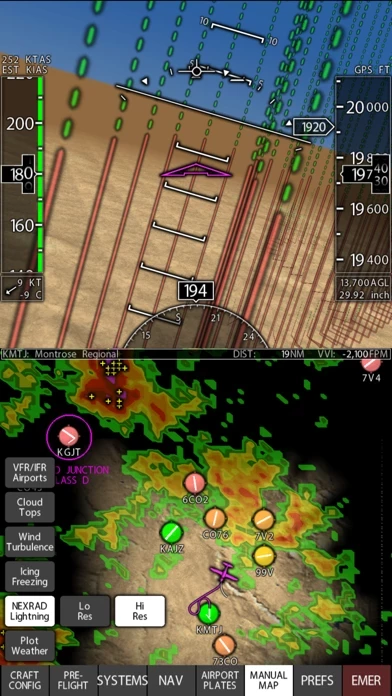
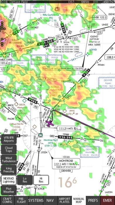
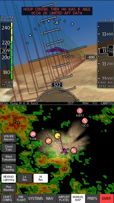
As well, Xavion tracks other airplanes via ADS-B, and memorizes their location to track their WAKE TURBULENCE, moving the wake turbulence down and with the wind over time, showing the wake turbulence as little spiraling tornados.
Also, Xavion checks your weight and balance, and even estimates your takeoff distance and compares that to the length of the runway that you are about to take off on to warn you if the available runway length from your current location is marginal for a safe take-off.
In flight, Xavion constantly imagines engine-failed glides to every runway in gliding range, and then shows you the safest-possible route as a Highway-In-The-Sky to take to an airport in the event of engine failure.
Also, Xavion estimates time and fuel burn at all different altitudes to any destination, showing you the time and fuel burn required for each altitude enroute, so you can pick the best altitude.
Captures d'écran officielles
Détails du produit et description de
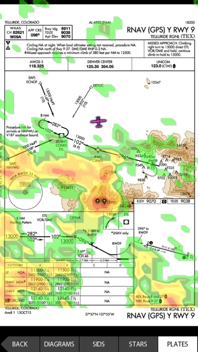
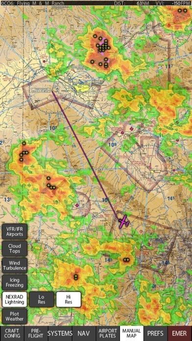
In flight, l’application constantly imagines engine-failed glides to every runway in gliding range, and then shows you the safest-possible route as a Highway-In-The-Sky to take to an airport in the event of engine failure. This, finally, gives you guidance after an engine failure that is based on energy-management all the way down, where the computer does the glide-planning for you… you just fly through the hoops to the runway. l’application also has instrument approaches in 3-D for the United States, so you can simply select any approach and then fly through the hoops to fly it! As well, l’application tracks other airplanes via ADS-B, and memorizes their location to track their WAKE TURBULENCE, moving the wake turbulence down and with the wind over time, showing the wake turbulence as little spiraling tornados. Finally, an App that tracks and shows you the wake turbulence of other airplanes. As well, l’application gets ADS-B weather if you have a portable receiver, and displays it, including the new icing, turbulence, and lightning products. l’application also gets METARS and winds aloft from the internet if you have a WIFI or cell signal to help you plan before a flight! Also, l’application checks your weight and balance, and even estimates your takeoff distance and compares that to the length of the runway that you are about to take off on to warn you if the available runway length from your current location is marginal for a safe take-off. Also, l’application estimates time and fuel burn at all different altitudes to any destination, showing you the time and fuel burn required for each altitude enroute, so you can pick the best altitude. l’application, and l’application alone in the sky, gives engine-failure guidance and wake-turbulence avoidance. All USA VFR and IFR charts and plates are included with base subscription. Terms of use and Privacy Policy can be found at: http://l’application.com/l’application-privacy-policy-and-terms-of-service/ Continued use of GPS running in the background can dramatically decrease battery life.
Haut Avis
Par Angelinair
XAVION
Une application excellente ! Gage de sécurité en vol VFR ou IFR Instrument de secours en cas de panne électrique en vol .
Par Slasherbro'
Excellente application !
Excellente application ! Excellente approche, orientée terrain, et qui a déjà fait ses preuves avec par exemple des utilisateurs qui avaient perdu en conditions IFR tous leurs affichages primaires et ont pu atteindre un terrain de façon plus sereine grâce à l’application.
Par Flyelixir
Excellent
Absolute awesome idea, can be used in x-plane as a training EFIS or in a real plane to feel more safe in case we need a path to follow, I would add a "lock" runway cause sometime it jump from an approach to another at final. Keep the good work.