Xavion Software
Company Name: X-Avionics, LLC
About: Xavion provides an iPad-powered backup of your primary flight instruments.
Headquarters: Columbia, South Carolina, United States.
Xavion Overview
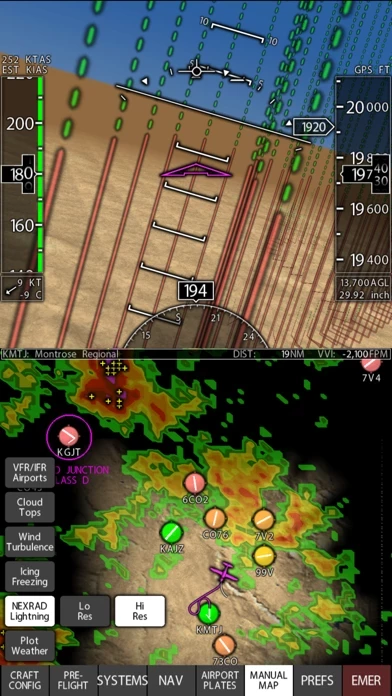
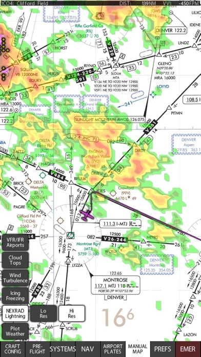
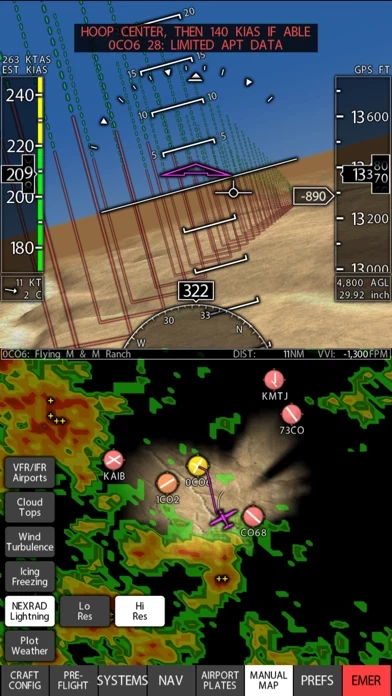
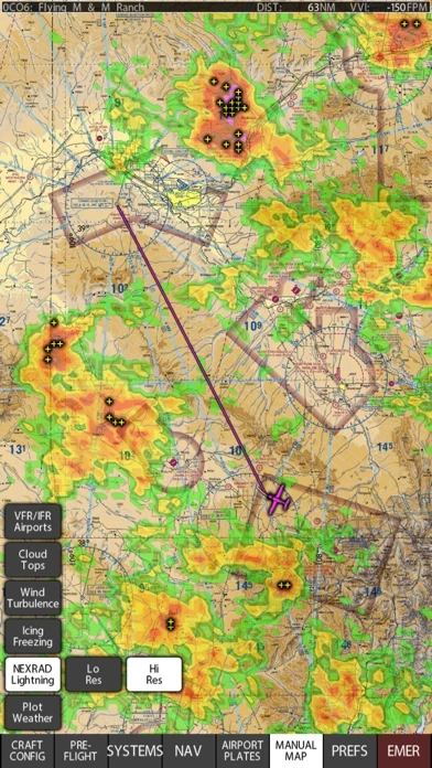
As well, Xavion tracks other airplanes via ADS-B, and memorizes their location to track their WAKE TURBULENCE, moving the wake turbulence down and with the wind over time, showing the wake turbulence as little spiraling tornados.
Also, Xavion checks your weight and balance, and even estimates your takeoff distance and compares that to the length of the runway that you are about to take off on to warn you if the available runway length from your current location is marginal for a safe take-off.
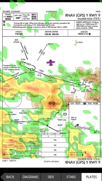
In flight, Xavion constantly imagines engine-failed glides to every runway in gliding range, and then shows you the safest-possible route as a Highway-In-The-Sky to take to an airport in the event of engine failure.
Also, Xavion estimates time and fuel burn at all different altitudes to any destination, showing you the time and fuel burn required for each altitude enroute, so you can pick the best altitude.
Official Screenshots
Product Details and Description of
In flight, this app constantly imagines engine-failed glides to every runway in gliding range, and then shows you the safest-possible route as a Highway-In-The-Sky to take to an airport in the event of engine failure. This, finally, gives you guidance after an engine failure that is based on energy-management all the way down, where the computer does the glide-planning for you… you just fly through the hoops to the runway. this app also has instrument approaches in 3-D for the United States, so you can simply select any approach and then fly through the hoops to fly it! As well, this app tracks other airplanes via ADS-B, and memorizes their location to track their WAKE TURBULENCE, moving the wake turbulence down and with the wind over time, showing the wake turbulence as little spiraling tornados. Finally, an App that tracks and shows you the wake turbulence of other airplanes. As well, this app gets ADS-B weather if you have a portable receiver, and displays it, including the new icing, turbulence, and lightning products. this app also gets METARS and winds aloft from the internet if you have a WIFI or cell signal to help you plan before a flight! Also, this app checks your weight and balance, and even estimates your takeoff distance and compares that to the length of the runway that you are about to take off on to warn you if the available runway length from your current location is marginal for a safe take-off. Also, this app estimates time and fuel burn at all different altitudes to any destination, showing you the time and fuel burn required for each altitude enroute, so you can pick the best altitude. this app, and this app alone in the sky, gives engine-failure guidance and wake-turbulence avoidance. All USA VFR and IFR charts and plates are included with base subscription. Terms of use and Privacy Policy can be found at: http://this app.com/this app-privacy-policy-and-terms-of-service/ Continued use of GPS running in the background can dramatically decrease battery life.
Top Reviews
By Motorglider
Life-saving tool
Excellent situation awareness, terrain avoidance and emergency landing guidance. this app works on an iPhone as well as it does on an iPad. I mount it next to my undersized cockpit console, and have complete panel back up in case of electrical failure. I use earbuds underneath my headset for audible terrain avoidance alerts. When I get ADS-B, I will also enjoy traffic alerts. this app works seamlessly with X-Plane for flight planning and proficiency simulation. With Seattle Avionics subscriptions (additional) do you have moving me up display on VFR Sectional, IFR Enroute charts and Approach Plates. All I would ask in addition to these features is a one touch transition between approach plates and Highway-in-the-sky guidance to the threshold.
By BruceK35
Fantastic SA with the additional the Flight Director
With the addition of the Flight Director capability I have truly fallen in love with this app. I have it connected to my Stratux box and it is AMAZING how accurate it is to my actual altitude and airspeed. I’m still dialing in on how best to use the flight director capabilities but having it up and running all time and then able to hit the emergency button if something happens to give you guidance to the nearest airport is incredible. Also having additional 3D reference to approaches and the missed procedure is unprecedented in an iPad app. Looking forward to future improvements as the app is always getting better.
By Cheroke180
Xavion Top Rated
I have used this app for 3 years now and I believe it’s one of the best aviation apps to give you a sense of security while in a single engine airplane flying day or night as it continuously looks for airports you could glide to based on your aircrafts glide characteristics. All you have to do is fly the highway-in-the-sky hoops! I have it turned on with every flight on a separate iPad. In addition, it can be used with X-Plane to practice engine out emergencies as well as in the actual aircraft. Regards, Don