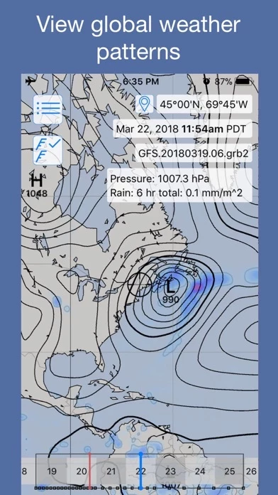
LuckGrib Übersicht
For meteorologists, and weather enthusiasts, LuckGrib offers access to a wide range of high resolutions models, a number of global models, weather data at the surface, 850mb, 500mb and 250mb levels, parameters ranging from simple things such as wind, pressure and temperature, to more advanced quantities such as simulated radar, standard deviations, precipitable water, lightning, vertical vorticity, helicity and more.
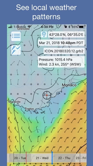
For offshore sailors, LuckGrib offers a best-in-class, complete solution: industry leading visualization and ease of use, highly optimized weather data downloads via satellite, along with industry leading optimized weather routing and route analysis.
LuckGrib provides access to many weather and ocean models, including: GFS, GFS Wave, GDPS/GEM, GEFS, HRRR, RAP, NAM, NBM, Icon-EU, Arpège, Arome, OpenWRF, RTOFS, NCOM and many others.
Offizielle Bildschirmfotos
Produkt einzelheiten und Beschreibung von
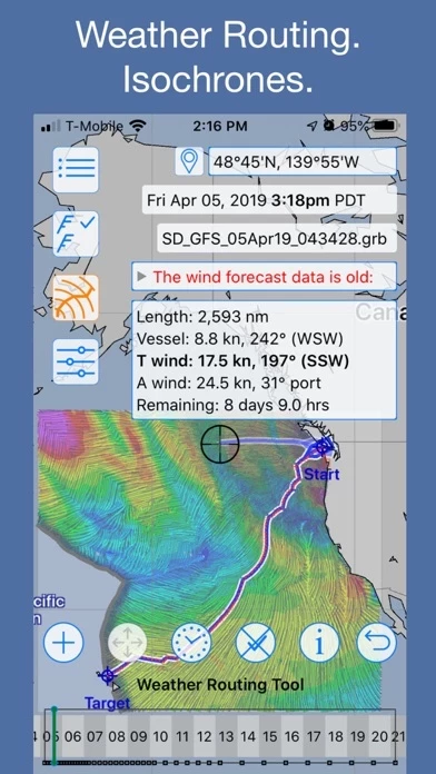
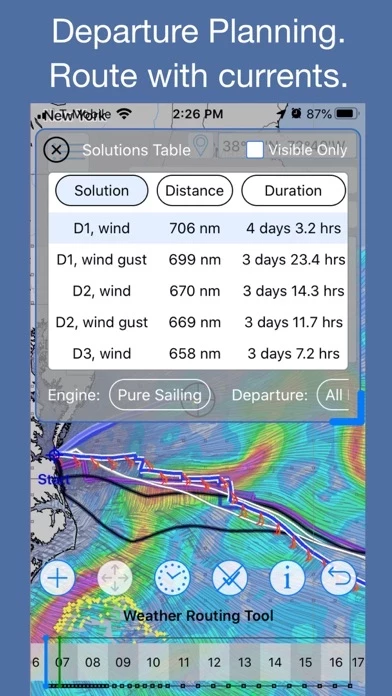
diese App is a fully featured, easy to use, fast GRIB reader, viewer, downloader and weather router. Remote access to weather data via satellite or email is supported. Advanced weather routing capabilities, for sailors, is available. Weather forecast data, packaged as GRIB files, can be downloaded directly from the diese App server cluster. For offshore sailors, diese App offers a best-in-class, complete solution: industry leading visualization and ease of use, highly optimized weather data downloads via satellite, along with industry leading optimized weather routing and route analysis. Inshore sailors may not require satellite downloads, but will benefit from the rest of the system. diese App is unique among apps that were originally designed for sailors, in that the weather analysis tools are powerful enough to attract attention from meteorologitsts. For meteorologists, and weather enthusiasts, diese App offers access to a wide range of high resolutions models, a number of global models, weather data at the surface, 850mb, 500mb and 250mb levels, parameters ranging from simple things such as wind, pressure and temperature, to more advanced quantities such as simulated radar, standard deviations, precipitable water, lightning, vertical vorticity, helicity and more. Access is available to the entire suite of parameters in GFS, HRRR, NAM and others. Downloads are available via: a direct high speed internet connection, through the Iridium GO! as well as through the RedPort Optimizer. diese App provides access to many weather and ocean models, including: GFS, GFS Wave, GDPS/GEM, GEFS, HRRR, RAP, NAM, NBM, Icon-EU, Arpège, Arome, OpenWRF, RTOFS, NCOM and many others. These models allow you to study surface conditions, wave and swell state, ocean currents, winds at the jet stream level, mid atmosphere as well as at the boundary layer. In addition, diese App allows you to explore weather model uncertainty with its support for standard deviation and probability values. diese App is a thoroughly modern and advanced GRIB viewer. See: diese App.com/models for more details on the models and parameters that are available. diese App comes with a 14 day free trial. If you are interested in studying weather and gaining access to detailed weather forecasts, download the app and give it a try. Downloading data via satellite or email requires the Offshore Data in-app purchase. See offshore.diese App.com for more details on the remote access capabilities. The diese App weather routing system is an industry leading, high quality, robust, high performance and comprehensive system. See routing.diese App.com for more details. Access to the isochronal weather routing system requires an in-app purchase. The diese App isochronal Weather Routing solver is able to respect intermediate constraint points, the first in the industry. A constraint point is a point which a route must leave to port or starboard. Constraint points are needed to describe short routes which have crossings, as well as to express your preference on a long open ocean passage to stay to a given side of a strategic point. A simple example of a short route that needs this ability is a route which goes around an island, returning to the start point. Many sailboat race routes, perhaps the majority, have routes which cross. Two examples are Fastnet and the Around Catalina Island race. These routes can now be described in diese App, and optimized Weather Routing solutions found for them. Note that diese App does not use a subscription pricing model - after the free trial, when you decide to purchase the app, there will be a one time charge, not an ongoing subscription. For more details, please visit the support website. * privacy policy: https://diese App.com/privacy * terms of use: https://diese App.com/terms-of-use * end user license agreement: https://www.apple.com/legal/internet-services/itunes/dev/stdeula/
Oben Erfahrungen und Bewertung
durch NF25899
Sehr gute App für Wetterfreaks
Diese App stellt Grib-Dateien unterschiedlicher Wettermodelle grafisch und als Meteogramm dar. Der Kaufpreis geht in Ordnung angesichts der hervorragenden grafischen Darstellung und wegen der Vielzahl der kostenlos ladbaren Modelle (nicht nur GFS, auch Icon, Cosmo, Arpege, Arome u.a.) und Parameter für Wetter und noch zahlreiche weitere Modelle für Wind und Wellen. Ab sofort meine bevorzugte Wetter-App :-)
durch prg18
Sehr genau und kann man Gribdaten vergleichen
Intelligente und einfache Software
durch Wolf011
Super
Nur vom Feinsten.