700 City Maps Présentation
We have all the major cities and tourist destinations like Paris, Rome, London, New York, Amsterdam, Bali, Hong Kong, Jakarta, Tokyo, Sydney, Venice, Barcelona, Malta, and many others, up to and including small places like Aix-en-Provence, Allentown Pennsylvania, Williamsburg Virginia, Surfers Paradise, and national parks like Yellowstone, Shenandoah, and many others.
The mobile streetmaps are for you! All the map data is loaded on your iPhone or iPad before you leave your home, so can you be on the streets, offline, and still know everything about the area you are in, and locate yourself or any street in the city.
All the data for each map is stored on your iPhone or iPad, so it works where you have no access to the Internet - it works where Google Maps is inaccessible.
This prevents expensive data roaming charges by loading all the map data to your iPhone or iPad before you leave home.
Captures d'écran officielles


Détails du produit et description de
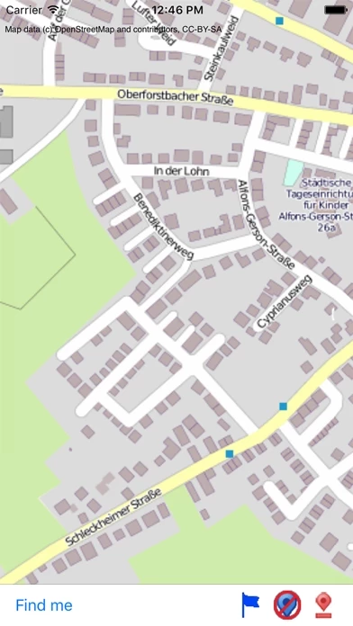
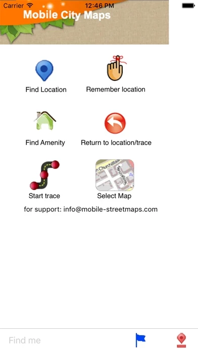
700 City Maps for you to choose from! Do you feel online Google Maps is too slow showing you the map? Do you want an easy way to mark and remember where you are? Do you need a list of streets where you are? You don’t want to carry around a big unwieldy paper map? Tired of having the paper map blown to pieces by the wind every time you try to figure out where you are and where you need to go? The mobile streetmaps are for you! All the map data is loaded on your iPhone or iPad before you leave your home, so can you be on the streets, offline, and still know everything about the area you are in, and locate yourself or any street in the city. You don’t need any network connection at all once the application is installed on your iPhone – no WiFi, no 3G, no GPRS! You can choose from more than 700 maps to download. All the data for each map is stored on your iPhone or iPad, so it works where you have no access to the Internet - it works where Google Maps is inaccessible. This prevents expensive data roaming charges by loading all the map data to your iPhone or iPad before you leave home. You can turn off all network functions and still be able to find your way around. Lets you find all streets, and many useful locations such as ATM's, parkings, museums, and many others. Remembers where you've been so you can find that parking spot where you left your rental car, or that great restaurant. Allows you to mark interesting locations to visit in advance. To make sure your phone doesn't use any expensive data on your trip, go to Settings, then General, tap on Network, and slide the Data Roaming to "off". Note: GPS functions work on the iPhone iPad 3G only, the iPod and WiFi iPad use "assisted GPS" based on nearby WiFi networks, and often know roughly where you are, but they are not as precise as GPS equipped iPhones and iPads. We have all the major cities and tourist destinations like Paris, Rome, London, New York, Amsterdam, Bali, Hong Kong, Jakarta, Tokyo, Sydney, Venice, Barcelona, Malta, and many others, up to and including small places like Aix-en-Provence, Allentown Pennsylvania, Williamsburg Virginia, Surfers Paradise, and national parks like Yellowstone, Shenandoah, and many others. We're constantly expanding the list, and if we currently don't have the one you're looking for, tell us! For a full list of available maps, please visit our website! Please note: Continued use of GPS running in the background can dramatically decrease battery life. Map data (c) OpenStreetMap and contributors, CC-BY-SA.
Haut Avis
Par Maurice Churlet
Bien
Moins cher que la carte papier et avec des fonctions d'enregistrement et de localisation gps. Excellent pour les randos dans des pays inconnus. Chargé Nouméa et Sydney. Une aide explicative serait la bien venue. Carte assez longue à charger mais très détaillées. Dois-je repayer pour l'iPad si je l'ai acheté pour l'iPhone ?
Par Lirea
Peut mieux faire
Les rues apparaissent toutes, semble t-il, et contrairement à certaines apps. Leur nom, en zoom maximum, est lisible. la possibilité de faire apparaître en gros le nom des stations de métro et autres est un plus - bien qu'un peu rustiquement réalisé. Le plan du métro est clair, aussi, sans problème. Mais si vous cherchez une station, une rue, ne comptez que sur vos yeux ! pas de fonction de recherche alors que des appli gratuites - comme Guide Paris ou encore Le Metro - vous offre gratuitement des fonctions autrement avancées. Qui offrira enfin une app complète ?
Par Toutoune99
Nul !
Faut gratuit, c'est vrai. Il faut payer 2.39 € pour avoir chaque plan de ville. Avec700 villes ça pourrait rapporer ! J'ai acheté le plan de Kyoto. Non, ce n'est pas une arnaque : le plan n'est n'est pas moins détaillé que sur la capture d'écran ci dessus... mais à peine plus. Il manque énormément de rues. Les rues ne sont pas moins signalées que sur la capture d'écran... mais pas plus, il y a très peu de noms de rues et même pas compréhensibles. Une arnaque non, surtout si on a 2.39 € à jeter :(