WWF Nautical Chart Avis
Publié par WWF Deutschland on 2024-07-30🏷️ À propos: The app can be used to locate one's own position on the Greifswald Bodden and Strelasund. At the same time, the protected zones within the Natura 2000 area are displayed.

🏷️ À propos: The app can be used to locate one's own position on the Greifswald Bodden and Strelasund. At the same time, the protected zones within the Natura 2000 area are displayed.
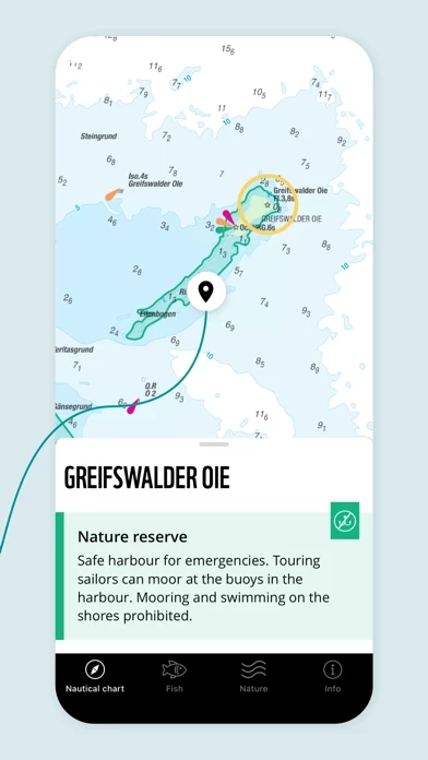

The improved orientation on the water is intended to reduce DISTURBANCES in the protected bays, the Natura 2000 core zones, so that people and nature can use the species-rich Bodden waters in harmony.
- Coloured areas à information about the protected areas (including nature conservation areas and fish sanctuaries) appear.
Thus, Bodden users, e.g. anglers, sailors, kiters, rowers, paddlers or canoeists, can check on their smartphone or tablet at any time where they are currently located and whether they are inside or outside protected areas.
The argument of not knowing where the border is no longer counts! This makes it possible for everyone to easily comply with the "Voluntary Agreement on Nature Conservation, Water Sports and Fishing in the Greifswald Bodden and Strelasund" on the water.
In the "Fish" section you will find useful information on angling, including the way of life, fishing times, minimum sizes and closed seasons of the individual species.