RunwayMap - #1 Pilot Community Avis

RunwayMap Avis

Publié par on 2025-02-17

🏷️ À propos: The interactive map gives you an overview of the airports. We have collected important information on every airport: • Aviation Weather Forecasts • 3D Approach View and 3D Airport Surroundings View • NOTAM and Runways • Airport Restaurants • Webcams and much more Download the versatile pilot app while you are at it.


Expérience client globale 😎


😎 Positif
42.2%

🤬 Négatif
33.4%

🫥 Neutre
24.5%

~ à partir de Justuseapp.com NLP'analyse de 9 revues de logiciels combinées.


Lire 0 Service client avis 😠💢

4.6 out of 5


Est RunwayMap Sûr? 🙏

Oui. RunwayMap - #1 Pilot Community est très sûr à utiliser. Ceci est basé sur notre analyse NLP (Traitement du langage naturel) de plus de 9 avis d'utilisateurs provenant de l'Appstore et la note cumulative de l"Aappstore de 4.6/5 . Score de sécurité Justuseapp pour RunwayMap Est 55.8/100.


Est RunwayMap Légitime? 💯

Oui. RunwayMap - #1 Pilot Community est une application totalement légitime. Cette conclusion a été obtenue en passant 9 RunwayMap - #1 Pilot Community avis d'utilisateurs via notre processus d'apprentissage automatique NLP pour déterminer si les utilisateurs croient que l'application est légitime ou non. Sur cette base, Justuseapp Score de légitimité pour RunwayMap Est 88.2/100..


Paiement 💸

**Les données de tarification sont basées sur les prix d'abonnement moyens indiqués par les utilisateurs de Justuseapp.com..

Forfaits tarifaires Montant (USD)
3D PLUS $2.99
3D PLUS $14.99
Aviation Weather PLUS $12.99
Tools PLUS $2.49
Tools PLUS $12.99
Aviation Weather PLUS $2.49
Aviation Weather PRO $3.99
Aviation Weather PRO $24.99
VFR Switzerland Map $12.99
VFR France WE Map $24.99


Quelle a été votre expérience avec RunwayMap - #1 Pilot Community ? Poster un avis


Caractéristiques

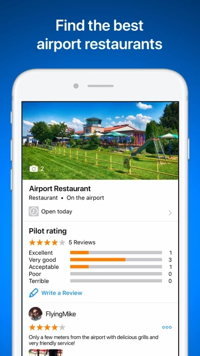
Where can you call in an order over the radio while you’re still up in the air? Which airport restaurant has a great sun deck with a view of the runway? In RunwayMap, you’ll find restaurants at and near airports.

With just a few clicks, add your flight documents, such as the Jeppesen approach charts, FAA terminal procedures and airport diagrams, ForeFlight manuals or the Garmin pilot’s guide.

Your subscription will be automatically renewed (another month for monthly subscribers, another year for annual subscribers) if you do not cancel it at least 24 hours before expiry of the current term.

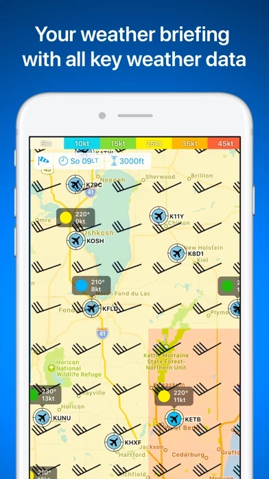
In addition, you can see the decoded METAR with wind, clouds, gusts, and visibility on the airport's detail page.

Based on the wind data from METAR or the forecast, the best runway for landing and the crosswind component will be displayed for the desired time.

  Contacter le support
Développeur:
RedDev GmbH

Courriel de contact:

WebSite:

Politique de confidentialité: