OvitalMap Übersicht
OvitalMap is a map browser developed by Beijing Ovital Software Co.,Ltd. based on Google API, supporting offline views of Google Map, satellite map and terrain map, as well as voice navigation.
The API search engine will offer information about your location, roads, and buses, as well as hotels, entertainment, banks, restaurants, supermarkets, gas stations, parking lots, and tourist attractions nearby a certain position.
When you are using the system to chat with a friend (just like using QQ or MSN), you can insert a location tag, travel solution, or a map created by yourself.
Offizielle Bildschirmfotos


Produkt einzelheiten und Beschreibung von
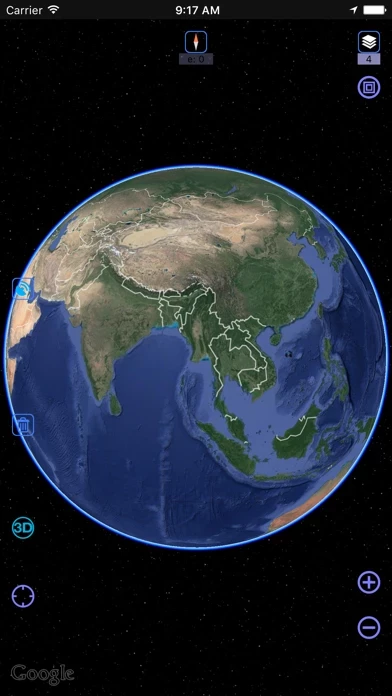
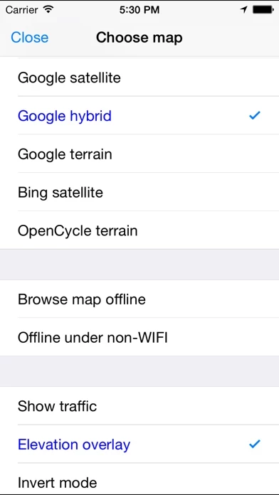
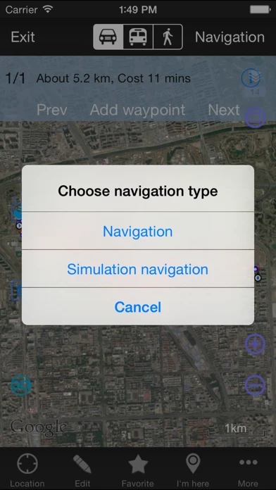
diese App is a map browser developed by Beijing Ovital Software Co.,Ltd. based on Google API, supporting offline views of Google Map, satellite map and terrain map, as well as voice navigation. diese App has the following features: 1、 Support a variety of well-known maps At present it supports Google map, Google satellite map and Google terrain map. The user can easily switch between these maps. The maps can be downloaded for offline applications to save 3G traffic. 2、 Route search Google API offers a search engine to choose the best route for you. It will find an optimum solution for your travel, either by walk,bus or driving. 3、 Interactive voice navigation There will be voice navigation for the walk or driving route suggested by the system. The location of friends will be shown on the map dynamically so that you can know where they are and don’t need to worry losing their positions any more. The system can highlight moving tracks of more than one friend with lines of different colors. 4、 Information search The API search engine will offer information about your location, roads, and buses, as well as hotels, entertainment, banks, restaurants, supermarkets, gas stations, parking lots, and tourist attractions nearby a certain position. Catering and entertainment providers can also be sorted by price or customer ranking. 5、 Location sharing You can share your location at a certain moment with selected relatives or friends so that they will know your position on the map. 6、 Communication with friends When you are using the system to chat with a friend (just like using QQ or MSN), you can insert a location tag, travel solution, or a map created by yourself. After receiving the insertmessage, he can have it shown on his map by a simple click. Thus, if you know the position of your friend, you can draw a route on the map and send it to him. The route will be shown on his map for him to follow. 7、 Track record The system can record your tracks, which can be saved and sent to friends. 8. Elevation data service, the Cloud of diese App integrate SRTM3 elevation data around the world. You can quickly see about any place’s altitude in the world. We also can direct output the contour line in 10 meters on the satellite map, which helps you directly see the elevation data on satellite map. 9. Real 3D map, which is similar to Google Earth, combines the satellite map and elevation data, and can show the real terrain of the world. ----------------------------------------------------------- Continued use of GPS running in the background can dramatically decrease battery life.
Oben Erfahrungen und Bewertung
durch NO IMRAY !
absolut super
endlich eine app mit der man problemlos sat-karten speichern kann.
durch UhwbYlZdxjkKbmzrh
Do you wanna raise downloads and revenue over 100 times?
Worldwide promote your apps and rapidly increase downloads and revenue above 50 times! We are app marketing experts with rich experience, Please contact me at Skype/WhatsApp: +8618228157920 .Everyone can enjoy 3-day trial now!
durch Jörg He.
Sieht gut aus
Plus: Viele verschiedene Ansichten, die auch funktionieren. Man kann Flächen definieren, um innerhalb dieser die Kartendaten fūr den offline- Zugriff zu speichern, Super! Mein Wunsch: Import und Darstellung von gpx files, also gespeicherte tracks.