SkyDemon Übersicht
SkyDemon is Europe's favourite software for VFR flight planning and in-flight navigation.
Use this app to access your SkyDemon subscription on your iOS device, unlocking SkyDemon's powerful features while on the move.
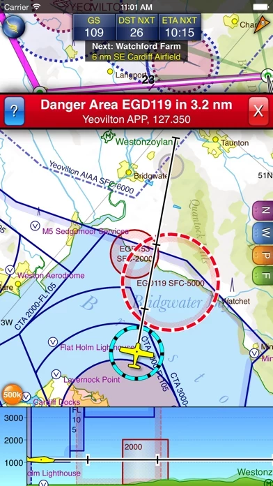
Offizielle Bildschirmfotos
Produkt einzelheiten und Beschreibung von
diese App is Europe's favourite software for VFR flight planning and in-flight navigation. Use this app to access your diese App subscription on your iOS device, unlocking diese App's powerful features while on the move. FLIGHT PLANNING FEATURES - diese App vector charts are the clearest aeronautical charts you'll ever use, with dynamic airspace clipping and choice of map layers - Route planning is as simple as touching consecutive waypoints and dragging to make changes - Virtual Radar shows how your route relates to airspace, terrain, obstructions and other features - Pilot Log facility calculates headings and groundspeeds from actual wind data, and shows useful frequencies - Plates and other documents for relevant airfields are displayed automatically as you plan, and many are available georeferenced for use in flight - Intuitive pan, pinch and rotate support with no loss of map clarity or text legibility - File a VFR flightplan for your route directly to air traffic controllers - Automatic TAF, METAR and SIGMET briefing as you plan a route, with graphical decoding - Rainfall data can be overlaid on the main map, with animation, showing the trend of rainfall over time - Integration of GAFOR route forecasts for Switzerland, Austria, Slovenia and Croatia - Both narrow-route and area NOTAM briefings available, updated as you plan - Advanced NOTAM graphical interpretation and depiction on the main map - Easily print your PLOG and the output from various briefings - Warnings for airspace and other potential hazards to your flight, updated in real time - Airfield Admin Information shows useful contacts and other details for airfields featured in our charts - Forecast winds aloft are automatically retrieved for the flight time and displayed on the map - Create an advanced flight performance profile for each aircraft you use - ATS Routes mode offers an alternative chart presentation for flight along airways - Accurate fuel, weight and balance calculations including flight costings - Create an unlimited number of user-defined waypoints - Analyse your track logs for posterity - Choose between six different vector chart styles - Extensive European chart coverage as standard GPS NAVIGATION FEATURES - Intelligent warnings for approaching airspace, NOTAM, obstacles, terrain and other hazards - Virtual Radar shows a side-on projection of all approaching features and how your trajectory relates to them - Vector map automatically follows the aircraft in north up, track up or course up orientation - Clear and concise instruments show you flight statistics and help keep you on track - An HSI/ILS instrument helps you keep to your planned route and line up early for approach - Live Pilot Log shows progress through your route, ETAs, ATAs and useful frequencies based on your current position - TerrainSafe dynamically colours mountainous terrain around you to quickly identify safer areas - Direct To allows easy re-routing in a hurry by picking from a selection of nearby airfields - Approach Information shows runway diagrams, TAF, METAR, NOTAM and other airfield details useful for making an approach - Live updates of TAF and METAR while in flight, with associated alerts* - Extended runway centrelines appear automatically on the map as you near your destination airfield - Permanent display of position relative to nearest well-known waypoint, for position reporting - Easy changing of the planned route while in flight by touching and dragging Continued use of GPS running in the background can dramatically decrease battery life. * Internet connection required for live weather update while in flight
Oben Erfahrungen und Bewertung
durch Lucky0107
Überzeugend
Sehr gute App, Support reagiert schnell und hilft bis zu Lösung.
durch ehl68
Beste App zum Fliegen
Ich habe in den letzten Jahren praktisch alle Apps zur Navigation probiert. Für mich ist diese App die vollständigste und einfachste App auf dem Markt. Planung am PC und Nutzung im Flug auf den iPad. Kurz Mal Wetter und Notams auf dem Telefon genau wie W&B alles kein Problem
durch D-ERAD
SkyDemon, für mich die Nr. 1
Alle hier aufgeführten 5-Sternebewertungen sprechen mir als E-Klasse VFR-Flieger aus dem Herzen! Vor allem die Karte, mit der man sich stufenlos von jedem großen Maßstab über die Platzrunde, Landebahn und Rollwege bis zum Hangar hineinzoomen kann. Als Mitte 2019 Jeppesens FiteDeck VFR abgekünigt wurde suchte ich eine neue App. ForeFlight wurde von Jeppesen als nachfolge App empfohlen. Ausprobiert: 4 Wochen Flugpause und ich musste mich fast wieder neu in die App einarbeiten. Unter Druck im Cokpit etwas umplanen zu müssen will ich mir nicht vorstellen. Mein Fazit: Viele, viele Funktionen, kompliziert zu bedienen. Für wirklich Vielflieger geeignet. Garmin Pilot Die App ist in der Bedienung sehr ähnlich aufgebaut wie mein Handheld, das aera 795, das ich im Cokpit eingebaut habe. Ebenfalls sehr umständlich zu bedienen, gerade bei kurzfristig erforderlichem umplanen. Das will ich gerade nicht mehr. Flymap, Sky-Map usw. mit ihren Rasterkarten kommen für mich nicht mehr in Frage; man zoomt sich rein und bekommt doch nicht mehr Informationen. 5 Sterne für diese App ist für mich ohne Übertreibung noch einer zu wenig!