SkyDemon Présentation
SkyDemon is Europe's favourite software for VFR flight planning and in-flight navigation.
Use this app to access your SkyDemon subscription on your iOS device, unlocking SkyDemon's powerful features while on the move.
Captures d'écran officielles
Détails du produit et description de
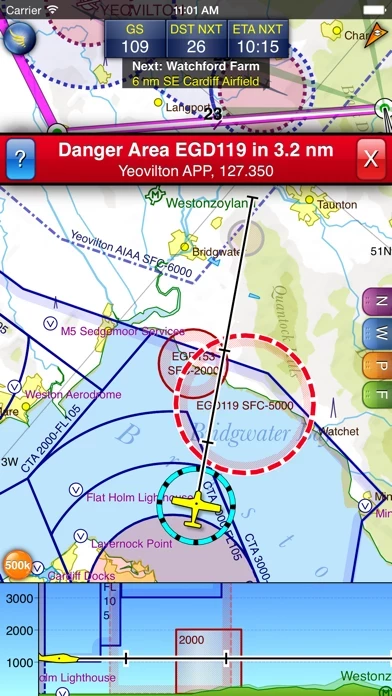
l’application is Europe's favourite software for VFR flight planning and in-flight navigation. Use this app to access your l’application subscription on your iOS device, unlocking l’application's powerful features while on the move. FLIGHT PLANNING FEATURES - l’application vector charts are the clearest aeronautical charts you'll ever use, with dynamic airspace clipping and choice of map layers - Route planning is as simple as touching consecutive waypoints and dragging to make changes - Virtual Radar shows how your route relates to airspace, terrain, obstructions and other features - Pilot Log facility calculates headings and groundspeeds from actual wind data, and shows useful frequencies - Plates and other documents for relevant airfields are displayed automatically as you plan, and many are available georeferenced for use in flight - Intuitive pan, pinch and rotate support with no loss of map clarity or text legibility - File a VFR flightplan for your route directly to air traffic controllers - Automatic TAF, METAR and SIGMET briefing as you plan a route, with graphical decoding - Rainfall data can be overlaid on the main map, with animation, showing the trend of rainfall over time - Integration of GAFOR route forecasts for Switzerland, Austria, Slovenia and Croatia - Both narrow-route and area NOTAM briefings available, updated as you plan - Advanced NOTAM graphical interpretation and depiction on the main map - Easily print your PLOG and the output from various briefings - Warnings for airspace and other potential hazards to your flight, updated in real time - Airfield Admin Information shows useful contacts and other details for airfields featured in our charts - Forecast winds aloft are automatically retrieved for the flight time and displayed on the map - Create an advanced flight performance profile for each aircraft you use - ATS Routes mode offers an alternative chart presentation for flight along airways - Accurate fuel, weight and balance calculations including flight costings - Create an unlimited number of user-defined waypoints - Analyse your track logs for posterity - Choose between six different vector chart styles - Extensive European chart coverage as standard GPS NAVIGATION FEATURES - Intelligent warnings for approaching airspace, NOTAM, obstacles, terrain and other hazards - Virtual Radar shows a side-on projection of all approaching features and how your trajectory relates to them - Vector map automatically follows the aircraft in north up, track up or course up orientation - Clear and concise instruments show you flight statistics and help keep you on track - An HSI/ILS instrument helps you keep to your planned route and line up early for approach - Live Pilot Log shows progress through your route, ETAs, ATAs and useful frequencies based on your current position - TerrainSafe dynamically colours mountainous terrain around you to quickly identify safer areas - Direct To allows easy re-routing in a hurry by picking from a selection of nearby airfields - Approach Information shows runway diagrams, TAF, METAR, NOTAM and other airfield details useful for making an approach - Live updates of TAF and METAR while in flight, with associated alerts* - Extended runway centrelines appear automatically on the map as you near your destination airfield - Permanent display of position relative to nearest well-known waypoint, for position reporting - Easy changing of the planned route while in flight by touching and dragging Continued use of GPS running in the background can dramatically decrease battery life. * Internet connection required for live weather update while in flight
Haut Avis
Par Thiev
Je ne connais rien de mieux
Très intuitive et régulièrement mise à jour au niveau des zones, cette appli est très pratique et complète. Un effort de traduction intégrale en français serait parfait notamment pour les explications des ajouts de nouvelles version. Les cartes vectorielles permettent de lire les étiquettes et les villes quel que soit l’orientation choisie. Les fréquences des zones à traverser ou proches sont affichées, la preparation de navs est hyper rapide et facile etc... Tous les pilotes devraient au moins essayer la démo gratuite d’un mois pour apprécier le travail de cette équipe très pro.
Par jepilbc37
Questions?
Bonjour 1°)Je n’ai pas trouver le moyen directement sur la carte de visualiser le tour de piste d’un Ad sans aller sur la carte VAC 2°)est-y-il possible de lire la dérive et le temps corrige sur la route en fonction du cap, en temps réel ? Merci de vos réponses Jpl
Par Jph 55
Langage
Il serait agréable d’avoir aussi un langage en français sur le PC comme sur l’iPad Merci