TZ iBoat Übersicht
The unmatched usability of its interface is what makes TZ iBoat absolutely essential! Its extremely intuitive features and its powerful 3D chart engine allow you to browse, rotate and zoom into your marine charts with incredible smoothness.
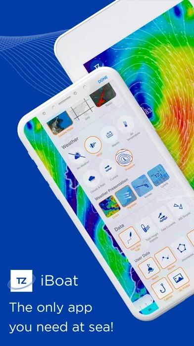
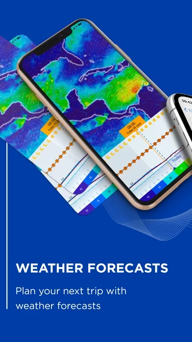
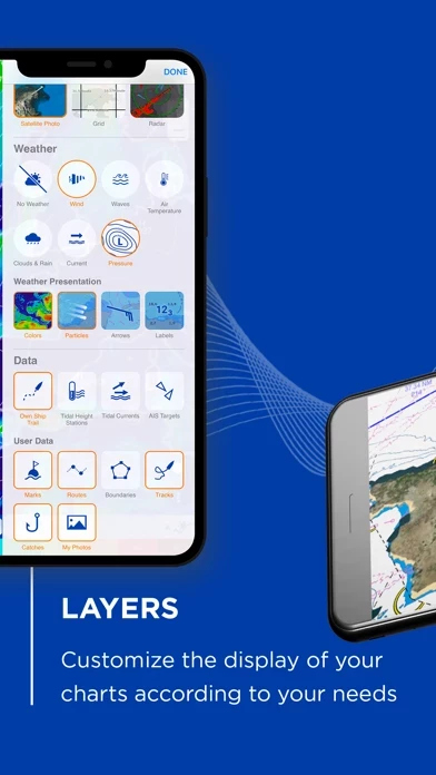
- Advanced weather display: in color, with animated particles, arrows or with labels to visualize wind, wave, current, pressure, cloud and precipitation.
- New Premium Weather subscription gain access to 5 high resolution models: Arpège, Arome, DWD ICON, NAM Conus and Copernicus with worldwide coverage.
Offizielle Bildschirmfotos
Produkt einzelheiten und Beschreibung von
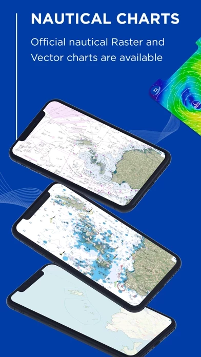
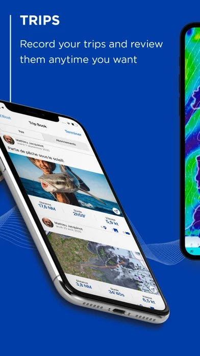
DISCOVER THE ONLY APP YOU NEED AT SEA! TZ iBoat is the most advanced boat navigation app on the market, it gathers all the features necessary to safe navigation: - Official Raster and Vector nautical charts (worldwide coverage) - Unlimited GFS weather forecasts + 5 premium models - 3D view and satellite images, providing the most realistic experience - Routes, marks and catches in just 1 tap - Track and analyze every aspect of your sea trips, share it & connect with friends - All your data is accessible online and offline - Optional Radar and AIS modules At sea, having access to the most accurate weather forecasts is crucial! This is why new weather features are the focal point of the latest version of TZ iBoat: - Advanced weather display: in color, with animated particles, arrows or with labels to visualize wind, wave, current, pressure, cloud and precipitation. - Meteogram: detailed presentation of weather forecasts along the route. Display one or more weather variables in graph depending on the location and the date. - Offline weather: download weather forecasts to be able to use them offline while at sea. - Iridium GO! Compatibility - Free and unlimited GFS and WW3 weather forecasts - New Premium Weather subscription gain access to 5 high resolution models: Arpège, Arome, DWD ICON, NAM Conus and Copernicus with worldwide coverage. NOTICE FOR FISHERMEN! A new “Event and Catch” feature has been developed for you! Save all your catches (weight, size and photo) and grow your fishing log that is directly integrated to your nautical chart. Master your fishing areas like never before! The unmatched usability of its interface is what makes TZ iBoat absolutely essential! Its extremely intuitive features and its powerful 3D chart engine allow you to browse, rotate and zoom into your marine charts with incredible smoothness. Ease and comfort of use guaranteed in an app that will become vital to your navigations! Join the large community of sailors that trust TZ iBoat for their trips at sea. More than 100,000 users around the world have already adopted it! CHART AND WEATHER SUBSCRIPTIONS: The payment will be debited form the Apple account once the purchase is confirmed. The subscriptions and automatic renewals can be managed by entering the account settings after making the purchase. Any unused part of a free trial period, if offered, will be lost when a subscription is purchased. Terms of use: https://mytimezero.com/eula/ Privacy policy: https://mytimezero.com/en/confidentialite
Oben Erfahrungen und Bewertung
durch Contest35
Geniale App für Segler
Ich habe lange nach einer App gesucht, mit der ich kostengünstig Seekarten für die Ostsee offline nutzen kann. Für einen Raster-Kartensatz der Elbe und Dänemark musste ich bisher jährlich rund das vierfache bezahlen. Ein tolles Angebot, mit einem Kartensatz die ganze Ostsee mit Nordsee, Weser und Elbe abzudecken. Zudem könnte ich mein neues Wlan-Radargerät von Furuno zu vertretbaren Kosten einblenden.
durch Kinsa Bill
Excellent app for iPad
I have both raster and vector charts. The raster charts (Admiralty for: British Isles, Western Europe, Atlantic Islands) cost a fraction of the equivalent paper charts. The only charts available for the Baltic are vector, which I do not like, but this has little to do with TZ. At least their vector charts are useable - I also have iSailor for the same area, and they are not useable at certain zoom levels. Basic functions of the app are fairly intuitive, but it would be useful to have an on-line manual. The Youtube videos available are not much use. That’s the reason for 4 stars rather than 5. Support response is rapid and helpful, another plus compared to iSailor.
durch old-tar
Naviprogramm mit Potential
Mit dem Neuerwerb des Furuno Radars DRS4W habe ich mir auch diese App, die Rasterkarten Hamburg-English Channel und die Funktionen Radaroverlay und AIS installiert. Wie im Manual des Radarsensors beschrieben werden die NMEA Daten des Schiffes mit übernommen und im Naviprogramm dargestellt. Dabei bestehen jedoch technische Unzulänglichkeiten, auf die ich hier jetzt nicht näher eingehe. Zur Zeit wird das ganze Setup auf einem Törn von Kiel nach Brest getestet. Die Bedienung ist einfach und insbesondere die Radareinstellungen sind unkompliziert. Das Overlay von Radarbild und Karte funktioniert gut und „erklärt“ dem Nutzer die angezeigten Radarechos. Das Bild ist klar und einwandfrei. Die Sprache lässt sich auf Deutsch stellen, aber diverse Übersetzungen sind eher kreativ und entsprechen nicht den nautischen Fachbegriffen. Ein Hinweis von mir an den Support blieb unbeantwortet. Der Support ist in englisch oder französisch. In den Karten sind Tidenstationen integriert, sowohl für Strömungen als auch für die Höhen. Für die Tidenhöhe werden Zeitangaben genannt. Für die Strömung fehlen diese, schlimmer noch, es wird eine Zeitangabe suggeriert, die aber nur für die Tidenhöhe gilt. Dazu wird nur bis zur nächsten Tide angezeigt. Eine Planung ist mit diesen Angaben nicht möglich. Eine Erklärung auf welche Höhe sich die Angaben beziehen fehlen. Die Angaben waren zum Teil nicht richtig. Überhaupt fehlt eine Anleitung, weder in der App noch auf der Homepage habe ich etwas aktuelles gefunden. Die App erlaubt keinen Splitscreen, was für eine heutige App wohl selbstverständlich sein sollte. Viel Wert wird anscheinend auf die Anbindung in soziale Medien bzw. einer TZ-Cloud gelegt. Dies bedarf natürlich einer ständigen Verbindung ins Internet. An Bord? Auf See? Außerdem werden für Tracks ungefragt zahllose Ordner, auch in Fotos angelegt. Das Kartenmaterial ist gut und aktuell, damit läßt sich ernsthaft navigieren. Das kann man von der App diese App (noch) nicht sagen. Aber für das Overlay mit dem Radarbild ist die App bestens geeignet.