Magic Earth Navigation Maps Übersicht
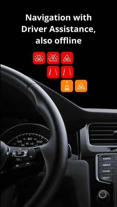
• Avoid collisions and accidents with Driver Assistance warnings: Headway Warning, Forward Collision Warning, Pedestrian Collision Warning, Lane Departure Warning, Leaving Lane Warning, Stop & Go Assist.
• Driver Assistance warnings and Recordings are available when the device is on a car mount in landscape mode, with a clear view of the road ahead.
Offizielle Bildschirmfotos
Produkt einzelheiten und Beschreibung von
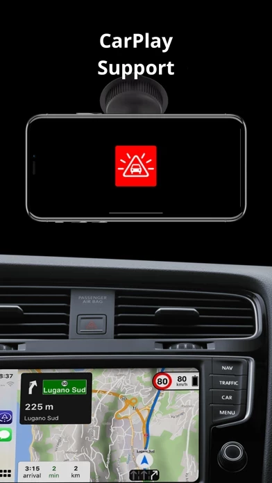
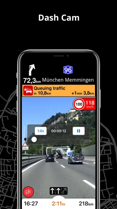
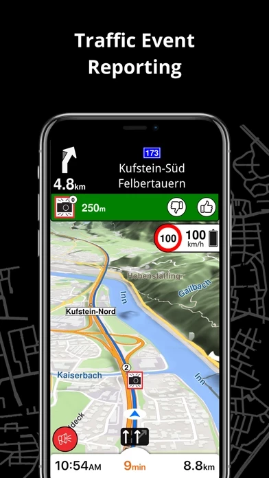
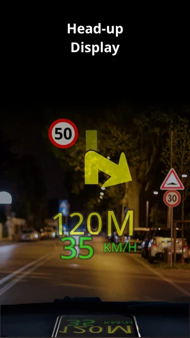
Find the best route to your destination even without an internet connection. Magic Earth uses OpenStreetMap data and a powerful search engine to offer you the optimal routes for driving, biking, hiking, and public transportation. PRIVACY FIRST! • We do not track you. We do not profile you. We do not trade in your personal data; moreover, we do not have it. MAPS • Save big on mobile internet costs and navigate reliably with offline maps powered by OpenStreetMap. 233 countries and regions are ready to be downloaded. • Choose between 2D, 3D, and Satellite map views. • Get ready for travel and know every detail of your route like surface, difficulty, distance and elevation profile. • Learn more about the points of interest near you from Wikipedia articles. • Spot nearby parking places to easily park your car. • Stay up-to-date and enjoy regular free map updates. AI DASHCAM • Improve safe driving and avoid accidents. Receive alerts to potential problems on the road and record your trip. • AI DashCam features Driver Assistance warnings and Dash Cam functionality. • Avoid collisions and accidents with Driver Assistance warnings: Headway Warning, Forward Collision Warning, Pedestrian Collision Warning, Lane Departure Warning, Leaving Lane Warning, Stop & Go Assist. • Record the road ahead during navigation to have an aid in the event of a collision or incident. • Driver Assistance warnings and Recordings are available when the device is on a car mount in landscape mode, with a clear view of the road ahead. CARPLAY compatibility • Connect to Apple CarPlay and enjoy the ultimate navigation experience. NAVIGATION • Find the fastest or the shortest route to your destination when you travel by car, bike, on foot or with public transport. • Plan your route with multiple waypoints. • Stay safe with the free Head-up Display (HUD) feature which projects the most important navigation info onto the windshield of your car. • Know in advance which lane to take with precise turn-by-turn navigation and lane assistance. • Get notified about speed cameras and stay up to date with current speed limits. TRAFFIC INFO • Get real-time traffic info, updated every minute. • Discover alternative routes that avoid traffic jams and save you time on the road. PUBLIC TRANSPORT • Get around town quickly and easily. Choose from public transit routes that combine all transportation modes: bus / metro / subway / light rail / train / ferry • Get walking directions, transfer times, departure times, number of stops. And when available, the cost. • Find wheelchair or bike-friendly public transportation. WEATHER • View current temperature and local weather forecasts for your favorite locations. • See what weather conditions to expect in the next hours and view the forecast for the next 14 days. NOTES: * Some features are not available in all countries. * Some features require internet connection.
Oben Erfahrungen und Bewertung
durch Jbl1234
Tolle Navi-App!
Ich benutze die App seit einigen Jahren und möchte mich mit dieser 5 Sterne Bewertung bei den Entwicklern dafür bedanken, dass sie uns ein so gutes Produkt kostenlos zur Verfügung stellen. Ich mag die Art der Navi-Darstellung. Klar fragt man sich manchmal auf bekannten Strecken, warum einen die App „links und nicht rechts rum“ schickt. Aber das habe ich auch bei anderen Apps erlebt. Letztendlich - und das zählt - kommt man immer ans Ziel. Und das meist sogar ziemlich genau zu der Zeit, die zu Beginn der Fahrt angezeigt wird. Ich mag die hinterlegten Karten, die sehr aktuell sind und fast jedes öffentliche POI (Gebäude, Geldautomat, Bushaltestelle, Bäcker etc) anzeigen. Unsere Tochter war als Fahr- und Navianfängerin damit im Ausland unterwegs und ohne Einweisung von mir damit direkt klargekommen. Mein Vorschlag: testet einfach mal die App. Gelöscht werden kann immer. Aber ich vermute, dass es dazu nicht kommen wird ... 😉
durch adg321
Super App mit einer Einschränkung
Ich bin wirklich sehr zufrieden mir dieser App. Was mich aber sehr stört ist die sehr ungenaue Geschwindigkeitsangabe. Es wird zum Beispiel bei Tempo 50 km/h nur 38 km/h angezeigt. Bei Geschwindigkeiten ab 80 Km/h wird die Abweichung dann geringer (ca.8 km/h). Das muss dringend gefixt werden (IPhone 6s). Ich habe andere Apps getestet, das wurde das Tempo immer korrekt angezeigt. Dann gibt es auch 5 Sterne. Vielen Dank für die schnelle Rückantwort von der Entwicklung. Das nenne ich eine top Support. Ich freue mich schon auf das Update im AppStore. Wegen dem herausragenden Support gibt es trotz der momentan beschriebenen Einschränkung 5 Sterne.
durch Remi2011
Nicht nur die schönste Karte...
Ich habe Google, Waze, Sygic und andere probiert. Google und Waze fressen meine Privatsphäre und mein Datenvolumen. Sind aber soweit sehr gut. Sygic fährt eine eigentümliche Preispolitik. Der erweiterte Spurassistent (das Killerfeature für mich) auf dem iPhone ist genial. Trotz Premium Lizenz und extra Premium Carplay samt Aufpreis gibt's den Spurassistent nicht mehr auf dem Carplay. Obwohl es in diversen Videos zu sehen ist. MAGIC EARTH bietet zwar nur einen vereinfachten Spurassistent aber ansonsten ALLES was es an Features gibt. OfflineKarten, Blitzerwarnung usw. und die optisch einfach schlnsten 3D Karten samt Landschaft und Gebäuden usw. Echt top!! Und alles gratis. Irre!