i-Hunting : GPS Maps App Software
Company Name: Bist LLC
About: BIST Group is an IT and audio visual solutions where every customer is an individual.
Headquarters: Bingley, Bradford, United Kingdom.
i Hunting GPS Maps App Overview
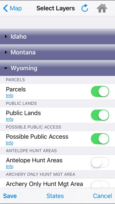
zones, restricted areas, possible access areas, state refgues and more.
√ Vector USGS contours (Change height to ft or meter).
Official Screenshots

Product Details and Description of
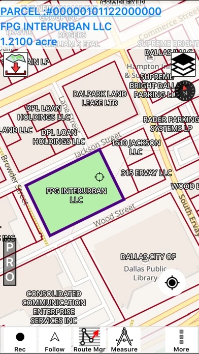
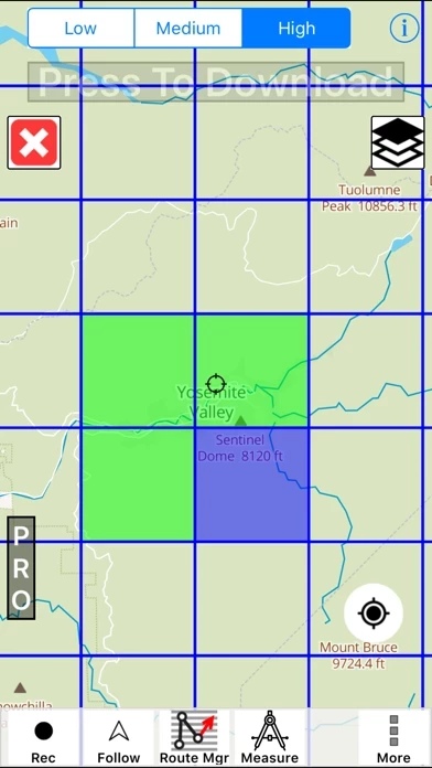
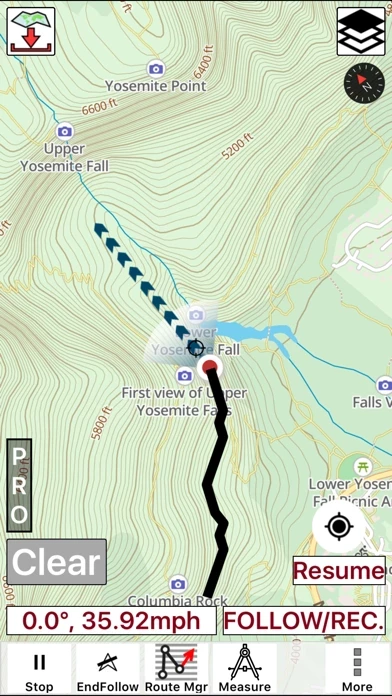
This hunting GPS app provides access to property line maps, parcels & public lands, land ownership details. Map layers for 50+ states include hunting zones, restricted areas, possible access areas, state refgues and more. Vector topo maps with most accurate USGS elevation contours, hiking & biking trails. Coverage includes all US states. ► Vector Topo Maps √ Beautiful & detailed Hardware/GPU accelerated vector maps (text stays upright on rotation) √ Vector USGS contours (Change height to ft or meter). √ Covers popular hiking & biking trails and paths ► Parcel Maps √ Includes following ownerhsip attributes (where available) * Owner name and Owner address * Site Address * Parcel ID Total Value ► Hunt Planning maps √ Possible Public Access √ Public lands and Parcels √ Hunting Zones √ Game Distribution √ Restricted Ares √ Portions ► Offline vector maps √ Easy to download offline topos ► PLSS maps √ PLSS Townships and Sections (US Wide coverage) ► Custom base maps √ Switch base maps between vector topos, hybrid satellite imagery and more ►GPS FEATURES √ Record Tracks √ Enter or import Waypoints. √ Auto Follow * Real Time Track Overlay * Predicted Path Vector * Course Up(Text stays upright) * Speed & Heading √ Route Assistance With Voice Prompts * Prompts when approaching a boating route marker * Continous distance & ETA updates * Alerts when off route * Alerts when moving in wrong direction ►ROUTE MANAGEMENT / TRIP PLANNING √ Create New Route/Edit Existing Routes √ Move Points √ Add points to an existing route leg √ Delete / Rename points √ Import GPX,KML & KMZ files √ Plot/Edit Routes √ Enter Waypoints √ Share/Export Routes,Tracks&Markers √ Reverse Routes ►Solunar Forecast * Sun Rise, Sun Set * Moon Rise, Moon Set, Moon Transit, Moon Phase * Major & Minor activity times * Day Scale ► SHARING * Share tracks/routes/markers on Facebook & Twitter * Export tracks/routes/markers as compressed GPX files.
Top Reviews
By CoachJAB85
Actually useful!
This is a great app if you are looking for land maps with property line and ownership info. I like it how the parcel boundaries are highlighted when I focus on it and the ownership info appears on top. The application includes tons of layers, WMA boundaries that are easy to customize as a map overlay. One of the setting that I found only in this app is the ability to change elevation unit from feet to meter.
By LSchick98
Lots of options and accurate
This app really shows a lot of the unmarked trails and fire roads I use fishing compared to standard maps. And the quick switching between layers really helps find new spots with knowing is it public or private access. Really looking forward to downloading some offline maps and testing the accuracy.
By BunnyHop14
I strongly recommend it
Property lines are clearly drawn and highlight when you put them under map cursor. If you hunt near private boundaries, you should definitely get this app