Gaia GPS: Mobile Trail Maps Reviews

Gaia GPS: Mobile Trail Maps Reviews

Published by on 2023-11-10

About: Explore the world with Gaia GPS, your premier guide for finding trails around
the world. Beloved by millions worldwide and featured in countless publications
like the New York Times, Washington Post, and GearJunkie, Gaia GPS provides the
best offline maps and navigation tools for your adventures.


About Gaia GPS


What is Gaia GPS?

Gaia GPS is a navigation app that provides offline maps and navigation tools for outdoor adventures. It offers a wide range of features for hiking, backpacking, trail running, camping, overlanding, backcountry skiing, mountain biking, and professional use. The app is available for free with limited maps, and a premium version is available for full online and offline access to the map catalog.


Features


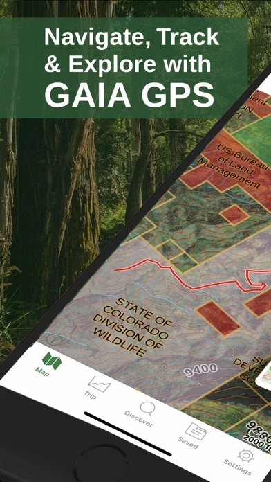
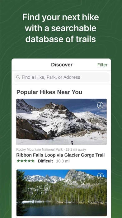
- Discover hiking trails and plan your own routes with Gaia Topo, the world’s most powerful backcountry map.

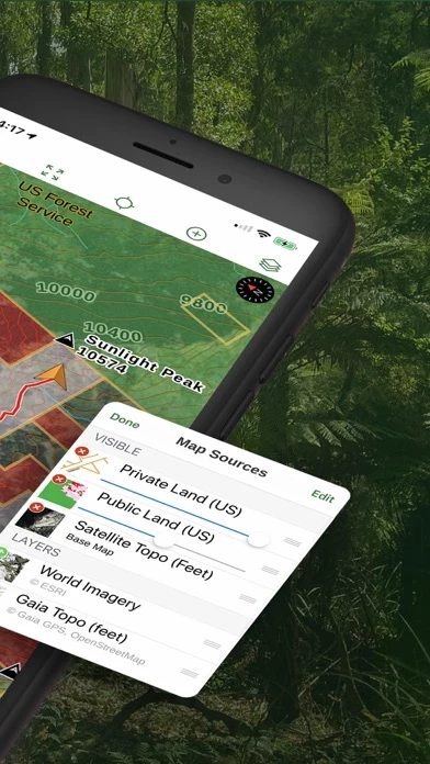
- Explore hundreds of professional maps, including Nat Geo Trails Illustrated, USFS, and hi-res satellite imagery.

- Take your maps offline so you always know where you are, even far from cell service.

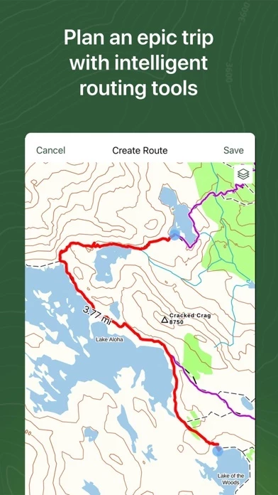
- Use our intelligent route planner to create routes on the fly.

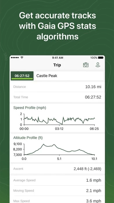
- Use our app as an altitude, elevation and distance tracker for each hike.

- Mark campsites and points of interest, drop photo waypoints.

- Get weather forecasts to stay on top of changing conditions.

- Discover camping and reserve sites right from the map.

- Find dispersed camping far from the crowds with public and private land boundaries and USFS maps.

- The premier offroad app for planning, navigating, and recording 4x4 and overlanding adventures.

- Identify avalanche terrain with slope angle shading and topographic information.

- Find the best trails curated by the team over at Trailforks.

- Gaia GPS is the preferred nav app for outdoor professionals.

- Free – limited maps, for online use only.

- Premium – full online and offline access to the map catalog; print custom maps.


Overall User Satisfaction Rating


Positive experience
79.7%

Negative experience
20.3%

Neutral
12.9%

~ from Justuseapp.com NLP analysis of 29,728 combined software reviews.

Key Benefits of Gaia GPS

- Gives peace of mind to tackle trips that would otherwise not be comfortable attempting

- Includes interactive trail lines and various map layers to design accurate, safe trips

- Upgrades have continued to improve the app

- Personal property lines and public layers

- Popular mapping app

- Solves problems and much more


20 Gaia GPS Reviews

4.8 out of 5

By


Importing back country camping zones

I use the Gaia iPhone app almost exclusively to plan my adventures, and I rely on it constantly while hiking to stay oriented and on plan. It gives me the peace of mind to tackle trips I would otherwise not feel comfortable attempting. For planning I use GaiaGPS literally hours each day: route creating, adjusting, recreating; adding waypoints for important, interesting things to note while hiking; relying on the included interactive trail lines and the various map layers to design accurate, safe trips. It is by far the most important tool in my hiking toolbox. Even though I’ve gotten quite good at using GaiaGPS , I’m continually finding new and amazing things it can do. For instance, I’m planning a backpacking trip to Denali where backcountry camping is regulated by zones and quotas. The National Park Service has a wonderful paper map that shows these zones. I found that their website allowed me to download a data file of the zones and to my delight I discovered the Gaia app easily imported them along with included metadata. What an amazing planning feature. I have many other examples of how I use GaiaGPS but will save them for future reviews. Don’t think twice: buy the pro version and use it, use it, use it.


By


Best GPS and map source available and has been for many years..

I got GaiaGPS about 10 years ago and I have loved it the upgrades have continued to improve it very well. I would not go with any other app out there I have tried other ones like x hunt and I did not like it. It is years behind GaiaGPS. You get the personal property lines and public with GaiaGPS, lots of layers that you can overlay and download. My entire family and extended family got GaiaGPS too and they love it as well. Don’t waste your time or money with one of the other apps. This one is the way to go. Best app available. And I use this all the time not just once a year while hunting. I use it for hunting, fishing, camping, hiking, snowmobiling, horse pack trips around the farm... the tracking ability is very accurate and doesn’t drain my battery. I turn off my cellular data and all that and use it to track and it goes all day with out killing my battery and I have a 3 year old I phone. This is the only app that I would recommend especially because I have tried about 20 other ones over the years and this is the one I stick with. The subscription is worth every penny as well. Don’t worry you get your money’s worth with GaiaGPS. They have an amazing app.


By


Nice but dated UI

Firstly GaiaGPS is useful and it’s convenient for what I need but seems so far behind alternatives like OnX when it comes to a clean and intuitive user interface. Almost like comparing DOS to modern day Windows. If I didn’t already pay for this one I’d switch, but since I have it, I’d like to help make it better. There needs to be better graphics in general and more customization options for waypoints when you click on them. It also really bugs me that you can’t just select waypoints already on the map… you have to click near it and it drops a giant new waypoint, and then it brings up nearby points and you can select your pre-saved waypoint below... good lord that’s unnecessarily complicated. PLEASE, get rid of the waypoint with one click.. it’s such a bad design. At least make it a selectable option in settings? I get the intent but it doesn’t need to be THAT easy to add a waypoint. Adding a waypoint SHOULD be a long press on the map, or just by using the (+) button - not just a simple click on the map, that way people can just tap on pre-existing waypoints/pins/trails and bring up their information without having to constantly clear out a newly placed pin every... single.. time I click on the map. This seems like such a simple fix and would make GaiaGPS about 1000x better and less annoying.

Thanks


By


Hands down the best digital map app ever created

I have been a power user of GPS devices and digital maps since the earliest handheld GPS units long before smartphones. I’ve used them extensively for exploring and hunting throughout the western US, Canada, Alaska, and a little in Africa and Europe. I’ve used most of the popular mapping apps. Until Gaia came along we had to rely on a certain app to obtain land ownership status which is important for hunting and hiking access in the western states. But the other app was weak in so many other ways. Gaia solves these problems and much more. The suite of map layers is unparalleled. Game management units, USFS, roads and trails, satellite, numerous topo maps, private and government lands, parcel ownership data, Nat Geo Trails Illustrated, and much more. It’s all there. And exceptionally easy to download and use. Super stable and simple to use. The tracking function works perfectly. Sharing of waypoints and tracks is simple and reliable. So many thoughtful and useful features. Gaia is simply a brilliant outdoor activity maps and GPS app. Regular updates make it better all the time too. Premium subscription is worth much more than it costs.


By


Great App with a couple minor issues

Let me start by saying I use a Premium Subscription and absolutely love GaiaGPS and use it nearly daily for both work and recreation. I does so much that it has become a must for use with my fieldwork. My only complaints are the randomized coloring when importing tracks and the was area shapes are created. Using GaiaGPS professionally, I often need all of my shapes to be specific colors or all one color. Often I can just quickly adjust them in GaiaGPS , but when I have projects with hundreds of shapes this is no longer a viable option and is very frustrating. Simply allowing bulk adjustment would solve this problem for me. The second issue regarding creating areas is that often when I try to move the dots that adjust the area, it grabs the screen and tries to move it instead... sensitivity issue maybe? In any case, these issues are not deal breakers... I love GaiaGPS and will continue to use it, but hope that these two simple things will be addressed in the future. I know I’m not the only one that would like to see this! Thanks for a great app!!!


By


Best GPS and hiking trail map app

I love GaiaGPS because it doesn’t drain my precious cell phone battery and works great on airplane mode. We just finished a 4- day climb of Mt Whitney and Gaia performed so well! It oven had a map of the fires on the other side of the sierra ridge that I had downloaded before we left Whitney portal. I was able to photograph many locations along the trail and correlate them easily to their locations on the map. I love this aspect. There are a few improvements like making the photo UConn a little smaller and making the relationship between the map, the compas heading, and the direction of travel more intuitive, but it was probably me doing weird things like angling my phone up in the air etc etc

Lovely app thanks!!! Had my topo map but never used it because Gaia was so good. This is the first time I’ve used it for an extended trip away from cell phone reception and I found it to perform better than expected. For over a year I’ve been mainly using it to record day hikes and keep track of my biking and running and hiking workouts.


By


Unresponsive Technical Support

I’m quite pleased with the iPhone version of GaiaGPS. However, I like to search for and set up hikes on the iPad version, and this version has bugs. I’ve submitted tech support requests to deal with one or more of these, and am met with absolute silence. Especially since I’ve paid for the Premium version, I certainly expect better. The biggest technical issue I have is that I can search for, and find hikes for which summary info is displayed in the (left) sidebar, including a Preview Map. When I touch the sidebar map, a pop up appears asking me whether to display on the Main Map, Expand the Preview or Cancel. The Preview will expand if that is chosen. However, when choosing Display on Main Map, the area of the trail/hike is displayed by NOT the route of the hike. This fault makes the iPad version of Gaia GPS almost useless for any detailed planning. I’ve repeatedly asked for help with this from Tech Support and get absolutely no response. Conclusion - Don’t bother with the iPad version of GaiaGPS!

… Since posting this review and two weeks after posting my tech support request, I finally had a response. It did not resolve my issue, but at least it was a response, however, late.


By


I’d call it 4.5

I really enjoy using GaiaGPS I like to be able to go alone and I have been able to go farther past my skill level just by being confident I could always get back. Looking at doing the enchantments this year solo and I am so excited to not have to depend so much on others. I’ve also been able to find “the end” of my prior hikes and connect the dots in a way that would have required way too many maps and Gaia can always let me see how to put it all together. I have hiked regions for years with a desire to mentally map in a way that this gives me freedom to get back on trail. I wish when the battery died there was a way to continue the trip from where the device powered down. I love the create route but wish it would default in hiking mode without WiFi but over all my complaints are minor details for how much I’ve enjoyed being able to ID mountains correctly in the view and connect the dots instead of rely on speculation. Very much an upgrade to my ability to go farther and feel smart abt it.


By


Legit App, I use for hunting and Hiking

I love the GAIA GPS app.I heard about it one time when I was hunting in Idaho. A guy told me about it and told me how you could download maps. There’s absolutely no service where we were hunting in Idaho but he had download it all the maps and was able to charge his phone using a solar charger. Pretty cool that’s where I first heard about it and I’ve been using it ever cents it was about 2015 when I first started using it. I will say it has its bugs here and there but it’s, really long way. I haveSaved Way points for my favorite hunting spots and it’s pretty awesome every year I go back and there are still ready to go. I even got my dad to start using itAnd we hunt in the same area. It was very easy to share all of my weight points with him and so he had all of our history. A lot of times I will take pictures of landmarks and it saves it as a waypoint. I pay for the premium features so I get the hunting maps and all the other good maps that come with it. I have used onyx and other apps and I prefer the GAIA app.


By


Love it!

I have been a wildland firefighter and a guide for a wilderness therapy program (I used maps a lot in previous jobs!) and now I backpack and adventure in my off time and absolutely love GaiaGPS! The options for waypoints, taking pictures, routes, topography and off line ability show me where I am on the map is amazing. I even upgraded this summer (when wildfires were seemingly everywhere) to add the layer of hot spot detection. *I did not use this to decide where to hike during the fires, simply just to see where the fires were- very dangerous to be anywhere close to the forest fires as they can shift directions at anytime!
Gaia is great because roads and routes change all the time and great to have an updated map (though not always perfect- but the closest I have seen).
I have thought about buying a separate hand held GPS, but having GaiaGPS negates that need. 100% recommend GaiaGPS- it is free for basic things and you can pay for an upgrade if you want.


By


Great tool for mapping motorcycle trips that use lots of off-road.

I’ve been using GAIA to map my rides for a couple of years now. I use it to note where I’ve been, and to mark places I’d like to go, rather than mapping out routes beforehand. I like the detail available in the layers of maps available, (just purchased membership so as to be able to download and utilize Canada backroads layer) the ability to run GaiaGPS while phone is in airplane mode, and the relatively low power use in that mode.
I’ve ridden across the country west to east and back again, and from south to north, and largely off-road. And have records of each day’s ride.
I use it to map mountain bike rides and bicycle commutes, and keep multiple parent-folders current with each ride. I also like being able to share a link to my rides with family and friends. I know there are features I don’t use, but feel confident that their use would be pretty intuitive given the ease of use I experience with the features I do use.


By


Great to plan routes for off-road riding

Downloaded GaiaGPS and tested it for off-road motorcycle. The automatic tracing of a route over existing marked trails is an awesome feature that makes planning the route considerably easier than with Google Earth or Garmin Basecamp. I downloaded satellite image and usgs topo maps of the area I was riding in so I didn't need to rely on having network or not during the ride. Battery usage was reasonable and it can certainly last for 12 hours or more with every app turned off and airplane mode. The website is fairly good too. Only small complain is that the web app folder system is a little convoluted - it's not obvious at first where things go at first. The mobile app occasionally crashes while managing files, yet nothing was lost. Compare to a Garmin gps unit the only limitation is the device's gps accuracy and recording rate but it's no issue for off-road riding/driving, likely not an issue for hiking neither.


By


Lol best gps I used - better than dedicated gps devices

Been using GaiaGPS for several years. I pay for the annual subscription and it’s worth every penny. I use GaiaGPS for trail running and backpacking mainly. I have and iPhone and when out in spotty cell service areas I turn my phone on airplane mode and GaiaGPS works great as long as you have the maps downloaded earlier. Having the gps app on the phone gives you the modern touch screen and convince that the other dedicated devices (garmin) are still struggling to replicate. The phone is something I already have and the battery in my iPhone last a long time. I also like being able to use GaiaGPS on my computer and plot/estimate plan hikes and runs. It will give you distance and elevation which are things I like to know before going out on long runs in areas I never been. I can’t say enough great things about GaiaGPS, it’s great!


By


Awesome! Needs some features though!

PROS: I have been using GaiaGPS to find trails to ride my dirt bike on. GaiaGPS does a great job in that it distinctly marks different types of trails and has shown me trails I would have never know otherwise and has taken me way off the beaten path!

CONS: One feature that I believe is completely necessary is a Map Filter. For example, if I want to view only Double Track Roads / Unmaintained Roads, I should be able to filter my map to only show those roads. It would make finding new roads a lot easier , since currently you have to visually sort through lots of different roads/trails.

Another problem is that a lot of landmarks and trails only show up at a certain zoom level .For example, I have been using GaiaGPS to show me less popular waterfalls. Once again a map filter for waterfalls would be fantastic. In addition, most of the smaller waterfalls only show up on the map if your map is set at a zoom of 2000ft or more. This means you will have to painstakingly search by panning through GaiaGPS at 2000ft which is way too zoomed in. If I could see all waterfalls that exist at a 2 miles scale or larger , that would be great !

These downfalls are what’s keeping me from paying for the subscription since it does not appear that the subscription gives you access to these features !

Hopefully this review can inspire an update! I’d love to hear from a developer !
Rick C.


By


Ok, but missing important and very basic tools

I’ve been using Gaia for a while now. Some for hiking, some for overlanding and dual sport, and some for Backcountry Enduro biking. For the most part GaiaGPS is ok. It’s simple to save maps and record tracks and easy to download GPX files from 3rd parties. But it’s missing some of the most critical and simple functions. At first I simply couldn’t believe what it was missing, but after watching Gaia tutorials and spending time on blogs, I’ve learned it truly doesn’t have them. For example, when route planning you can’t see the distance between waypoints! Unbelievable. On our motorbikes we have limited fuel, so I need to be able to plan for that. I literally have to use a physical grade-school ruler on my screen to estimate distance between waypoints to plan for fuel stops. It’s also very difficult to adjust a route later. Anyway, GaiaGPS could be great but falls miserably short for route planning. Currently planning an Idaho BDR trip and Gaia simply won’t work. Currently looking for a better solution.


By


Saved my life!

I currently run the free version off GaiaGPS but plan to pay for it after it saved mine and two others lives! Other than keeping us on our trail and knowledge of elevation and topo lines it contained our exact coordinates when things got hairy! An unexpected snow storm rolled in on us and lasted a little over 48 hours and full on blocked us in on a trail that was hiking access only. We managed to get cell service at the top of a cliff and send out our gps coordinates from GaiaGPS and as soon as the storm cleared we were evacuated safe and sound with minor symptoms of hypothermia. Had I not had GaiaGPS we would have been in a far worse situation just waiting for them to find us as pinging our phones lead them to believe we were two mountain passes over. I never thought a silly map app would be something I relied on so heavily!


By


The best

One of the best mobile apps hands down. GaiaGPS has easily saved me from getting lost several times. It might have even saved my life. The interface may not be the most intuitive but once I got used to it, I was fine. GaiaGPS has ALWAYS worked without cellular service. I’ve used it in this manner over a dozen times for a total of about 30 days in two countries. The key is to download an area map to your device before you leave cellular coverage and load it when you are ready. It’s also helpful to establish known waypoints before but no biggie if you don’t. Two negative observations some of Colorado’s 14ers are listed at the wrong altitude and if you cache equipment and use GaiaGPS to waypoint the arrow that shows your location to the waypoint will continuously move location even though you are standing still. It still, in my opinion, a 5 star app!


By


Excellent app except

Gaia gps is my go to tool when it comes to finding or creating biking,running, or hiking routes. I gave it 5 stars because of how convenient the many different map layers are.I am a huge trail and nature guy and I was tired of using standard maps that missed so much trails. Well Gaia gps took care of that problem, in fact Gaia gps has not missed one trail in my area and has helped me discover ones I never new existed. It’s also helped me successfully navigate my routes and unfamiliar territory easily and without getting lost. I am thankful for the very existence of GaiaGPS. With all that said there is one problem. When I use the create route function the map becomes laggy and difficult to use. this is the one thing keeping GaiaGPS from being totally flawless. So please on the next update patch this issue.


By


Sounds Like Updates are in the Works

I appreciate having received a developer response that some of the shortcomings outlined below are being addressed. I’d still go with Gaia over the others, and I’d still say there are some needed QOL additions.

Some things I believe need work:

Poor organization of trips - why have folders and then display every prospective route in the “folders” view? Why no bulk add of multiple routes and waypoints to one folder?

There’s no way to see your waypoints on an elevation, such that your waypoints for overnight camps appear in the elevation view. This matters because you can’t get accurate mileage from one camp to the next when planning routes. The only way I can find to do that is to make separate routes for each day, which is fine, until you go to look at the “folder view” and find it filled with 30 or 40 separate routes from various prospective trips.

There doesn’t appear to be an “out and back” option to create a full “out and back mileage” and elevation profile - the best you can do is create another point somewhere near the origin. But you can’t put the final point directly on the origin, because doing so grabs and moves the origin point. Multiplying is easy enough, but other apps have this feature, and it’s a nice add.

I have used other apps, and each has its own shortcomings. All this said, Gaia is easier to use than others, and it gets the job done.


By


Best off road navigation app available

I have been using Gaia for about 4 years. It is the best app available for making routes and marking spots on the trails. You can take photos while on a trail and the pictures will be placed on your maps exactly where you took the pictures. It’s not too difficult to learn. You can easily import or export your tracks/routes to share externally or you can even share your routes within GaiaGPS . I would and do recommend Gaia. I started with the free version and then the first level upgrade and am now using the premium 5 year subscription version. You can find discount codes on several overland forums. The free free is perfect because it let me try it out before I committed to the full purchase. Try it and I am positive you will love it as much as I do!


By


Garmin killer?

I initially got GaiaGPS (basic membership) as a backup to my garmin unit while riding the backcountry on my dual my sport dirt bike. I have both gps and phone mounted on the handlebars of my motorcycle and have the Gaia app running to explore trails and track my rides. So far I’m really happy with the way GaiaGPS works and how accurate the gps is using the offline maps. After using the Gaia gps for a couple weeks it might become my primary gps and the garmin will go in my pack as the backup.

Another feature that I like is the ability to create waypoints and routes from the Gaia website and have the routes auto sync to the phone app. This it much easier and faster than the garmin/basecamp setup and makes pre-route planning a breeze. You can also import gpx files from waypoints into the web portal pretty easily.


By


This app is the best mapping program on the iPhone iPad and even the computer.

GaiaGPS is an awesome mapping program for the iPhone iPad and even the computer. The Apple Watch provides stats and can mark a waypoint, but so far it has not loaded a map on my watch.
We even used Gaia GPS to hike in southern France, Including the Pyrenees mountains along the France Spain border and in Canada’s national Parc Pucaskaw on the north shore of Lake Superior We use GaiaGPS for all of our volunteer work for the Forest Service, BLM, Fish and Wildlife Service, NPS, and Idaho Fish and Game. We subscribe directly through the Gaia GPS website.
With a battery juice pack to extend the battery on my phone, there’s plenty of juice for a 200 point count, plus navigating back to the truck and back to pavement, and inputting the data, so I can email it when we have cell service.


By


Gaia GPS is Fun!

I’ve loved maps ever since I can remember. This tool makes somethings so easy, that I’m sure some will abuse it. Such is the result of powerful technology, in the hands of not nice, or incompetent people.

The ability to overlay several maps (paid version only), allows the background color schemes for public lands, to show through both a topo map, and a satellite view. That is powerful!

Need permission to access a swimming hole, or inspirational view? Want to know whose property adjoins the hunting area you want to access? The BLM signs of evaluation to change the status of public roads from open, to limited (or closed), can come into focus when the surrounding landowners are known.

Gaia GPS makes documenting locations of statues downtown possible (even where buildings obscure and confuse GPS signals), by allowing a waypoint to be moved, and the pictures to be labeled. Different color schemes can be used for defining different segments of a walk/tour.

One aspect that needs improvement is the estimated position accuracy. Kudos for including an estimate of the accuracy of the reported location, but the uncertainty algorithm needs work.

Great product! Fun to use. The professional features are well worth paying for, as the map overlays proved.


By


The best map application I’ve found

This is my first “detailed” online review ever, for any product. The closest I’ve come is giving something a few stars, but never in detail. I’ve always been the end user of reviews, but GaiaGPS is well worth the time to share.

I’m a bit of a map fanboy. I’ve always loved them and currently have 7 map apps installed on my phone. I often wonder why, when I always end up using Gaia GPS. The interface takes a little bit of time to get used to, but the power of the tool is well worth it. I’m continuously finding new features of GaiaGPS and I love all the different options. I haven’t found any other application that can do something Gaia can’t.

I can’t recommend it enough, you will not be disappointed!


By


Unreliable

I’ve been using GaiaGPS for 2 years and have never had an issue. In the past month, GaiaGPS has failed me twice. The first time I was on a 20 mile train run in Olympic National Park and my map was showing up completely blank aside from the location arrow. Never happened before. I had downloaded the map area prior to this so I could see it offline, GaiaGPS just wasn’t working. This was poor timing as I lost the trail due to snow conditions. Fortunately, I crossed paths with some backpackers and found my way. This happened again yesterday in the Central Cascades and I had to turn back one mile into my journey. Today, a notification popped up when I opened GaiaGPS saying that GaiaGPS was not responsible for any failures and “services are provided at your sole risk”. I really have no idea what the point of having GPS is if you can’t rely on it. Obviously, it is smart to have a back up plan for any kind of technology failure. However, I simply can’t use GaiaGPS anymore, I have no idea if it will work or not.


By


Confusing payment levels

Gaia is a great map app. I’m paying for a basic membership and see a minor improvement over the free version. But it is an improvement so I’m not complaining. It’s easy to understand there are 3 levels of membership but I found it difficult to understand exactly what features are unlocked with each membership. For example, overlays, the feature I most desired, is no available in the basic membership. If it’s affordable for you, I would advise you to purchase the “premium membership” to remove any limitations. I wish I could clearly display the features for each membership in this review. If the premium membership’s cost is a barrier for you. You should chat with Gaia support before you buy to know which membership is right for you before you spend money.


By


Rough start but great outcome

I started using GaiaGPS like so many others on the free version and loved everything about it. I finally decided to get the premium version and of course a day maybe two before I had a trip planned as leader of a group of jeeps travel across the eastern section of Oklahoma there was an update and it caused some hectic and I couldn’t use the MVUM maps which wouldn’t have been good. Anyways I got in touch with the tech support guys and through Facebook messenger and was able to get the help I needed before I left out for my trip. Absolutely some of the best service I’ve had in a while. I will continue to use GaiaGPS for as long as they keep up the good work. Thanks guys


By


Bkkls

I left my old review below but have talked to someone at gaia They listened and I felt confident my issues will be addressed.I sent 3 emails and waiting to see if I get a response. they are the best app out there for your phone they will get 5 stars after I receive answers to my emails
Old review below
Even though i can use it for 2 years free unless their going to go back and take that away to . I am disappointed in the new app and in management of the buiness . There are so many maps that are worthless have no purpose . I have called them with suggestions of maps to add and to point out a mistake on one map and all i got was someone very defensive no help at all . I will not pay a monthly or yearly fee i will drop GaiaGPS and use my dependable garmin rhino


By


No cell service, no problem

GaiaGPS has become my go to GPS, even replacing my trusty Garmin. I can’t say enough about it. You can pre-download your maps, so no cell service is even needed, it just works off of satellites. You can alter the downloaded map’s file size too by determining how much you want to zoom in. You can back up/sync your trips as well. My buddies who have GPS’s are amazed by GaiaGPS and have jumped on board. I use it for snowmobiling, fishing, backcountry alpine hikes, ATV trips, etc. I carry a portable USB battery charger too though I keep my phone in airplane mode the whole time in the backcountry to preserve battery (and yes, satellites and tracking still works, just make sure you enable it).


Is Gaia GPS Safe?


Yes. Gaia GPS: Mobile Trail Maps is very safe to use. This is based on our NLP (Natural language processing) analysis of over 29,728 User Reviews sourced from the Appstore and the appstore cumulative rating of 4.8/5 . Justuseapp Safety Score for Gaia GPS Is 79.7/100.


Is Gaia GPS Legit?


Yes. Gaia GPS: Mobile Trail Maps is a totally legit app. This conclusion was arrived at by running over 29,728 Gaia GPS: Mobile Trail Maps User Reviews through our NLP machine learning process to determine if users believe the app is legitimate or not. Based on this, Justuseapp Legitimacy Score for Gaia GPS Is 92.6/100..


Is Gaia GPS: Mobile Trail Maps not working?


Gaia GPS: Mobile Trail Maps works most of the time. If it is not working for you, we recommend you excersise some patience and retry later or Contact Support.


Pricing Information

**Pricing data is based on average subscription prices reported by Justuseapp.com users..

- Free: limited maps, for online use only.

- Premium: $9.99/month or $39.99/year, full online and offline access to the map catalog; print custom maps.


How was your experience with Gaia GPS: Mobile Trail Maps? Post a Review

Leave a comment:


Alternatives