National Hurricane Center Data Logiciel
Nom de la société: LW Brands, LLC
À propos: Full-service marketing solutions
Siège social: Bonita Springs, Florida, United States.
National Hurricane Center Data Présentation
In total, there are now over 100+ hurricane / weather tracking products to help you stay informed during hurricane season.
More than sixty (60+) new hurricane tracking products were added for the 2020 Hurricane Season.
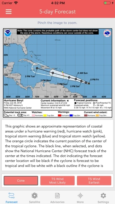
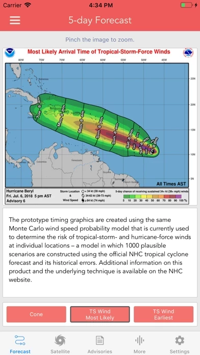
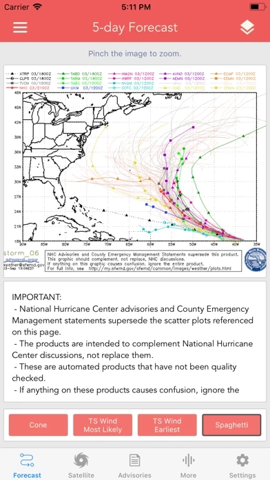
Models included in spaghetti graphics include: HWRF, HMON, CTCX, AVNO, SHF5 & OFCL.
* Track, Intensity and Pressure graphics include spaghetti plots when available.
Note: Local threat graphics are typically not available until shortly before storm landfall.
Captures d'écran officielles
Détails du produit et description de
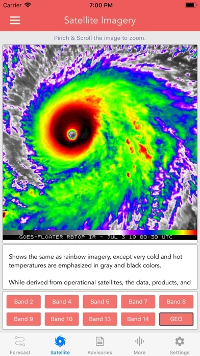
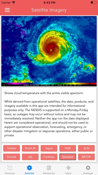
Download the most comprehensive Hurricane Tracker app for iOS. MAIN FEATURES INCLUDE: + GOES Satellite Imagery Animations + National Hurricane Center Products + National Weather Service Alerts + Weather Prediction Center Graphics + Tropical Weather Push Notifications + Satellite Imagery Home Screen Widget + Spaghetti Models GRAPHICAL PRODUCTS INCLUDE: Forecast Graphics - Spaghetti Models - 5-Day Tropical Weather Outlook - 3-Day Excessive Rainfall Outlook - 7-Day Quantitative Precipitation Forecast Storm Specific Graphics - Key Messages - Cone Track Forecast - Tropical Storm Wind (Most Likely) - Tropical Storm Wind (Earliest) - Hurricane Wind Probability - Surface Wind Field - Surface Wind Analysis - Wind / Track History - Rainfall Forecast - Flash Flood Risk Local Storm Threat Graphics - Flooding Rain Threat - Wind Threat - Surge Threat - Tornado Threat - Rainfall Totals - Wind Warnings Note: Local threat graphics are typically not available until shortly before storm landfall. TEXT PRODUCTS INCLUDE: - Tropical Weather Outlook - Forecast Advisories - Public Advisories - Forecast Office Discussion - Local Statement (HLS) - Local Warnings (TCV) - Tropical Discussion - Wind Analysis WEATHER MAP OVERLAYS INCLUDE: - Hurricane Track & Intensity - Potential Storm Surge Flooding - NASA Sea Surface Temperature - NOAA Weather Radar GOES SATELLITE IMAGERY INCLUDES: Fifteen (15) Satellite Imagery Filters - Visible (Band 2) - Near IR (Bands 4 & 5) - Infrared (Bands 7, 8, 9, 10, 13, 14 & 16) - Nighttime Microphysics - Day Cloud Phase - True Color - Air Mass - Sandwich APPLE WATCH APP INCLUDES: - View wind speed & intensity updates every 30 minutes - View the latest satellite imagery - Choose from a variety of Watch Complications -- PRO SUBSCRIPTION FEATURES -- Full Screen, High Resolution Satellite Imagery: - Latest Image - Animated Loop - Mesoscale: Near Real-time Imagery - Geostationary Lightning Mapper (GLM) Mesoscale imagery typically has 1-minute temporal resolution, but is not always available for each storm. 16-day Weather Forecast Models: - Global Forecast System (GFS) - Global Ensemble Forecast System (GEFS) - North American Ensemble (NAEFS) Weather Simulation Forecast Models: - Hi-Res Rapid Refresh (HRRR) - Hi-Res Ensemble Forecast (HREF) - North American Mesoscale (NAM) - Hi-Res North American Mesoscale (NAM-HIRES) - High Resolution Window (HRW-FV3, HRW-ARW, HRW-ARW2) - WaveWatch III (WW3) - European Centre for Medium-Range Weather (ECMWF) HMON & HWRF Hurricane Forecast Models Experimental Forecast Animations: - Simulated Radar 2km - Surface Pressure, Wind - 200mb Temp, Ht, Wind - 700mb RH, Ht, Wind - 850mb Vort, Wind, Thick Model Analysis & Guidance Animations: - 6h Total Precipitation - 10m Wind - 200mb Vort, Wind, Ht - 500mb Relative Humidity - 700mb Vort, Wind, Ht - 850mb Vort, Wind, Ht Static Forecast Products - Track* - Intensity* - Pressure* - Rain - Wind * Track, Intensity and Pressure graphics include spaghetti plots when available. Models included in spaghetti graphics include: HWRF, HMON, CTCX, AVNO, SHF5 & OFCL. NCEP / EMC Cyclogenesis Tracking Products - 16-day Storm Forecast Tracks - 21-day Global Tropics Hazards Outlook - 35-day Probability of Formation CIMSS Tropical Cyclone Products - Wind Vorticity & Shear Analysis - Steering Layer Analysis - Morphed Integrated Microwave Imagery - Advanced Dvorak Technique (ADTV9.0) ADT Includes imagery, wind radii estimates & trends Interactive Hurricane Tracker Map - Track & Intensity Forecast - Preliminary Best Track Analysis TERMS & CONDITIONS https://lwbrandsllc.com/hurricane-app-terms-conditions/ -- In total, there are now over 100+ hurricane / weather tracking products to help you stay informed during hurricane season.
Haut Avis
Par Somers971
Useful
We use it always and it’s perfect and clear. Thank you
Par Doctela
Nécessaire
Très bonne application en tout temps et saison
Par jojococo31
Langue
Annoncé avec langue Française ... une fois installée l application ne propose pas de changement de langue