Hiking Project Software
Company Name: Recreational Equipment, Inc
About: Miracle Recreation Equipment Company is a recreational facility company providing outdoor playground
equipment.
Headquarters: , , .
Hiking Project Overview
What is Hiking Project?
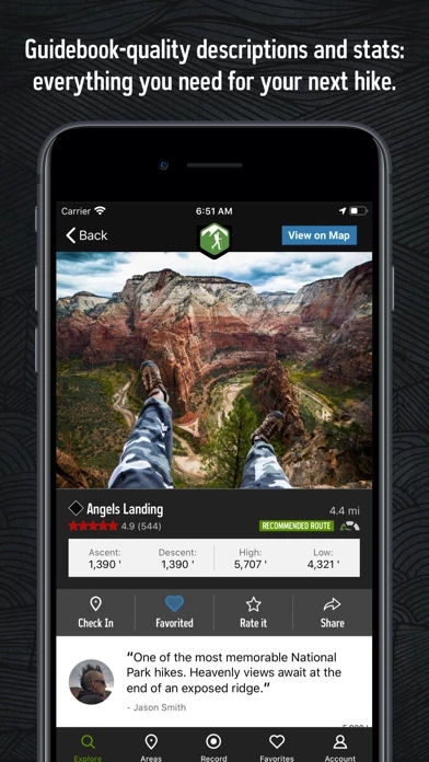
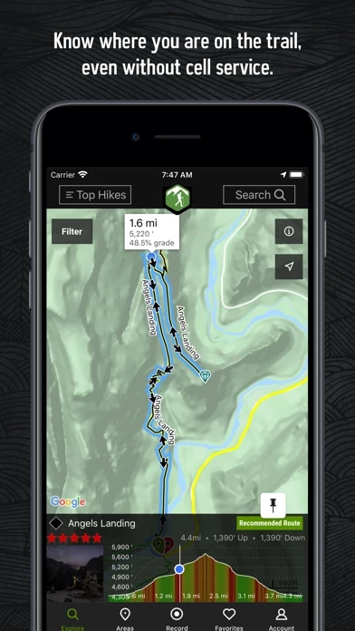
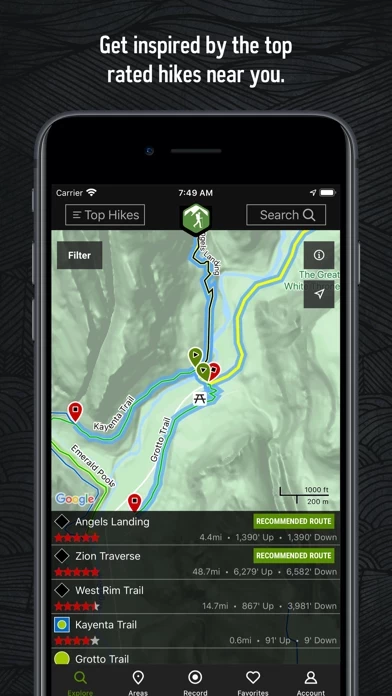
Hiking Project is an app that serves as a comprehensive guide to the best hikes near you. It offers full GPS route information, elevation profiles, interactive features, photos, and more. The app suggests the best featured hikes to explore, either near your current location or in an area you search for. Local experts provide insights and highlights to help you plan a great day on the trails.
Features
- Provides access to over 74,000 miles of trail to hike with your crew.
- Constantly adds new trails to its detailed hiking database.
- Shows your exact location on the trail using GPS.
- Allows downloaded trails to work offline, even when there is no cell reception.
- Offers high-resolution photos and detailed topographical trail maps.
- Syncs with your to-do list and check-ins on HikingProject.com.
- Uses GPS to show your location on trails and vertical profiles. Note that continued use of GPS running in the background can dramatically decrease battery life.
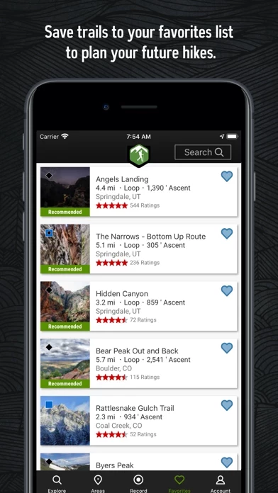
Official Screenshots

Product Details and Description of
Hiking Project is your comprehensive guide to the best hikes near you, wherever you are. With the thoroughness of a printed map, we offer full GPS route info, elevation profiles, interactive features, photos, and more. Like a guidebook, we suggest the best featured hikes to explore—either near your current location or in an area you search for. Local experts show you the highlights, challenging features, and insights you need to plan a great day on the trails. • Find over 74,000 miles of trail to hike with your crew. • New trails are constantly added to our incredibly detailed hiking database. • Your exact location is shown on the trail. • Downloaded trails work offline for when you’re off the grid. (No cell reception required!) • Enjoy high-resolution photos and detailed topographical trail maps. • We’ll sync with your to-do list and check ins on this app.com. By using GPS, we can show your location on trails and vertical profiles. Continued use of GPS running in the background can dramatically decrease battery life.
Top Reviews
By tubamindfreak
An Incredible Tool
Whether you are a novice to hiking or you’re an expert, this app is a must have. The Hiking Project is an awesome resource for planning your next hiking adventure; it also makes a great resource while on the trail. It’s trail library curated with excellent standards for photographs and GPS accuracy when submitting new trails to the system. The elevation graphs of the trails are extremely informative and so is the fact that the graphs are interactive. And most of all, this app allows you to accurately determine your own location on the trail in situations where you are conserving your phone’s battery by disconnecting from your cellular network or if you simply lose service. I still use good, old-fashioned maps of course but a multimodal approach to adventuring has always worked best for me. This app has helped increase my confidence and overall experience out on the trail. Whether backcountry camping or embarking on a day hike, I never play outside without it.
By Opinionzzzzz
Handy tool for the Appalachian Trail
I used the app to pick a trail segment to hike on the Appalachian Trail. I was able to download the map in advance (very handy since there was minimal data service during the hike). During the hike, it was really handy to see our progress via GPS, see Scenic Looking Spots and view nearby segments. I would like to see information added to the app about when we have to cross a street to continue on the trail and step by step instructions to get to the next segment. It would also be handy if the firepits were marked. We reached the end of the segment, didn’t realize we had to cross a street to get to the shelter further ahead. Then, we spent 30 minutes of hiking searching for a campsite with a fire ring. We were so tired we almost gave up. I’m very pleased with the app overall and will use it to find more local trails and hike other AT segments in the future.
By Gbass82
The app that every hiker needs
This is is great app that I have used countless times. Being able to access trail maps off line is fantastic because as we all know, the chances of having a phone signal on trail is slim. Knowing the terrain and elevations is a plus with the app and on my last hike, I tracked my location and kept up with what elevation changes I was about to encounter. My only complaint is that I wish the app could save my hike information (miles, elevation gains, etc.). Until this happens, I have to keep track of my data on another app. However, I am sure that as time goes on the app will eventually be able to do so and more. This app is a valuable tool for every hiker.