Cairn Overview
What is Cairn? Cairn is an app that helps users stay safe during outdoor adventures such as hiking, running, and camping. It allows users to share their plans with loved ones, find spots with cell coverage, download offline topo maps, see stats on their route, and record their hiking trail. The app also provides notifications to safety contacts when the user is past due, live tracking of the user's GPS location, and rescue advice for contacts to make intelligent rescue initiation decisions.
Features
- Notifications to safety contacts when the user is past due
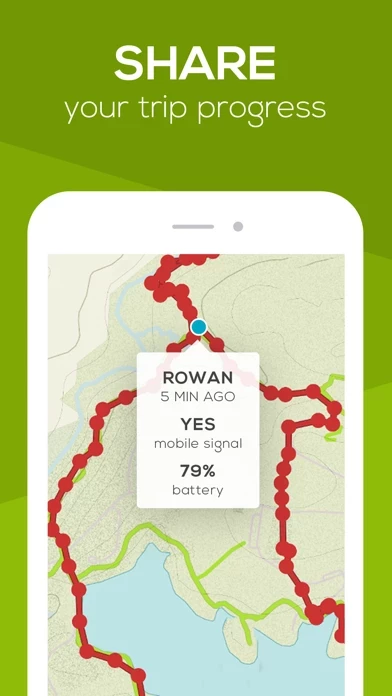
- Live tracking of the user's GPS location during their trip or hike
- Rescue advice for contacts to make intelligent rescue initiation decisions
- Know where others have found cell coverage
- Download maps designed specifically for outdoor pursuits
- Send status updates with a single tap
- Get live distance, elevation gain, and ETA stats for 4000+ hiking routes, summits, and trails worldwide
- Customize ETA stat based on activity type and speed
- Record and save the user's trail while they hike
- Easy to set up a Cairn
- Share plans with anyone without requiring an app
- Control how often Cairn collects GPS location and battery usage
- Great for hiking, backpacking, trail running, horseback riding, skiing, cycling, rock climbing, camping, hunting, fishing, boating, and more
- Free trial for 30 days without any commitment
- Subscription to access all features that help keep users safer in the outdoors
- Automatic renewal of subscriptions unless auto-renew is turned off at least 24-hours before the end of the current period
- Payment charged to iTunes Account at confirmation of Purchase
- Full terms of use available at https://www.cairnme.com/terms
- Support available via email at [email protected].
Official Screenshots


Product Details and Description of
this app helps you stay safe on your hikes, runs and outdoor adventures. Easily share your plans with loved ones, find spots with cell coverage, download offline topo maps, see stats on your route, and record your hiking trail. Named one of the three best map apps for navigating the wilderness by Outside Magazine. GET FOUND IF YOU’RE OVERDUE • Notifications: Safety contacts are notified when you’re past due • Live tracking: Contacts can see your GPS location during your trip or hike • Rescue advice: Contacts get important info needed to make intelligent rescue initiation decisions STAY CONNECTED IN THE OUTDOORS • Know where others have found cell coverage • Download maps that are designed specifically for outdoor pursuits • Send status updates with a single tap SEE TRAIL STATS • Get live distance, elevation gain and ETA stats for 4000+ hiking routes, summits, and trails worldwide • Customize your ETA stat based on your activity type (hiking, running, skiing, horseback riding, snow travel, mountain biking) and speed • Record and save your trail while you hike this app IS + Easy: It only takes a minute to set up a this app + Open: Share plans with anyone – no app required to view + Customizable: Control how often this app collects your GPS location and battery usage + Flexible: Great for hiking, backpacking, trail running, horseback riding, skiing, cycling, rock climbing, camping, hunting, fishing, boating and more FREE TRIAL While the maps, trails and cell coverage information are always free to access, you will also start a free trial when you install the app. This allows you to try every one of this app's features for a full 30 days without any commitment. The free trial expires automatically. SUBSCRIPTION We are committed to bringing you the best app for adventuring in the wilderness. By subscribing to this app you are helping to support and shape our continued efforts in this direction. Subscribers also get access to all the features that help keep you safer in the outdoors. • The free trial expires automatically; there is no need to cancel. • Subscriptions (not the free trial) automatically renews unless auto-renew is turned off at least 24-hours before the end of the current period. Your iTunes account will be charged for renewal within 24-hours prior to the end of the current period, and will identify the renewal cost. • Payment will be charged to iTunes Account at confirmation of Purchase. • Visit the following URL for full terms of use: https://www.cairnme.com/terms • Turn off auto-renewal via the main Settings app: https://support.apple.com/en-us/HT202039 Need support? Email us at [email protected].
Top Reviews
By SeattleSoccer
Awesome map/GPS app for hikers
This is a great app for hikers and backpackers. It’s easy to use. You can download maps so you can use them even when you are off-line. It uses the GPS chip in your phone so you can determine your location on the map. It helps you find places with cell phone signal if you need it. And it gives you an easy way to notify a circle of friends of where you are going and when you expect to be back. It notifies them if you are overdue, and you can check in to let them know that you returned safely. I use this on all my solo hikes.
By frohkid
This app is freaking fantastic
We have been using this app in Puerto Rico to help map all the science studies we have been doing in the rainforests above caguas after the hurricane. We have no cell service at all and little to no power. The ability to download detailed topography for free anywhere you might be traveling or working is amazing. I have also had a contact with the cairns team. I was having trouble signing in with my new phone. They were amazingly helpful, and prompt in their response. This app should should not be free. It is too good to be true. Keep it up y’all!
By Donna spokane Hiker
Peace of mind on hikes n runs
I came across this app from the local news and decided to give it a try. It's very easy to let family know where I'm going, allow them to track me, and sends out alerts with instructions when overdue. I now use it on all hike and trail runs in the wilderness. The ETA and GPS are very accurate and even used The cell coverage points to find a signal to send text messages off the grid. When I tell my family that I'm planning a hike they usually respond with don't forget to send a this app.