FltPlan Go for iPhone Software
Company Name: FltPlan.com (Flight Plan LLC)
FltPlan Go Overview
What is FltPlan Go? FltPlan Go is a flight planning app that is integrated with FltPlan.com. It allows users to create and file flight plans, access airport and weather information, and use powerful routing and mapping features. The app also includes additional features such as weight and balance computations, eLogbook entries, and checklists. FltPlan Go is compatible with various avionics, ADS-B, GPS, and simulator systems.
Features
- Integration with FltPlan.com for automatic syncing of flight plans, NavLogs, weight and balance profiles, eLogbook profiles, and checklists
- Ability to create and file flight plans on FltPlan.com or FltPlan Go
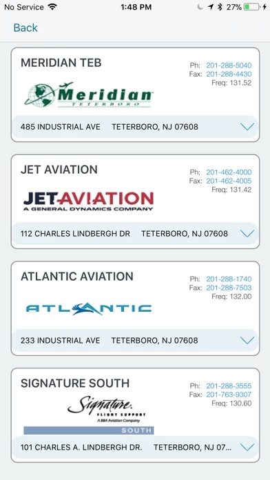
- Access to airport and FBO information, including current fuel prices
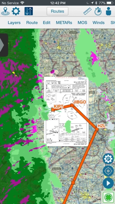
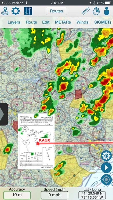
- Geo-referenced approach plates and airport diagrams for the US and Canada
- Weather information, including METARs, TAFs, PIREPs, MOS, and animated weather on the map
- NOTAMs and remarks
- Moving maps with sectionals, enroute charts, and more
- Overlay of approach plates and procedures on the map
- Layers including SUAs, TFRs, state outline, airports, fuel prices, CAP grid, stadiums, and customs
- Course deviation indicator (CDI)
- Creation or import of custom waypoints in KML or CSV format
- NavLogs that automatically sync and download for offline use, with the ability to email or print them
- Weight and balance computations with the option to email them
- eLogbook entries that sync to the eLogbook program
- Checklists that are synced from FltPlan.com for specific aircraft
- Creation of flight-specific binders with documents or procedures, airports, NavLogs, weather briefs, and more
- Aviation calculators
- Access to FltPlan.com
- Compatibility with various avionics, ADS-B, GPS, and simulator systems.
Official Screenshots


Product Details and Description of
FltPlan Go is the essential companion to FltPlan.com. Because FltPlan Go is integrated with FltPlan.com, flight plans and NavLogs are automatically synced to your device along with Weight & Balance profiles, eLogbook profiles, and Checklists for offline and in-flight use. • Create and file your flight plan on FltPlan.com, and it will sync to FltPlan Go to allow you to responsively edit the flight plan on the map • NavLogs are automatically synced and downloaded for offline use • Create and file your flight plan on FltPlan Go to sync to FltPlan.com FltPlan Go delivers powerful routing, weather, mapping features, and comprehensive aviation information including: AIRPORTS: • Airport & FBO Information including current fuel prices • Geo-Referenced approach plates & airport diagrams (U.S & Canada) • Weather, including METARs, TAFs, PIREPs, & MOS • NOTAMs & Remarks MAPS: • Sync FltPlan.com flight plans and interactively edit on the map • File a flight plan from within FltPlan Go • Moving maps with sectionals, enroute charts, & more • Overlay approach plates & procedures on the map • Layers including SUAs, TFRs, State Outline, Airports, Fuel Prices, CAP Grid, Stadiums, and Customs • Display METARs, Winds, SIGMETs, and animated Weather on the map • Display MOS weather forecasts (up to 4 days out) on the map • Breadcrumbs with enhanced playback & option to open in Google Earth • Display Search & Rescue patterns • Course Deviation Indicator (CDI) • Create or import Custom Waypoints in KML or CSV format • Overlay in-flight ADS-B traffic & weather or XM Weather* NAVLOGS: • NavLogs automatically sync and download for offline use • Email or print NavLogs from within FltPlan Go ADDITIONAL FEATURES: • Weight & Balance - create computations with the option to email • eLogbook - create logbook entries to sync to our eLogbook program • Checklists - synced from FltPlan.com for your specific aircraft • Binders - create flight specific binders with documents or procedures, airports, NavLogs, weather briefs, & more • Weather - search airport or route weather • Tracking - view live tracking • PDCs • Cloud Tops • Aviation Calculators • Access to FltPlan.com EXTERNAL: AVIONICS • Garmin • Dynon SkyView • Advanced Flight Systems • Avidyne IFD Series • DAC International GDC64 ADS-B • Garmin • Stratus 3 • Dual XGPS 170/190 • Dynon D2 • FreeFlight • Pathfinder • iLevil SW • L-3 Lynx • SkyGuard • Stratux • FlightBox • pingBuddy • Clarity • Custom Unit GPS • Garmin GDL 51 & GLO • Dual XGPS 150 • Bad Elf APP-TO-APP • Garmin Pilot • Satcom Direct • Jeppesen Mobile FD 2.7 SIMULATORS • X-Plane Simulator • FSX & Prepar3D *Subscription/Unit Required *Continued use of GPS running in the background can dramatically decrease battery life. FltPlan has grown into the largest flight planning company in North America. FltPlan covers the U.S., Canada, Mexico, Central America, the Caribbean, Panama, and parts of Venezuela and Columbia. FltPlan’s 165,000-plus active, registered users file more than 55% of all N#-registered flight plans. FltPlan Go is a part of FltPlan's comprehensive system that includes free, web-based flight planning and filing and a full range of premium services. FltPlan has more than 18 years of general aviation experience, giving pilots access to the best support team in the business. 24/7 FltPlan Go support is available at [email protected]
Top Reviews
By Level-D Sim
First App I Tried Since Two Decades Ago.
Came back to flying since from the mid ‘90s. Back then I needed two Jeppesen binders to cover the NE region and updating was a pain in the.....With this baby, I keep VFR, IFR and A/FD for my current area in the size of an iphone 7; and update with a click of a button. Just this ability is already amazing, now add the GPS, moving maps, superposition of weather, SIGMETs, METARs and approach plates onto the map, just WOW! I don’t need to compare it to paid services.
By Ty1364
This is a great app!
To be very honest free is not always the best way to go. As I have been using all three flight plan apps this is a great way to get it all and save. It’s not some cheesy app selling you all kinds of stuff on the side. It really is doing what it was to designed to do and that is guide you safely to your destination. Now that Garmin Pilot has acquired this it can only get more interpreted for the long and best. Thank you fltplan go.
By Vinceroo B
Fltplan Go is BETTER than Foreflight !
I use this app on my iPhone 7. I fly single-cockpit 180 knots VFR at 1,000 AGL below a Class B with 2 underlying Class C and 6 underlying Class D airports. All in mountainous terrain. The moving map TAC chart shows me exactly where I am with superb ground detail. By glancing at my iPhone I can keep my head out of the cockpit. Just what I need. Foreflight et al have way to much “high and IFR” stuff for quick safe low-level VFR navigation. KISS !