inRoute - Intelligent Routing Software
Company Name: Carob Apps, LLC
About: Carob Apps is a company that develops mobile softwares for masses. They have developed various apps
and softwares for iPhone
Headquarters: , , .
inRoute Overview
What is inRoute?
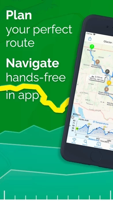
The InRoute app is a navigation app that allows users to plan optimal routes or chart their own course using weather, elevation, curves, and more. The app provides voice-guided, turn-by-turn directions that automatically check the route for severe weather. The app has been featured as a Best New App on the US App Store for Navigation and has been seen on the TODAY show in the Traveling This Summer segment.
Features
- Voice-guided navigation of up to 150 locations with automatic severe weather alerts
- Optimize waypoint order for fastest time or manually reorder
- Import from XLSX, GPX, and KML files
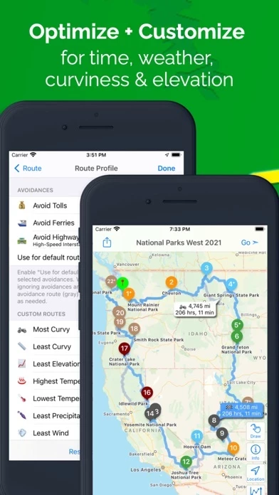
- Create custom routes based on weather, elevation, and curviness, or build your own route from available alternates on each leg of a route
- Interactive charts showing route elevation, curviness, weather (temperature, humidity, precipitation, wind speed/direction, severe weather alerts), and sunrise/sunset times
- Search along a route for gas, hotels, campgrounds, or places to eat close to a route
- Set Departure and Layover Times to accurately reflect conditions throughout the trip
- Save favorite routes and places, sync between devices, organize into folders, print via Airprint, and share with family and friends
- Easily add places to the map using a Dropped pin, Search, or Contacts
- Export routes to Apple Maps, Google Maps, Navigon, and Waze
- Export to GPS devices and apps compatible with GPX files
- Routes are stored on the device so users can access them even if they lose connection
- Weather forecasts are available worldwide. Severe weather alerts are currently available in the US, EU, Canada, and Israel.
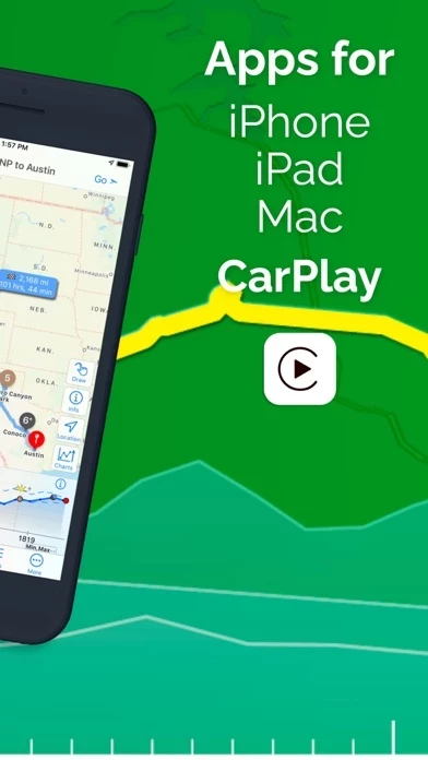
InRoute Pro (for iPhone, iPad, CarPlay & Mac):
- $4.99 monthly or $39.99 annually. 1 week free trial
- Create routes with up to 150 locations (8 in the free version)
- Sync routes and pins between devices
- Weather charts/custom routes
- Severe weather alerts during navigation (US, Canada, EU areas)
- Export/share routes as GPX files
Note: Continued use of GPS running in the background can dramatically decrease battery life, so InRoute will automatically shut down if not used in a while.
Official Screenshots


inRoute Pricing Plans
| Duration | Amount (USD) |
|---|---|
| Yearly Subscription | $39.99 |
**Pricing data is based on average subscription prices reported by Justuseapp.com users..
Product Details and Description of
Plan optimal routes or chart your own course using weather, elevation, curves and more. Then navigate safely with voice-guided, turn-by-turn directions that automatically check your route for severe weather. ***Featured as a Best New App on the US App Store for Navigation*** ***As seen on the TODAY show in the Traveling This Summer segment*** “adding to both the safety of the ride and the pleasure of knowing beforehand what to expect” - Florin Tibu, “autoevolution” “I used this app for planning six world record attempts. No weather app gives you more information, period.” - Carl Reese, Multiple World Record Holder Key Features (some require this app Pro--see below): • Voice guided navigation of up to 150 locations with automatic severe weather alerts* • Optimize waypoint order for fastest time, or manually reorder • Import from XLSX, GPX and KML files • Create custom routes based on weather, elevation and curviness, or build your own route from available alternates on each leg of a route • Interactive charts showing route elevation, curviness, weather (temperature, humidity, precipitation, wind speed/direction, severe weather alerts), and sunrise/sunset times* • Search along a route—the whole route, every x miles/hours, or the next x miles/hours from a place—find gas, hotels, campgrounds or places to eat close to a route • Set Departure and Layover Times—weather forecasts, road conditions (e.g. congestion), and travel times accurately reflect conditions throughout the trip • Save your favorite routes and places, sync between devices, organize into folders, print via Airprint, and share with family and friends • Easily add places to the map using a Dropped pin, Search, or Contacts • Export routes to Apple Maps, Google Maps, Navigon, and Waze. Some apps use this app's "Agenda Nav" feature. See the in-app FAQ for more info. • Export to GPS devices and apps compatible with GPX files • Routes are stored on your device so you can access them even if you lose connection *Weather forecasts are available worldwide. Severe weather alerts are currently available in the US, EU, Canada and Israel. this app Pro (for iPhone, iPad, CarPlay & Mac): - $4.99 monthly, or $39.99 annually. 1 week free trial - Create routes with up to 150 locations (8 in free version) - Sync routes and pins between devices - Weather charts/custom routes - Severe weather alerts during navigation (US, Canada, EU areas) - Export/share routes as GPX files Price may vary by location. Subscriptions will be charged to your credit card through your iTunes account. Your subscription will automatically renew unless canceled at least 24 hours before the end of the current period. Manage your subscriptions in Account Settings after purchase. Privacy Policy and Terms of Use: http://carobapps.com/privacy-policy Note: Since continued use of GPS running in the background can dramatically decrease battery life, this app will automatically shut down if you haven't used it in a while.
Top Reviews
By challngr
Planning Motorcycle Rides
Have been looking for a Route Planner, this works pretty well. Took some time to become familiar with the features, I use it for Motorcycle rides and its been fun planning out the Routes. After mapping out the trips, they can be titled and saved and can be shared. The app allows you to map out a desired route using what they call waypoints, the only problems I have found is, if you're not careful where you drop the way points, it will direct you off route, once you pass that way point, the app tries to redirect you back to that point . Would be cool if there were a skip button that directed you to the next waypoint on your programmed Route allowing you to continue the trip with out confusion, other than that, as I said before, it works Pretty well. 2/18 update Apparently they listen well, there is a skip button if you want to proceed past a waypoint..cool! Now I wish there were a version for a desk top, if I could map out a route on my IMac and transfer the route to my phone or a flash drive, that would be awesome, Great updates so far, loving the app!!
By Royal Ryder
The best routing app out there!
Like many other motorcyclists, I have looked for and tried many map routing programs and apps. But none compare to the succwss I have had using this app. The fact that I can design my own back roads route is worth a lot, since I stay off Interstates whenever possible. Most other apps force you to map out the shorest and/or fastest route, which is usually not my objectvei at all. Add to that the funcaitonality that this app connects with my iPhone and iPad at the same time, allowing me to develop the route on iPad with the larger screen and then use that route via bliue tooth from my iPhone to my headset while ion the road makes this app totally usable and functional for the serious rider. Topping it all off is the quick responsiviness of the Help desk when you have a question. They helped me understand the various commands and functions in a short period of time and ocntinue to support me long after the app was purchased. I've actually talked with the developer himself! I would give this app 10 stars if allowed!
By qmsiees
Great app
I purchased the enhanced version with 100 waypoint capability. I use the app on an IPAD (with larger screen) to locate good twisty roads for motorcycle rides. When I finish a route, the app shows the distance and time required to ride it. I can adjust the route to get a good ride time (for me-about 4 hours). I export the route to Dropbox as a .gpx file and import it onto the this app app on my IPHONE. I mount the IPHONE on my handlebars, connect my SENA Bluetooth and ride. The voice instructions work great. The IPHONE display is good enough to see the upcoming turns. For my Harley, I load the .gpx file on a thumb drive and upload it to the NAV system. Works well on the Harley if you remember to go into IPAD settings and set not to export unused pins. If you let the unused pins export, your Harley NAV system will take you home first then start the ride. When you start a new route 100 miles from home, that feature does not work out well. I share .gpx files back and forth with several friends who ride. We have built up quite a library for Tennessee.