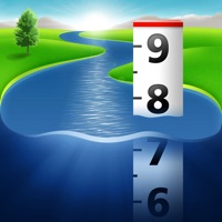
RiverApp Overview
What is RiverApp?
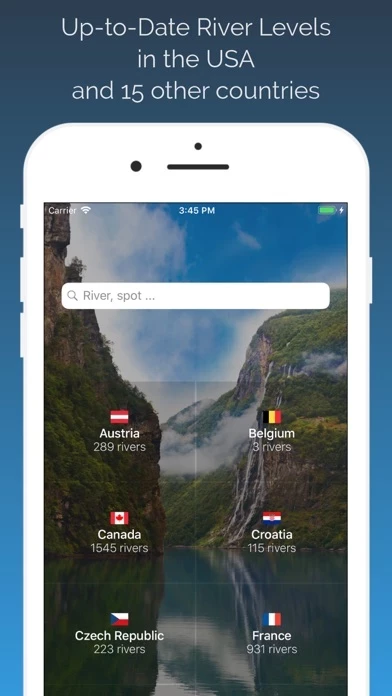
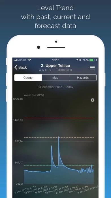
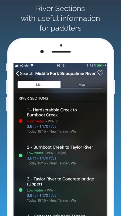
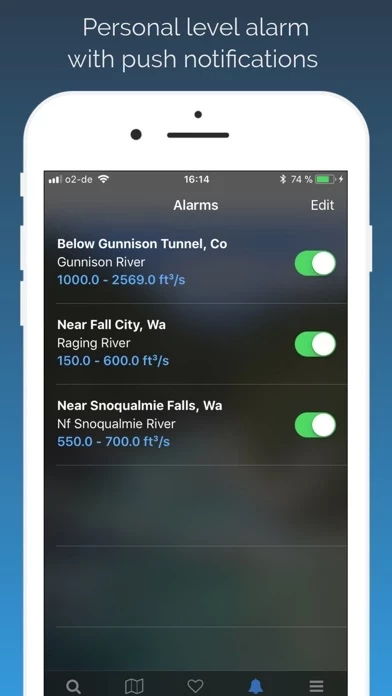
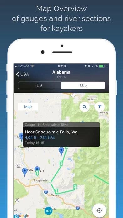
RiverApp is a mobile application designed for kayakers, water sports enthusiasts, fishermen, and anyone who is interested in river-related activities. The app provides users with water levels, flow forecasts, and navigability conditions of over 15,000 rivers in the USA and around the world. It also offers a map view of runnable kayaking routes and gauges, custom river level alerts, and information on 2000 river sections for paddlers, freestyle spots, and whitewater parks.
Features
- Water levels of 15,000 rivers in the USA and around the world
- Map view of runnable kayaking routes and gauges
- Water level and flow forecasts of the hydrological institutes
- Custom river level alert by push notifications
- 2000 river sections for paddlers, freestyle spots, and whitewater parks with display of put in and take out locations
- Display of the navigability of kayaking routes (low water, medium water, and high water)
- Advanced favorite features: favorite rivers, favorite stations, or favorite courses with
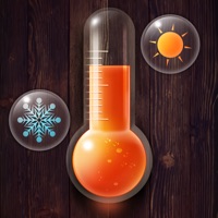
- Water temperature in many rivers and lakes
- Display/insertion of the navigability conditions of rivers (trees, dangers, etc.)
- Historical data up to several years ago (with RiverApp Premium)
- Water level and flow forecasts for many stations (with RiverApp Premium)
Sources of information include NVE, California Data Exchange Center, Government of Canada (Wateroffice), USGS, NOAA, PEGELONLINE, HVZ Baden Württemberg, HDN Bayern, Kanton Bern, Ennskraftwerke, Land Kärnten, Land Niederösterreich, Regione Piemonte, HVZ RLP, Český hydrometeorologický ústav, HVZ Sachsen-Anhalt, Land Salzburg, Scottish Environment Protection Agency, Slovak hydrometeorological institute, Agencija Republike Slovenije za okolje, HWZ Steiermark, BAFU, HNZ Thüringen, Land Tirol, Shoothill, Vigicrue, and Serveur de données hydrométriques temps réel du bassin Rhône Méditerranée.
Note: RiverApp Premium requires a single purchase or one-year subscription. Subscription automatically renews unless auto-renew is turned off at least 24-hours before the end of the current period. Account will be charged for renewal within 24-hours prior to the end of the current period. You can manage your subscription and turn off auto-renewal in your iTunes Account Settings after purchase. Payment will be charged to iTunes Account at confirmation of purchase. Terms and conditions apply.
Official Screenshots
Product Details and Description of
this app is a must have to check river conditions! this app is the ideal application for kayakers, water sports enthusiasts, fishermen and anyone with river-related activities. Features: For free: -> Water levels of 15,000 rivers in the USA and around the world -> Map view of runnable kayaking routes and gauges -> Water level and flow forecasts of the hydrological institutes -> Custom river level alert by Push notifications -> 2000 river sections for paddlers, Freestyle spots and Whitewater Parks with display of put in and take out locations. -> Display of the navigability of kayaking routes (low water, medium water and high water) -> Advanced Favorite Features: favorite rivers, favorite stations or favorite courses with -> Water temperature in many rivers and lakes -> Display / insertion of the navigability conditions of rivers (trees, dangers... etc) with this app Premium (Single Purchase or one year subscription): -> Historical data up to several years ago -> Water level and flow forecasts for many stations Sources: - NVE - California Data Exchange Center - Government of Canada (Wateroffice) - USGS - NOAA - PEGELONLINE (www.pegelonline.wsv.de) - HVZ Baden Württemberg - HDN Bayern - Kanton Bern - Ennskraftwerke - Land Kärnten - Land Niederösterreich - NVE - Regione Piemonte - HVZ RLP - Český hydrometeorologický ústav - HVZ Sachsen-Anhalt - Land Salzburg - Scottish Environment Protection Agency - Slovak hydrometeorological institute - Agencija Republike Slovenije za okolje - HWZ Steiermark - BAFU - HNZ Thüringen - Land Tirol - Shoothill - Vigicrue - Serveur de données hydrométriques temps réel du bassin Rhône Méditerranée - Land Vorarlberg Notes about this app Premium one year subscription: Subscription automatically renews unless auto-renew is turned off at least 24-hours before the end of the current period. Account will be charged for renewal within 24-hours prior to the end of the current period. You can manage your subscription and turn off auto-renewal in your iTunes Account Settings after purchase. Payment will be charged to iTunes Account at confirmation of purchase. Terms and conditions: https://www.this app.net/terms_and_conditions this app and the listed organizations are not liable for any errors or omissions in the Information and shall not be liable for any loss, injury or damage of any kind caused by its use.
Top Reviews
By Rogue26
Great App!!!
I have been looking for a user friendly application and stumbled upon this one. Not only is it user friend but the design is beautiful. I monitor river levels at work and this application has all of them. A bonus is that you can enable push notifications based on min/max flows at specific gage stations. I have contacted the developer about adding additional stations and received immediate response even on a weekend his is a five star application for sure. Thanks for the great effort and an application that solves a number of problems for me.
By AMA274
The Information is ok, but .....
Editing this review.... the developer worked with me and updated the app and now it works perfectly.... changing review from 1 star to 5! I purchased this app after I upgraded my phone and my previous river level app was no longer available. I PURCHASED the app which won’t acknowledge that I did purchase it and won’t allow me to use more than the free app features. When I click restore purchase, nothing happens.
By jace carter unruh
Recommended app!
I love this app. Although it updates slower than I would like it to, it doesn’t bother me to much. The graphics are outstanding and the charts are easy to read and understand! I would highly recommend this app to any whitewater kayaker who is looking for an app such as this one.(@jjmp1298, the premium won’t give you future water levels unless it is dam released. Natural water flow is impossible to predict)