Rivercast - Levels & Forecasts Software
Company Name: Juggernaut Technology, Inc.
About: The Unfair Advantage™ on Amazon. Global Leader in Amazon Advertising MSP/SaaS for Agencies, Brands
& Sellers. 7+ Billion Managed on Amazon
Headquarters: Excelsior, Minnesota, United States.
Rivercast Overview
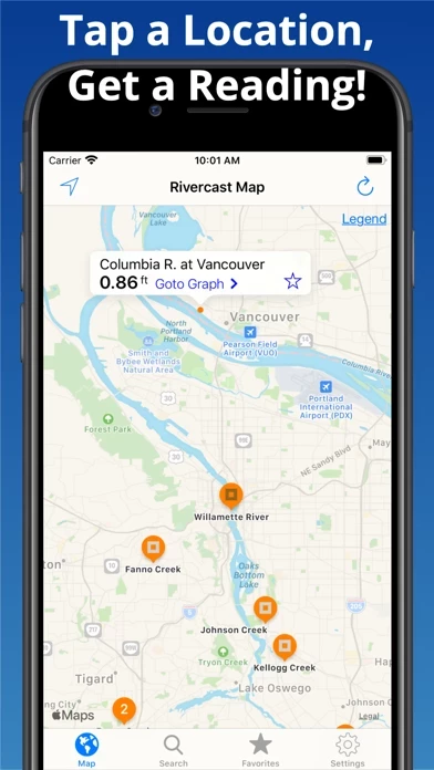
What is Rivercast? Rivercast™ is an app that provides river level data through interactive maps and graphs. It offers official flood warnings, river stage height, river flow rate, indications of approaching flood stage, current observations, and NOAA river forecasts. The app has a map interface that shows where river gauges are located geographically, a search interface to find river gauges, and interactive graphs that can be customized by adding relevant river levels. Users can also create a favorites list, share graphs via social media, and monitor their favorite locations through a widget.
Features
- Official Flood Warnings & other alerts from the National Weather Service
- River stage height in Feet
- River flow rate in CFS (when available)
- Indications that a river is at or approaching flood stage
- Current observations and recent history
- NOAA river forecasts (when available)
- Map interface that shows where river gauges are located geographically
- Search interface to find river gauges by waterway name, state, or NOAA 5 digit station ID
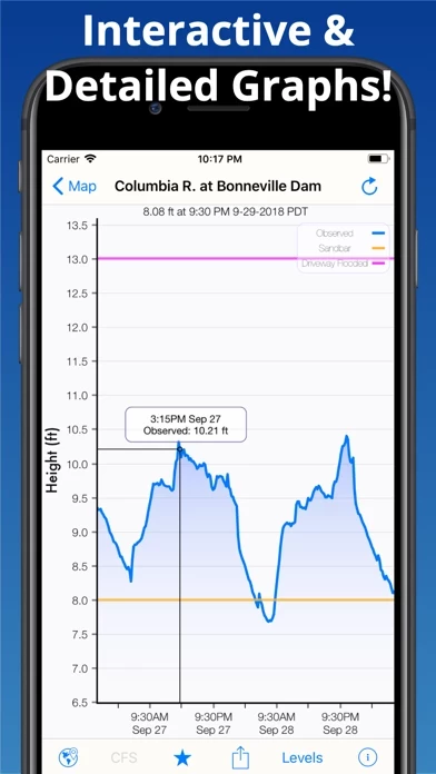
- Interactive graphs that can be zoomed in, zoomed out, or panned
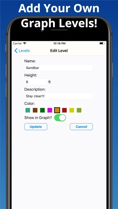
- Customizable graphs by adding river levels that are relevant to the user
- Favorites list for locations that the user cares about the most
- Shareable graphs via iMessage, Email, Facebook, or Twitter
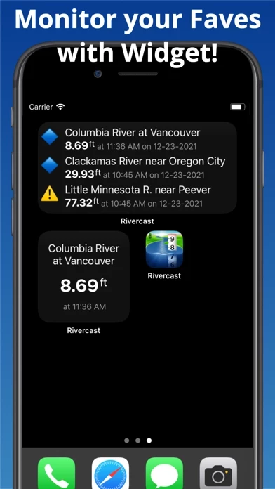
- Widget to monitor favorite locations at any time
- Color-coded map that indicates whether the location is at normal levels, approaching flood levels, or above flood stage
- Latest observations from the map, search, or favorites
- Detailed interactive hydrograph that can be accessed with an additional tap
- Ability to add own level lines to customize graphs
- Uses the latest observation and forecast data available
- Requires an Internet connection for use
- Favorites, Map "Instant Observations", and Hydrograph data is viewable in feet or cfs (when available)
- All observation and forecast data is in the user's local time
- USA-only river gauges reported
- Uses NOAA and AHPS for its raw data for custom graphing and mapping solutions
- Variances in CFS data may sometimes occur due to using different data models
- NOAA issues forecasts for many, but not all, rivers it monitors
- River gauges occasionally have technical problems transmitting their data or can get washed out during extreme flooding
- Includes all stations that NOAA provides for public use.
Official Screenshots

Product Details and Description of
this app™ puts the river level data you need at your fingertips with its intuitive and interactive maps and graphs. With this app™ you get: • Official Flood Warnings & other alerts from the National Weather Service • River stage height in Feet • River flow rate in CFS (when available) • Indications that a river is at or approaching flood stage • Current observations and recent history • NOAA river forecasts (when available) • Map interface that shows where river gauges are located geographically. • Search interface to find river gauges by waterway name, state, or NOAA 5 digit station ID. • Interactive graphs that you can zoom in, zoom out, or pan. • Customize your graphs by adding river levels that are relevant to you. • Favorites list for locations you care about the most. • Share your graphs via iMessage, Email, Facebook, or Twitter. • Widget to monitor your favorite locations at any time. this app's map not only shows you where the stations are, but color codes them when it can to give you an indication whether the location is at normal levels, approaching flood levels, or above flood stage. You can get the latest observations from the map, search, or favorites. With an additional tap of your finger you can get a detailed interactive hydrograph. You can zoom in, zoom out, or pan with your fingers to find the exact information you need. If you "tap and hold" on the graph you can view the crosshair "bubble" text to assist you further. To customize your graphs for what's important to you, you can add your own level lines to mark things like sandbars, rocks, bridges, safe conditions, or whatever you would like. And you can add the streams or rivers that you would like to regularly monitor to your Favorites list for easy "at a glance" viewing. this app™ uses the latest observation and forecast data available, and requires an Internet connection for use. We recommend 3G or better for optimal performance. Favorites, Map "Instant Observations", and Hydrograph data is viewable in feet or cfs (when available). All observation and forecast data is in your local time (per your device) for your convenience. A handy tool for boaters, fishermen, property owners, paddlers, scientists, and the curious. River gauges reported are USA only. * * * * * * * * * * * * * Some Frequent Asked Questions: Where does this app™ get its data? • This app uses NOAA and AHPS (Advanced Hydrologic Prediction Service) for its raw data for our custom graphing and mapping solutions. There are some locations that are available via other government agencies (including USGS) that are not available via this app. Why does this app™ sometimes show slightly different flow data (CFS) than USGS? • CFS is a calculated estimate derived from stage height. NOAA and USGS estimates may sometimes slightly vary due to using different data models. Variances are usually within a few percent, but can sometimes be larger. Stage height should always be identical between USGS and NOAA. Designated flood stages are based on stage height in feet in the USA. Why does this app™ show only observations, but not forecasts, for my river? • NOAA issues forecasts for many, but not all, rivers it monitors. Sometimes forecasts are only issued seasonally, or during times of flooding or high water. My river gauge was there yesterday, but its gone today! What gives? • River gauges have a hard life. They occasionally have technical problems transmitting their data, or can even get washed out during extreme flooding. NOAA is usually pretty good about fixing them in a few days. Can you add location xyz to your app? • We wish we could! If NOAA is not reporting it, we unfortunately are not able to add it. We include all stations that NOAA provides for public use. We take our accuracy seriously! If you have any questions, please email us! Terms of Use: https://www.apple.com/legal/internet-services/itunes/dev/stdeula/
Top Reviews
By Montana's Last Best Outfitters
Everyday Use and Reliability
I've been a guide in Montana for 15+ years and as an owner of an outfitting business here, this app is huge for not only my businesses day to day operations but for my days off as well. Because we offer trips on so many waters across the state and YNP, we have guides fishing different waters and stretches daily. I used other similar apps before but the map layout and favorites on this one make it so much quicker and easier to use. You'll never find one with all of the gauge stations and data, but these guys are close and they keep working on it. Great app and as a fourth generation Montanan and guide, I highly recommend it.
By JR4AL
Great App For Fisherman To Watch River Levels
This app is the real deal! I had an issue that was quickly resolved and I stand corrected and I do apologize for suggesting any ill thoughts about this app or its developers in a previous post. Cory (a developer) reached out to me and the issue was a glitch either on my end or theirs but nonetheless the issue was resolved efficiently and professionally. This is a great app and I would encourage anyone to subscribe for the premium content especially fishermen that need to know what the river is doing so they can plan their trip accordingly. Get this app. Great information and class acts running it!
By bite and hook
Larry
Love this app, just wish it would show more history… I use this app for planning my salmon and steelhead fishing trips. No one can predict very accurately where river levels will be more than a few days to perhaps a week ahead. But seeing more history would be very handy as well… So I can go back and see where the river level was when we had a great day.