Avenza Maps: Offline Mapping Software
Company Name: Avenza Systems Inc.
About: Avenza Systems is a computer software company located in Toronto.
Headquarters: Toronto, Ontario, Canada.
Avenza Maps Overview
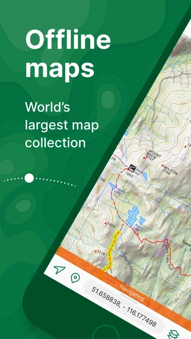
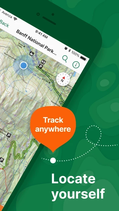
What is Avenza Maps? Avenza Maps is a free app for hiking, biking, and all trails that features maps from National Geographic, national parks, and more. The app allows users to stay on track with GPS using offline mobile maps and import custom maps. It also offers the largest mobile Map Store of hiking, topographic, cycling, city, nautical, travel, and trail maps. Avenza Maps is available for free, with maps available for free or purchase from the in-app Map Store. Plus and Pro subscriptions are available for unlimited custom map imports and professional users with full access to all features and mapping tools.
Features
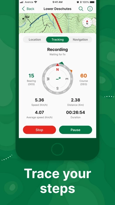
- Realtime GPS position and direction finding, even when offline
- GPS track recording during activities
- Compass tools for navigating to features
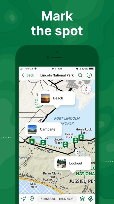
- Adding photos and notes to any location
- Placemarks with recreational symbols
- Distance measurement and time estimation
- Supports KML, GPX, and CSV Formats
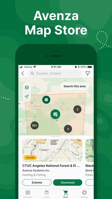
- Map Store with premium maps from various publishers
- Avenza Maps Plus subscription for unlimited import of custom maps and geofencing
- Avenza Maps Pro subscription for high-accuracy GPS devices, unlimited geofences, Esri Shapefile import, and more
- Annual subscriptions available through Apple ID with auto-renewal options
- Support available through support.avenzamaps.com
- Privacy Policy and Terms of Use available on avenzamaps.com
- Social media connections with Avenza Maps on Facebook, Twitter, and Instagram.
Official Screenshots
Product Details and Description of
Avenza Maps, #1 app for hiking, biking and all trails. Featuring maps from National Geographic, national parks and more! On your next adventure, stay on track with GPS using offline mobile maps. Make your own maps? Import your custom maps and never get lost off the grid. Explore the largest mobile Map Store of hiking, topographic, cycling, city, nautical, travel, and trail maps. Featuring maps from professional publishers including National Geographic, National Park Service, and the US Forest Service. Discover maps for your next camping, fishing, or backpacking trip with your family and friends. Navigate confidently when off-roading or taking those backcountry trails. Precisely identify your location with what3words and stay safe wherever you are. Avenza Maps is free and the best map app for recreational use. Maps are available for free or purchase from the in-app Map Store. Plus subscription is available for unlimited custom map imports. Pro subscription is available for professional users with full access to all features and mapping tools. Avenza Maps for your offline adventures on all trails! ENHANCE YOUR MAPS WITH THESE FEATURES - Locate your realtime GPS position and find direction, even when offline - Record GPS tracks during your activities - Navigate to features using compass tools - Add photos and notes to any location - Add placemarks to your map and style them with recreational symbols - Measure distances and estimate times - Supports KML, GPX, and CSV Formats EXPLORE THE MAP STORE Search and download maps by activity, category, and specific publishers with premium maps from: - National Geographic - Michelin - Backroad Mapbooks (BRMB) - New York - New Jersey Trail Conference - USFS (United States Forest Service) - USGS (United States Geological Survey) - FAA (Federal Aviation Administration) - NOAA (National Oceanic and Atmospheric Administration) - BLM (Bureau of Land Management) - HarperCollins - DeLorme Atlas & Gazetteer / Garmin - BaseImage - National Park Service - And thousands more! A free account lets you access all of your map downloads. GET MORE WITH AVENZA MAPS PLUS For recreational and power users who need more - Unlimited import of your own geospatial PDF, GeoPDF®, and GeoTIFF maps - Create geofences for up to 50 individual features and up to four geofence layers GET EVEN MORE WITH AVENZA MAPS PRO For professionals and organizations who require an offline mapping solution with location awareness with more features and tools - Unlimited import of your own geospatial PDF, GeoPDF®, and GeoTIFF maps - GPS averaging, additional coordinate display formats, custom symbol sets - Connect high-accuracy GPS devices including Trimble, Bad Elf, and Dual via Bluetooth - Created unlimited geofences and get global geofence notifications - Convert tracks to areas - Map orientation lock - Import and export Esri® Shapefiles - Import and manage custom symbology sets - Priority technical support Avenza Maps Pro subscription required for commercial, academic, government, and professional use. Avenza Maps Plus and Pro are available as annual subscriptions. You can subscribe and pay through your Apple ID. Subscriptions are 12 months in duration and will automatically renew unless auto-renew is turned off at least 24 hours before the end of the current period. Your account will be charged within 24 hours prior to the end of the current period at the rate of your selected plan. Auto-renewal can be turned off in your iTunes Account Settings. If you didn’t use iTunes to subscribe, you can manage your subscription through Avenza. SUPPORT We can help! Go to support.this app.com LEGAL Privacy Policy: this app.com/legal/privacy-policy.html Terms of Use: this app.com/legal/terms.html CONNECT WITH US this app.com facebook.com/this app twitter.com/this app instagram.com/this app
Top Reviews
By Beansa37
The only map app I use for work.
Avenza maps application is very detailed and depending on the map your using can help you with backpacking, work, traveling and recreating. I personally use it most for work because I am a wildland firefighter. It helps immensely with navigating through areas I am unfamiliar with, minimizing the hazard of becoming lost in potentially high stress situations. I would recommend this application for anyone who works outside or plays outside. Also I don’t know if I mentioned this but it works offline and will show your approximate location even without service. Applause to avenza!
By snowbikeAbe
Great map tool.
I have been using for a few years I like how reliable it is and you never have wonder if your map will work offline. I purchase a lot of forest service maps which can get expensive but I like knowing I am using an official map. The black and white motor vehicle use maps are all free and work ok but I like to see topography so I choose to pay for the better maps. Keep up the good work. I’d wish it could be made easier to search for maps I want. Usually is search then click through the results trying to find right map.
By PeteSCU
Official Maps on your devices
Avenza offers a wide variety of maps from National Geographic and other sources that can be downloaded to your device and used to track your hikes on the various trails. Because the map is on your device and not online you don’t need an internet connection while in the field. On the other hand it would be nice to be able to share maps with tracks between devices by being able to store maps with tracks on line in your Avenza account while connected to the internet.