Lowrance: Fishing & Navigation Software
Company Name: Navico Norway AS
About: Navico is a marine electronics company that manufactures and distributes marine electronics, sailing
electronics and navigation systems.
Headquarters: Egersund, Rogaland, Norway.
Lowrance Overview
What is Lowrance? The Lowrance App is a fishing companion that provides the latest and most detailed maps from C-MAP®. It allows users to manage their favorite waypoints, discover new fishing spots, and plan their next trip with ease. The app can be synced with Lowrance devices, allowing users to save their data and concentrate on catching fish. The app offers free and premium features, including up-to-date C-MAP fishing maps, personal waypoints, routes and tracks, marine weather forecast, and more.
Features
- Create, store, edit and share waypoints and fishing spots
- Explore new waters and plan fishing trips in advance
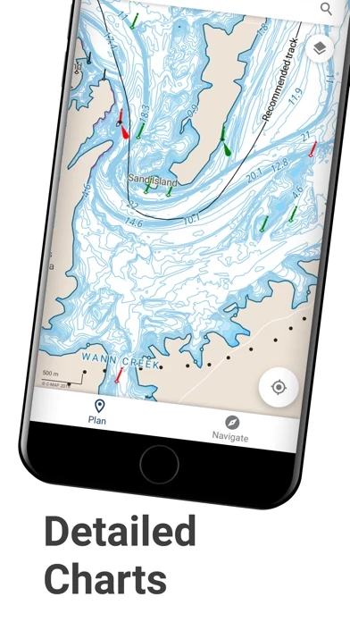
- Offline maps for viewing data without mobile coverage or WiFi
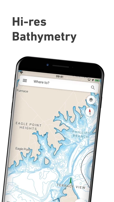
- Latest C-MAP maps with high-resolution bathymetry charts, custom shading, and thousands of Points of Interest
- Autorouting to set the best routes to favorite fishing waypoints automatically
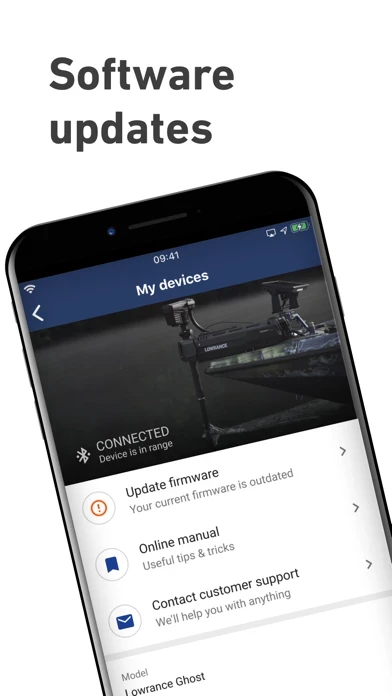
- Sync data with Lowrance devices when on-board
- Set Anchor Alerts and notifications for moving outside set locations
- Review data anytime, on- or off-the-water
- Free features include up-to-date C-MAP fishing maps, personal waypoints, routes and tracks, marine weather forecast, and more
- Premium features include offline maps, real-time AIS, navigation, traffic, high-resolution bathymetry, custom depth shading, shaded relief, anchor alerts, and satellite overlay
- Compatible with Elite ti2, Elite FS, HDS Carbon, and HDS Live devices with NOS software versions of 20.0 and above
- Continuous updates to ensure the most up-to-date fishing maps and functionalities
- Subscription-based with automatic renewal unless turned off at least 24-hours before the end of the current period
- Privacy policy and terms of service available for review.
Official Screenshots

Product Details and Description of
THE PERFECT FISHING COMPANION With all the latest and most detailed maps from C-MAP®, the this app App gives you the most accurate charting and layers on a mobile device. Now you can manage your favorite waypoints, discover new fishing spots, and plan your next trip with great ease. Simply step on-board, sync your data with your this app devices, and spend more time doing what you love: catching fish and saving your favorite spots for future trips. MANAGE YOUR WAYPOINTS - Create, store, edit and share your waypoints and fishing spots anytime, anywhere - Explore new waters and plan great fishing trips in advance - Offline maps - download your charts and view data, even without mobile coverage or WiFi DISCOVER NEW FISHING SPOTS AND LAKES - Latest C-MAP maps - high-resolution bathymetry charts, custom shading and thousands of Points of Interest, including ramps and fuel near you. - Autorouting - set the best routes to your favorite fishing waypoints automatically SYNC EASILY WITH YOUR DEVICE - Save your waypoints, fishing spots, and data with your this app devices when you step on-board. Giving you more time to concentrate on catching fish! - Set Anchor Alerts and notifications for moving outside set locations REVIEW YOUR DATA - Sync your app and this app device anytime, on- or off-the-water, so you can always take your latest fishing trip data with you. FREE FEATURES: - FREE up-to-date C-MAP fishing maps - Personal waypoints, routes and tracks - Manual and Autorouting direct to your favorite fishing spots - Measure distance tool - Thousands of Points of Interest - Marine weather forecast, including weather-related notifications - Weather along the route for 24 hours, up to 5 days for premium users - Weather Overlay for 24 hours, up to 5 days for premium users - Sharing Tracks - Referral - GPX import and export - Map personalization: boat size, favorite map type or view mode, and more... - Device registration - Device support: manuals, guides, videos - Mirroring and Control PREMIUM FEATURES: - Offline maps (Global chart) - Real-time AIS - Navigation: GPS data, navigation line, track record - Traffic - High-resolution Bathymetry - Custom Depth Shading - Shaded Relief - Anchor Alerts - Satellite Overlay Functionality involving direct integration with devices this app requires NOS software versions of 20.0 and above. Please check for compatibility with your device model: Elite ti2 Elite FS HDS Carbon HDS Live The this app App updates on a continuous basis to make sure you get a great experience and enjoy the most up-to-date fishing maps and functionalities. Be sure to check for updates regularly. Payment will be charged to iTunes Account at confirmation of purchase. Subscription automatically renews unless auto-renew is turned off at least 24-hours before the end of the current period. Account will be charged for renewal within 24-hours prior to the end of the current period, and identify the cost of the renewal. Subscriptions may be managed by the user and auto-renewal may be turned off by going to the user's Account Settings after purchase. Links to Your Privacy Policy and Terms of Use. Any unused portion of a free trial period, if offered, will be forfeited when the user purchases a subscription to that publication, where applicable Privacy policy https://appchart.this app.com/privacy.html Terms of service https://appchart.this app.com/tos.html
Top Reviews
By TomnJen+5
Live chat responds in 3hrs?
What a joke. I purchased a brand new elite 9 because I had great luck with a Hook series chart plotter because of all the features. This app does not work, so I tried to use the chat multiple times and the response time is listed as “usually less than 3hrs.” How is that any help?