GPS Camera 55. Field Survey Software
Company Name: Kalimex-Consulting s.r.o. @Blocoware & Stanislav Dvoychenko
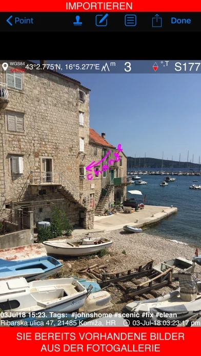
GPS Camera 55 Field Survey Overview
What is GPS Camera 55 Field Survey? The app allows users to capture and stamp photos with location, date, address, and notes. It also allows users to add hand-drawn annotations, search and filter images, organize them into collections/folders, import existing photos, and navigate to a point/image. The app also offers a pro pack upgrade that adds additional features such as the ability to create additional point/image collections, export/import capabilities, and extra protection of work and privacy with PIN code or biometric-based access options.
Features
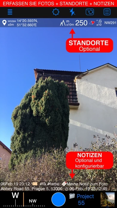
- Capture and stamp photos with location, date, address, and notes
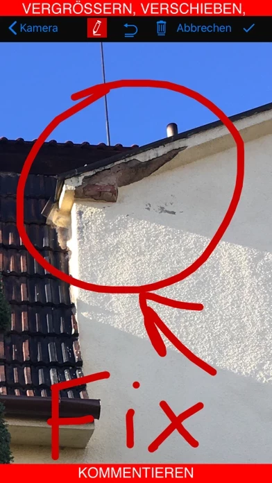
- Add hand-drawn annotations
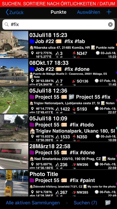
- Search and filter images by title, notes, tags, or sort by proximity and date
- Organize images into collections/folders
- Import existing photos from the photo library to restore their location, direction, and notes
- Supports decimal, dm, or dms coordinates formats as well as UTM and MGRS
- True or magnetic heading in degrees or mils
- Accuracy and altitude in either feet or meters
- Save photo automatically or open it in preview to annotate before saving
- Option to save a copy of the photo to the photo library, either or both original and stamped photo
- Zoom in/out in the photo preview and draw on the image with your finger or Apple pencil
- Notes overlay for the photo supports Title, Note, Tags/Folder, and Address
- Change notes and add more annotations later on
- Add an audio note for the image/point
- Timestamp options include many formats and languages
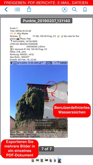
- Pro pack upgrade removes the basic version watermark and allows users to set up a watermark with their own image, text, and colors
- Share multiple points/images or the whole points collection
- Images can be shared with or without their location/notes text and with or without the location/notes overlay
- Transfer points/images in their entirety to another device using the KMZ (Google Earth archive) export format
- Navigate to a point/image
- Review image/point location on a map
- Pro pack upgrade adds additional features such as the ability to create additional point/image collections, export/import capabilities, and extra protection of work and privacy with PIN code or biometric-based access options.
Official Screenshots
Product Details and Description of
Capture and stamp photos with location, date, address, notes. Add hand drawn annotations. Search & filter your images by title, notes, tags or sort by proximity and date. Organize into collections/folders. Import existing photos from the photo library to restore their location, direction and even notes. LOCATION OVERLAY Supports decimal, dm or dms coordinates formats as well as UTM and MGRS. True or magnetic heading. Degrees or mils. Accuracy and altitude in either feet or meters. CAMERA AND CAPTURE SETTINGS Save photo automatically or open it in preview to annotate before saving. Option to save copy of the photo to the photo library, either or both original and stamped photo. ANNOTATE AND COMMENT Before or after saving the photo you can zoom in/out in the photo preview and draw on the image with your finger or Apple pencil. Notes overlay for the photo supports Title, Note, Tags/Folder and Address. Address can be pre-filled automatically based on the photo location or you can manually fill this field. You can change notes and add more annotations later on (MENU > POINTS > tap on an image in the point row). MENU > POINTS > tapping on a point row will open point editor where you can add an audio note for the image/point. Timestamp options include many formats and you should always find your preferred languages between them as well. WATERMARK Pro pack upgrade removes the basic version watermark and allows you to setup a watermark with your own image, text and colors, if needed. SHARE AND EXCHANGE You can select multiple points to share via MENU > POINTS or share the whole points collection via MENU > POINT COLLECTIONS. Images can be shared with or without their location/notes text and with or without the location/notes overlay. To transfer points/images in their entirety to another device, use the KMZ (Google Earth archive) export format - this allows to transfer points including images, image notes, annotations, audio notes, to another device. ORGANIZE, SEARCH & SORT You can organize images into collections/folders. Existing images/points can be moved between collections. MENU > POINTS screen enables you to search by point/image notes, address, tags fields, filter by creation month, sort by proximity or show points/images only for the specific collection. IMPORT MENU > IMPORT FROM LIBRARY will allow you to pick and import photo from the photo library and the app will do its best to parse tiff/exif/gps/iptc data in the photo to restore location, direction, notes for the stamp. NAVIGATE You can navigate to a point/image by opening it via MENU > POINTS and using Navigate button in the point editor screen. MAP VIEW Image/point location on a map can be reviewed by tapping on a MAP button in the point editor screen (MENU > POINTS > tap on a point row). == PRO PACK UPGRADE == You can do a lot with the basic functions in the app. PRO PACK upgrade adds: - Ability to create additional point/image collections. - Enables sharing of more than 5 points/images at once. - Export/import capabilities. In particular, KMZ export/import enables to transfer collections or selected waypoints between devices. - Ability to save hand drawn annotations for the image. - Extra protection of your work and privacy with PIN code or biometric based access options. - Removes the basic version watermark and allows to apply a custom watermark with your image, text, colors. Terms of Use: https://www.apple.com/legal/internet-services/itunes/dev/stdeula/
Top Reviews
By princesigns
Great App
Only thing that needs to be added Is a map overview of where the pictures were taken. I use this app for work and if it had that I would be able to see areas I’ve been in and areas I haven’t been in
By ichigo farmer
Wonderful app
I purchased this app so I can take pictures and submit the pictures to different governmental agencies and auditing agencies as well. They need the GPS coordinates on the pictures. For documentation. This is a great app for this. I have three other picture apps but this is the best!
By Merc123ooo
Best freebie I’ve found
Awesome app! I do delivery and need photo proof with non-contact deliveries. The GPS address plus coordinates gives me double locating points versus one or the other. The address isn’t always perfect (rarely off) so the coordinates help.