FarWide Overview
What is FarWide?
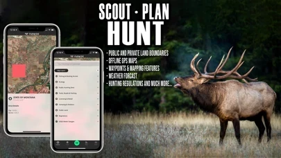
FarWide is a free mobile application that provides outdoor enthusiasts with the most relevant and updated information on fishing, hunting, camping, and outdoor recreation. It is a digital platform that connects and engages people with outdoor experiences, providing them with Outdoor Intelligence™. The app offers a fully-enabled GPS that turns smartphones into the most accurate offline location provider, allowing users to view land ownership maps, hunting units, fishing locations, government recreational map layers, and much more.
Features
- Free download
- Aerial view spot locator with GPS-based satellite imagery
- Web maps for scouting at home and syncing with mobile devices
- Satellite and topographic maps with GPS navigation
- Nationwide hunting and fishing access across public and private lands
- Hunting seasons, regulations, licenses, and harvest data and boundaries by all species across individual states
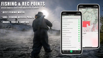
- Fishing locations, regulations, licenses, and water gauges with rankings by water fishing quality and species breakdown
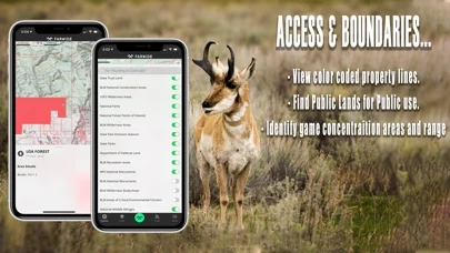
- Private land boundary, owner name, and address for all 50 states
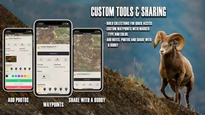
- Customizable waypoints to navigate back to fishing access points, basecamps, or hunt stands
- Add notes and photos for favorite hunting and fishing spots and experiences
- Create and save offline maps to use in remote locations
- Share maps with others for free
- Create search collections of saved hunt maps, access, and information
- Turn-by-turn navigation and directions to access points
- Trailheads and trails, campsite locations, license agents, hunting check stations, shooting ranges, boat ramps, fish attractors, wildlife habitat, historical fires and timber harvests, GPS public hunting sites, fishing and boating access, hunting management zones, game migration zones, and wintering.
Official Screenshots

Product Details and Description of
this app brings the most relevant, and upgraded fishing, hunting, camping and outdoor recreation information and news to the palms of adventurous hunters, shooters, and fishermen, FREE of cost. Built as a digital platform to connect and engage people with outdoor experiences, this app is Outdoor Intelligence™. As a fully-enabled FREE GPS on mobile devices, users can turn their smartphones into the most accurate Offline location provider to view land ownership maps, hunting units with associated regulations and data, water bodies designated by fishing quality and rank, government recreational map layers, and much more. KNOW & GO outdoors with this app! ▶ FREE APPLICATION FEATURES ● Free Download ● Aerial view spot locator, with GPS based satellite imagery ● Web maps for scouting at home (www.this app.com) and syncing with your mobile device. ● Satellite and topographic maps with GPS navigation ● Nationwide hunting and fishing access across public & private lands. ● Hunting seasons, regulations, and license, and harvest data and boundaries by all species across individual states. ● Fishing locations, regulations, and license and water gauges with rankings by water fishing quality and species breakdown. ● Private land boundary, owner name & address for all 50 states. ● Free of cost, customizable waypoints (by icon and color) to navigate back to your fishing access point, basecamp, or hunt stand. ● Add notes and photos for your favorite hunting and fishing spots and experiences. ● Create and save offline maps to use in remote locations. NOTE: Cellular network coverage is NOT needed, as our GPS technology allows you to save base maps and layers for offline maps. Share your maps with others absolutely free of cost. ● Create search collections of saved hunt maps, access, and information. ● Turn-by-turn navigation & directions to access points. ● Trailheads and trails, campsite locations, license agents, hunting check stations, shooting ranges, boat ramps, fish attractors, wildlife habitat, historical fires & timber harvests, GPS public hunting sites, fishing and boating access, hunting management zones, game migration zones and wintering. ▶ FEEDBACK: Want to request new features or content? Please contact us! HELLO@this app.COM
Top Reviews
By Big Dawg Sherm
Must Have for Outdoor Lovers!
I have been waiting for an app like this for a very long time. The maps are super useful for planning my trips!
By Irish Mols
Best outdoor mapping app!
This app is huge for my family! We used it all summer from New Hampshire to Montana to the ocean! Highly recommend!!
By maxsteel828
Out of date for hunting seasons
I live in South Carolina and some of our hunting seasons have started already like deer in zones 3-4.Morning dove, Canada geese started 9/2/19